

Adina Sommer
Antique and Contemporary Art
Winzerer Str. 154
80797 München
telephone
+49 89 304714
business hours:
by appointment
Email
![]()


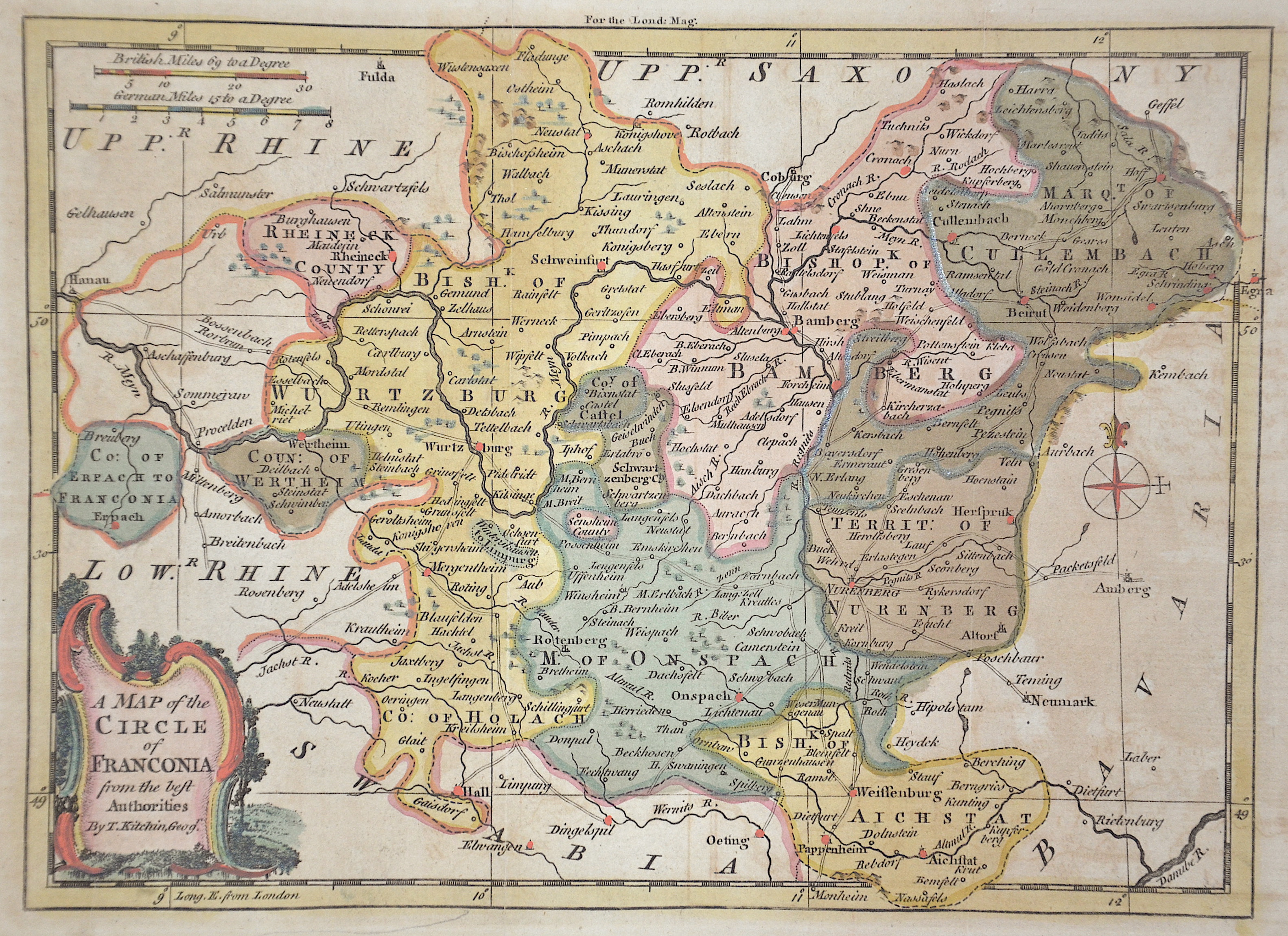
A map of the cercle of Franconia

| Article ID | EUD1379 |
Title | A map of the cercle of Franconia |
Description | Map shows total Franconia with Wuerzburg, Bamberg, Kulmbach, Ansbach, Nuremberg and Aichstaett. |
| Year | ca. 1740 |
Artist | Kitchin (Kitchen) (1718-1784) |
Thomas Kitchin (or Thomas Kitchen (1718–1784) was an English engraver and cartographer, who became hydrographer to the king. He was also an author, who wrote about the history of the West Indies. He produced John Elphinstone's map of Scotland (1746), Geographia Scotiae (1749), and The Small English Atlas (1749) with Thomas Jefferys. The Large English Atlas (with Bowen 1749–60) was a serious attempt to cover England at large scale. In 1755 Kitchin engraved the Mitchell Map map of North AmericaHe worked for London Magazine. He produced 170 maps for London Magazine (1747–83). Kitchin was the head hydrographer for the King of England. Kitchin frequently stole the works of other cartographers, which is one reason why he created so much work as a cartographer. His book, The Present State of the West-Indies: Containing an Accurate Description of What Parts Are Possessed by the Several Powers in Europe was published in 1778 by R. Baldwin in London. | |
Historical Description | The Franconia fell to today's Franconia region with their victories over the Alemanni and Thuringians in their core areas in the 6th century. After the Franconian divisions, the Francia orientialis from the areas of the dioceses of Mainz, Worms, Würzburg and Speyer was added, and later the diocese of Bamberg was added. In the 7th century, the Slavs began to populate the northeastern parts of the region from the east, since the areas of today's Upper Franconia were sparsely populated (Bavaria Slavica). Charlemagne developed the areas around the Main into a royal province. From the middle of the 9th century, the Duchy of the Tribes, one of the five Duchies of the Eastern Franconian Empire, was established. From the 12th century, the Nuremberg Castle was the seat of the castle county of Nuremberg. From around 1190, the burgrave was ruled by the Zollern, the Frankish line of the later Hohenzollern, who represented the German emperor in the 19th and 20th centuries. Franconia already played an important role for the kingship in the time of Rudolf von Habsburg, the Itineraries of the following kings attested to the favoritism of the Rhine-Main region. In 1376 the Swabian Association of Cities was founded, which later also included several Franconian imperial cities. In July 1500, during the reign of Emperor Maximilian I, the empire was divided into imperial circles in the course of the imperial reform movement, which led to the creation of the Franconian imperial circle in 1512. From today's perspective, the Franconian Imperial Circle is sometimes considered to be an important basis for the development of a Franconian sense of community that still exists today. Franconia played an important role in the expansion of Martin Luther's Reformation. From 1552, the margrave Albrecht Alcibiades tried to break the supremacy of the mighty imperial city of Nuremberg and to secularize the possessions of the princes in order to create a duchy that he ruled. Large areas of Franconia were finally devastated in the fighting until King Ferdinand I, with several dukes and princes, decided to subjugate Albrecht. In 1608, Protestant sovereigns united in the Reich to form the so-called Union. The Catholic side reacted in 1609 with a counter-alliance, the league. The contrasts between the two camps eventually led to the Thirty Years' War, which became the greatest burden of cohesion within the Franconian Empire. From 1803 the later Kingdom of Bavaria received large parts of Franconia with the main deputation of the Imperial Deputation under the pressure of Napoleon Bonaparte through secularization and mediatization. Through the Rhine Confederation, Bavaria, Württemberg, Baden and other areas became more closely linked to France, which disintegrated the Holy Roman Empire and the Franconian Empire in 1806. |
| Place of Publication | London |
| Dimensions (cm) | 17,5 x 24 cm |
| Condition | Very good |
| Coloring | original colored |
| Technique | Copper print |