

Adina Sommer
Antique and Contemporary Art
Winzerer Str. 154
80797 München
telephone
+49 89 304714
business hours:
by appointment
Email
![]()


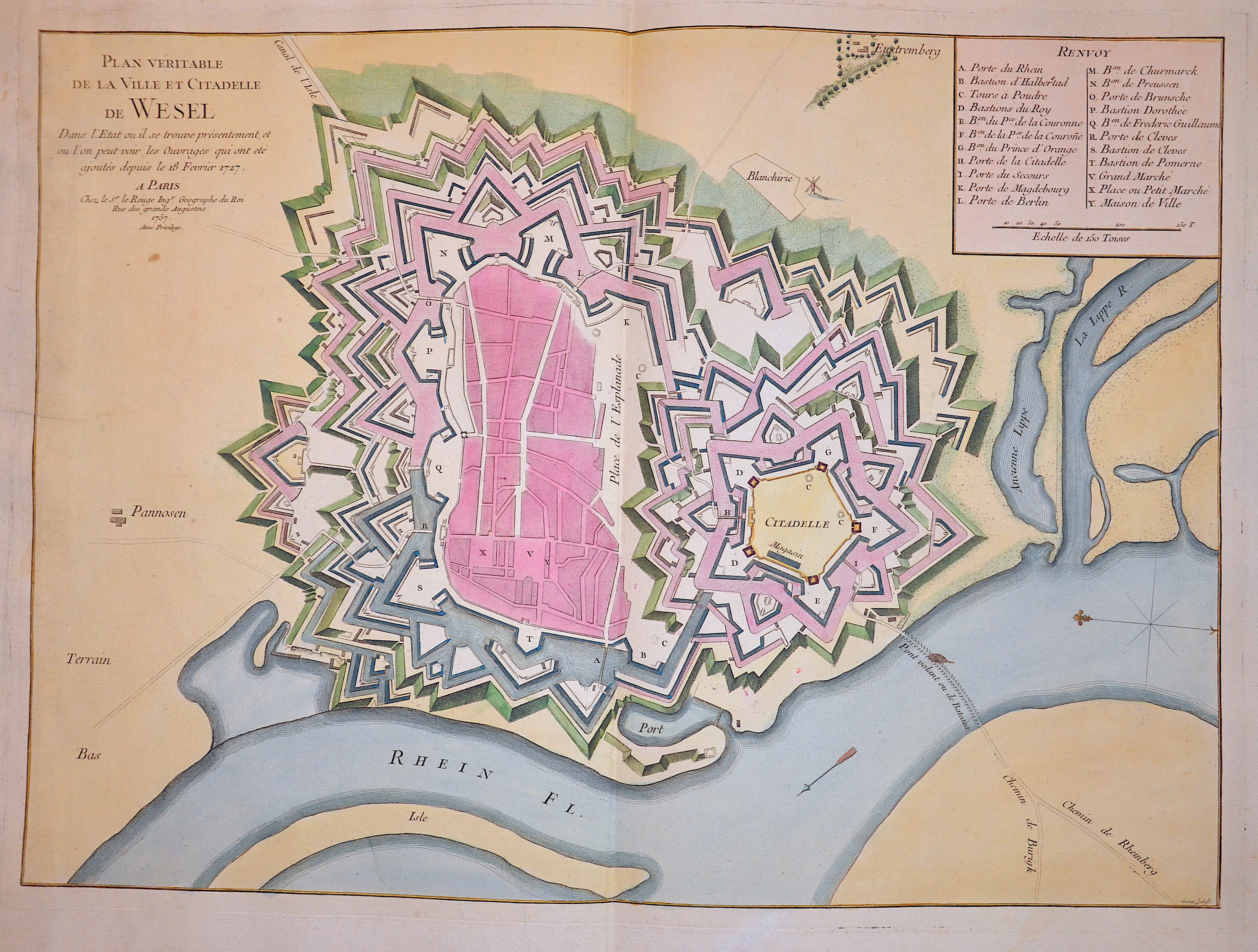
Plan veritable de la Ville et Citadelle de Wesel. Dans l’Etat ou il se trouve présentement, et ou l’on peut voir, les Ouvrages..

| Article ID | EUD3173 |
Title | Plan veritable de la Ville et Citadelle de Wesel. Dans l’Etat ou il se trouve présentement, et ou l’on peut voir, les Ouvrages.. |
Description | Decorative city map of Wesel an der Lippe in North Rhine-Westphalia and a city index. The city originated from a Franconian manor that was first recorded in the 8th century. In the 12th century, the Duke of Clèves took possession of Wesel. The city became a member of the Hanseatic League during the 15th century. Within the Duchy of Cleves, Wesel was second only to Cologne in the lower Rhine region as an entrepôt. It was an important commercial centre: a clearing station for the transshipment and trading of goods. |
| Year | dated 1757 |
Artist | Le Rouge (1707-1790) |
Georges Louis Le Rouge (ca 1707 -1790) He was established as a publisher, compiler and editor of maps in Paris. He later became the Ingenieur Geographe de Roi. Le Rouge is particularly known for such atlas works as the Atlas Nouveau of 1746 and the Atlas Nouveau Portatif or the Introduction A La Geographie of 1756. French publications of some merit. | |
Historical Description | The town of Wesel lies at the mouth of the Lippe and the Wesel-Datteln Canal into the Rhine. The first verifiable settlement on today's Wesel urban area was established after the Migration Period in the area where the Lippe then flowed into the Rhine, the base of Lippeham, from where Emperor Charlemagne undertook several campaigns against the Saxons and Danes. The further development of this settlement is largely unknown, but it was probably flooded by the Rhine and Lippe and subsequently abandoned. The origin of today's town is thought to be a Frankish estate, which was located in the area of today's Kornmarkt. |
| Place of Publication | Paris |
| Dimensions (cm) | 48 x 66 cm |
| Condition | Perfect condition |
| Coloring | colored |
| Technique | Copper print |