

Adina Sommer
Antique and Contemporary Art
Winzerer Str. 154
80797 München
telephone
+49 89 304714
business hours:
by appointment
Email
![]()


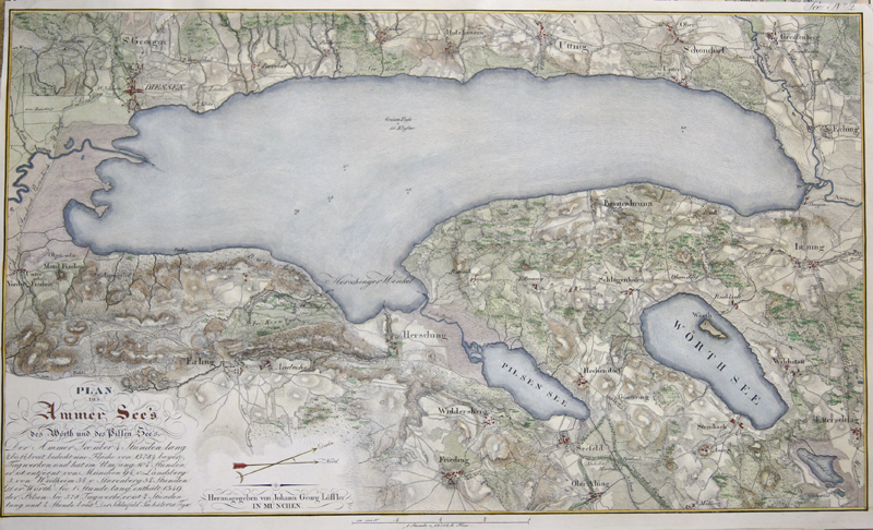
Plan des Ammer See’s des Wörth und des Pilsen See’s.

| Article ID | EUD3463 |
Title | Plan des Ammer See’s des Wörth und des Pilsen See’s. |
Description | Special hydrographical map of the Ammer lake in upper Bavaria with the deepths of the Woerth lake, Pilsen lake, also showing the cities of Diessen am Ammersee, Utting, Schondorf, Greifenberg, Eching, Stegen, Inning am Ammersee, Breitenbrunn, Hersching, Erling, Andechs, Widdersberg, Seefeld, Oberalting, Hechendorf, Steinebach, Walchstadt am Wörthsee, Etterschlag,… ,…from Topographische Bureau 1812-1867 (vgl. Topographischer Atlas von Baiern). |
| Year | ca. 1807 |
Artist | Riedl (1746-1809) |
Adrian Franz Xaver Florian Riedl, from 1790 von Riedl (1746-1809) was a German topographer and cartographer, coming from a family of cartographers who determined construction and surveying in Bavaria for over 75 years. In 1764 he fell on the scholars of the Bavarian Academy of Sciences in Munich through his cartographic implementation of the survey results of the French cartographer César François Cassini de Thury (1714–1784), which he had carried out in 1761 and 1762 in Bavaria. After the examination by the academy, Riedl was appointed electoral land geometer in 1766 and commissioned with the recording of the Bavarian road network in 1769. Over the years he followed his father in his positions as court chamber councilor (1771) and water, bridge and road construction commissioner ( 1772) according to. Together with General Building Director Joseph Aloys von Hofstetten, he developed the institutionalization and professionalization of construction and surveying. Adrian von Riedl's cartographic work of the Bavarian colonel and in various offices with road, bridge and especially hydraulic engineering could have been crowned with the Stromatlas if it had not been unfinished due to his sudden death. Nevertheless, the sheets published in several subscription deliveries were and still are the best and most accurate reproduction of Bavarian waters and could only be replaced by the Topographical Bureau 1812-1867 (see Topographical Atlas of Baiern) in the course of the official state survey. | |
Historical Description | The existence of a Bavarian tribal duchy has been documented since 555, which became part of the Frankish domain under the Merovingians. From 1180 to 1918 Bavaria was ruled by the Wittelsbachers as a territorial duchy. Bavaria experienced a period of numerous divisions into individual duchies from 1255 to 1503. Shortly before the first reunification, Ludwig IV. In 1328 became the first Wittelsbacher to become emperor, which meant a new high point in power for Bavaria. At the same time, however, the prince-archbishopric of Salzburg finally separated from the mother country Bavaria. In 1429, after the Straubing-Holland line became extinct, the Duchy of Bavaria-Straubing was divided between the Munich, Ingolstadt and Landshut lines. In 1447, Bavaria-Ingolstadt fell to Bavaria-Landshut, which in turn was won by Bavaria-Munich in the War of Succession in Landshut in 1503. The division of the country came to an end through the Primogenitur Act of Duke Albrecht IV of 1506. Bavaria took a leading position in the Counter-Reformation and emerged from the Thirty Years' War with territorial gains and the rise to the Electorate. In 1620, the troops of the Catholic League, under the leadership of the Bavarian general Tilly, defeated the Protestants in the Battle of the White Mountains near Prague. Then Tilly had the Palatinate occupied. As a thank you, Maximilian I received the electoral title in 1623 and the Upper Palatinate he occupied as war compensation in 1628. After the war, Elector Ferdinand Maria devoted himself to the reconstruction of the devastated country and pursued a cautious neutrality policy. During the War of the Spanish and Austrian Succession and in the course of Maximilian II. Emanuel's great power policy and later his son Karl Albrecht, Austria was twice temporarily occupied by absolutist Bavaria. In 1705 the Bavarian people rose against the imperial occupation. Only the battle of Aidenbach on January 8, 1706 ended with the complete defeat of the popular uprising. After Karl Albrecht's coronation, large parts of the electorate were occupied again until 1744. Karl Albrecht's son Maximilian III. Joseph finally ended the great power policy of his predecessors in 1745 and devoted himself to internal reforms. After the extinction of the old Bavarian line of the Wittelsbacher, the double electorate of Kurpfalz-Bavaria was created in 1777 under the reign of the Elector Karl Theodor from the Palatinate line of the Wittelsbacher. At the time of Napoleon, Bavaria was initially on the side of France and was able to record large territorial gains through secularization and mediatization. Salzburg, Tyrol, Vorarlberg and the Innviertel region, which was lost in 1779, fell temporarily to Bavaria. In the Peace of Pressburg, which was concluded on December 26, 1805 between France and the German Emperor Franz II, Bavaria, allied with Napoleon, was proclaimed a kingdom. King Max I. Joseph's Minister Maximilian Graf von Montgelas is considered the creator of the modern Bavarian state. In 1806 Napoleon Bonaparte elevated Bavaria to a kingdom. At the Vienna Congress in 1814, Bavaria was able to retain a large part of the area's profits as a victorious power, including what was now northern Bavaria, parts of Swabia and the Palatinate. In 1918 the Wittelsbach monarchy collapsed in the November Revolution. King Ludwig I, who had ruled since 1825, developed the Bavarian capital Munich into an art and university city. After the occupation by American troops, Bavaria became part of the newly founded Federal Republic in 1949. |
| Place of Publication | Munich |
| Dimensions (cm) | 38,5 x 64,5 cm |
| Condition | Wormhole perfectly restored |
| Coloring | colored |
| Technique | Copper print |