

Adina Sommer
Antique and Contemporary Art
Winzerer Str. 154
80797 München
telephone
+49 89 304714
business hours:
by appointment
Email
![]()


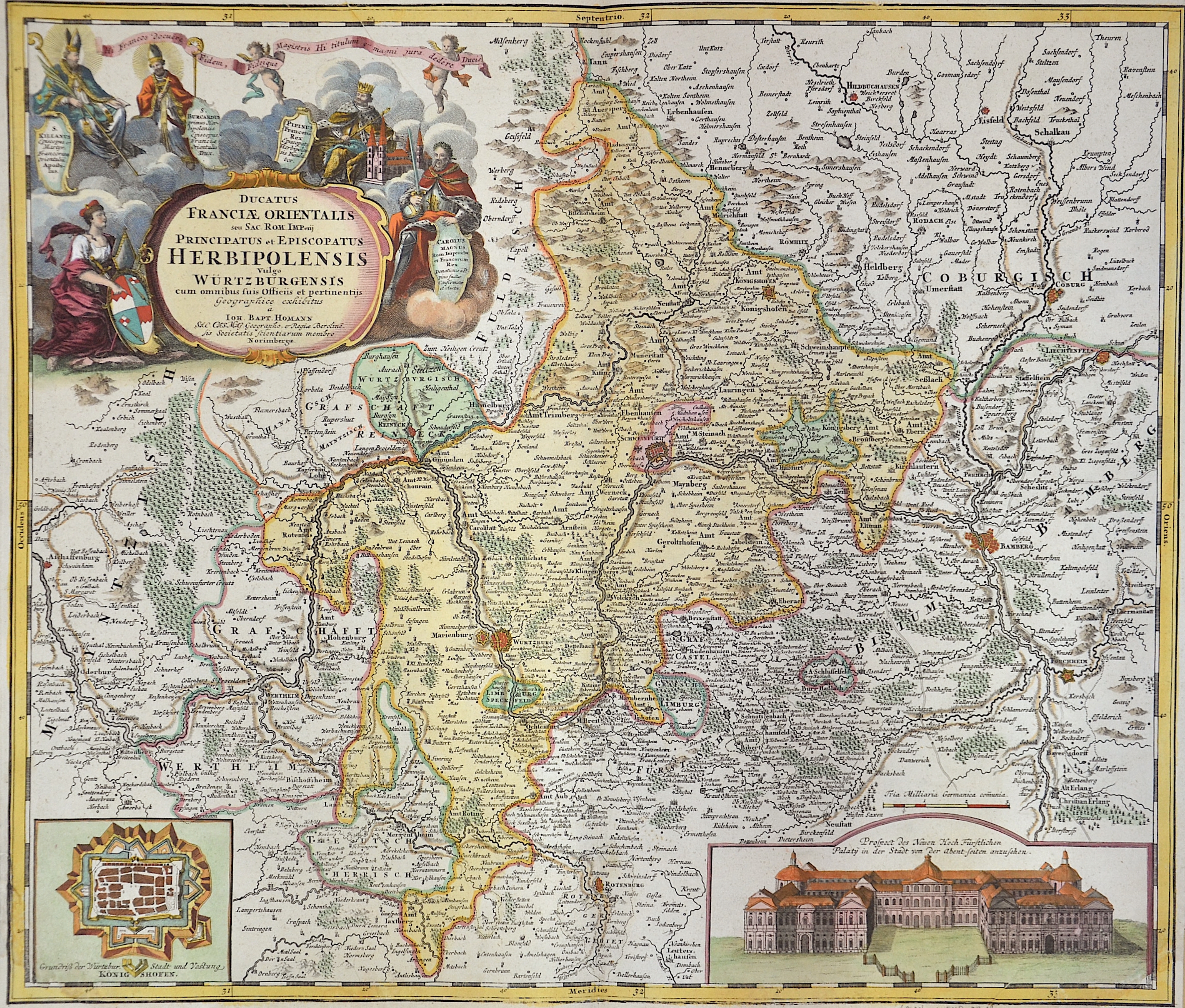
Ducatus Franciae orientalis seu sac Rom Imperij……Herbipolensis vulgo Würtzburgensis….

| Article ID | EUD2318 |
Title | Ducatus Franciae orientalis seu sac Rom Imperij……Herbipolensis vulgo Würtzburgensis…. |
Description | Map shows Franconia and the area of Würzburg with Schweinfurt, Rotenburg and Bamberg. A city map of Wurzburg, the fortress and city view.The titel cartouche shows the emperors of Franconia of this time. |
| Year | ca. 1710 |
Artist | Homann (1664-1724) |
Johann Babtiste Homann (1664-1724), Nuremberg, was born in Oberkammlach, the Electorate of Bavaria. Although educated at a Jesuit school, and preparing for an ecclesiastical career, he eventually converted to Protestantism and from 1687 worked as a civil law notary in Nuremberg. He soon turned to engraving and cartography; in 1702 he founded his own publishing house. Homann acquired renown as a leading German cartographer, and in 1715 was appointed Imperial Geographer by Emperor Charles VI. Giving such privileges to individuals was an added right that the Holy Roman Emperor enjoyed. In the same year he was also named a member of the Prussian Academy of Sciences in Berlin. Of particular significance to cartography were the imperial printing privileges (Latin: privilegia impressoria). These protected for a time the authors in all scientific fields such as printers, copper engravers, map makers and publishers. They were also very important as a recommendation for potential customers. In 1716 Homann published his masterpiece Grosser Atlas ueber die ganze Welt (Grand Atlas of all the World). Numerous maps were drawn up in cooperation with the engraver Christoph Weigel the Elder, who also published Siebmachers Wappenbuch. Homann died in Nuremberg. He was succeeded by the Homann heirs company, which was in business until 1848. The company was known as Homann Erben, Homanniani Heredes, or Heritiers de Homann abroad. | |
Historical Description | The earliest mentions of the place name are found around 704 A.D., by the geographer of Ravenna, with the name Uburzis and mentioned in a document in 704 as castello Virteburh. Already in the 10th century an etymology was made in the form Herbipolis on the basis of Latin herba '(healing) herbs'. Würzburg would thus mean 'castle on the herb-rich place'. Ludwig the Pious granted the Würzburg bishops a customs privilege around 820, and the right to hold markets and mint coins in 1030. The marketplace frequented by long-distance merchants and wholesalers in the 10th century was located in today's Domstrasse. In 1188, Hohenstaufen farms and proprietary estates in the city and diocese of Würzburg were mentioned in a treaty between Emperor Frederick I Barbarossa and King Alfonso VIII of Castile. The Prince-Bishop Julius Echter of Mespelbrunn was significant for the history of Würzburg. He founded the Juliusspital, reestablished the university and extended the fortress on the Marienberg as a Renaissance castle. He was known far beyond Würzburg as a counter-reformer and persecutor of witches. From 1631 to 1634, Würzburg was occupied by the Swedes, and after the Thirty Years' War and the Peace of Westphalia in 1648, the baroque, star-shaped expansion of Würzburg's fortifications took place, including the creation of new fortress and city gates. Under Prince-Bishop Johann Philipp II von Greiffenclau zu Vollraths and his successors, especially from the House of Schönborn, there were significant artistic and especially building activities from 1699. They still characterize the cityscape today. |
| Place of Publication | Nuremberg |
| Dimensions (cm) | 48 x 56,5 cm |
| Condition | Lower left and right corner perfectly replaced |
| Coloring | original colored |
| Technique | Copper print |