

Adina Sommer
Antique and Contemporary Art
Winzerer Str. 154
80797 München
telephone
+49 89 304714
business hours:
by appointment
Email
![]()


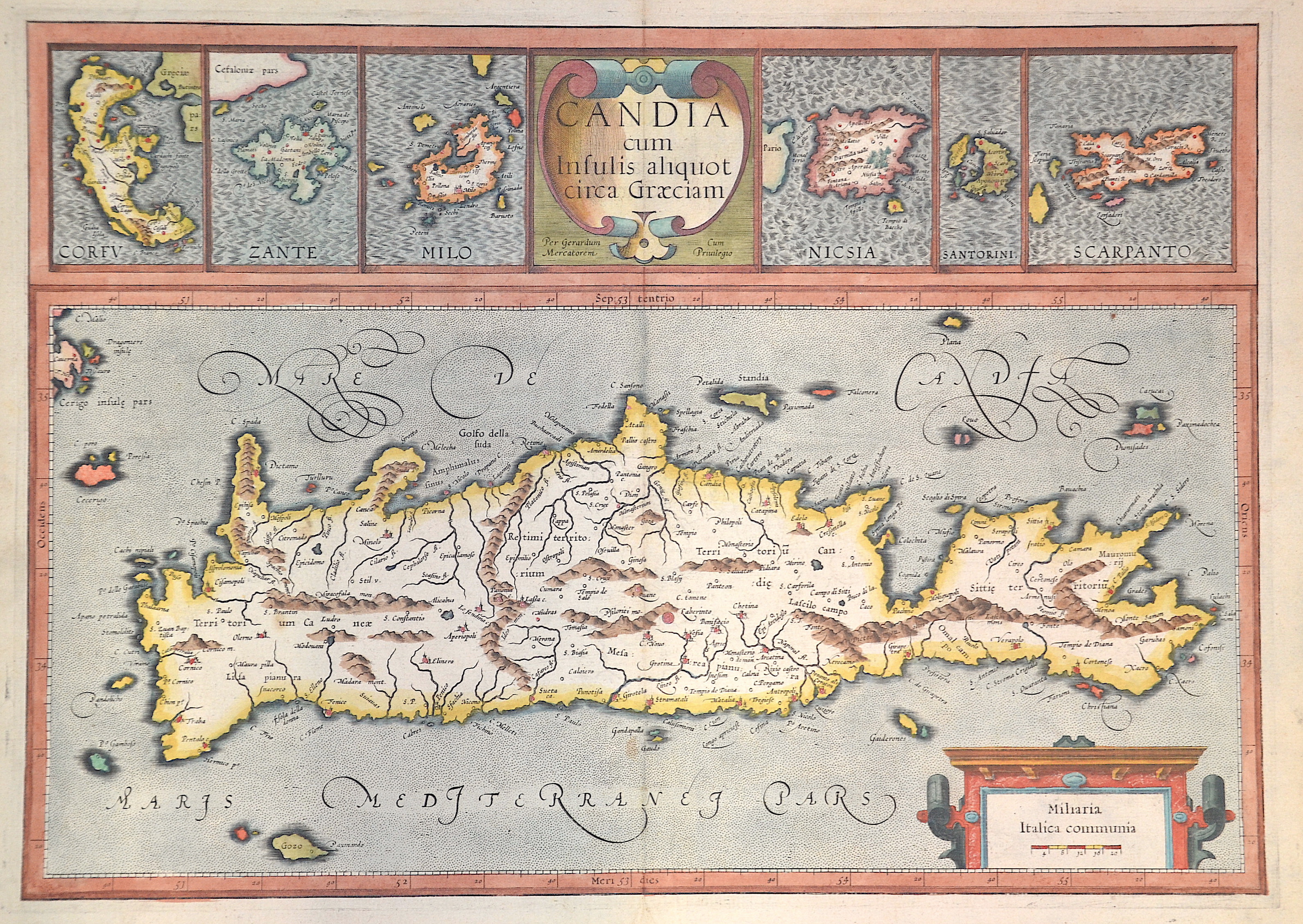
Candia cum Insulis aliquot circa Graeciam

| Article ID | EUK4915 |
Title | Candia cum Insulis aliquot circa Graeciam |
Description | Map shows the island of Crete and a cartouche with mileage indicator. Above a title cartouche and six partial maps with the islands: Corfu, Zakynthos (Zante), islands in the Ionian Sea, Milos (a Greek island in the Aegean Sea)," Nicsia", Santorini and "Scarpanto". |
| Year | ca. 1602 |
Artist | Mercator (1512-1594) |
Gerardus Mercator (1512 - 1594). He was a cartographer, philosopher and mathematician. He is best known for his work in cartography, in particular the world map of 1569 based on a new projection which represented sailing courses of constant bearing as straight lines. He is renowned to the present day as the cartographer who created a world map based on a new projection which represented sailing courses of constant bearing as straight lines. In his own day he was the world's most famous geographer but in addition he had interests in theology, philosophy, history, mathematics and magnetism as well as being an accomplished engraver, calligrapher and maker of globes and scientific instruments. He wrote few books but much of his knowledge is to be found in the copious legends on his wall maps and the prefaces that he composed for his atlas ,the first in which the term "atlas" appears and the sections within it. | |
Historical Description | The island of Crete is first referred to as Kaptara in texts from the Syrian city of Mari from the 18th century BC, which are later repeated in Neo-Assyrian records and in the Bible (Caphtor). It was also known in ancient Egypt as Keftiu, strongly suggesting that a similar form to both was the Minoan name for the island. In classical times, Crete lay on the edge of the Greek cultural area, it was regarded as the "island of 100 poleis" and was therefore divided into numerous small city-states. The stone-carved legal text of the then powerful polis of Gortyn is the only completely preserved codex of this type from Greek antiquity. From 1645 to 1648, the Turks conquered almost the entire island and incorporated it into the Ottoman Empire as Girit, with only Candia withstanding a siege until 1669. Numerous uprisings by the population in the 19th century against Ottoman sovereignty were bloodily suppressed. From 1830 to 1840, Crete was formally under the administration of the Vali of Egypt, Muhammad Ali Pasha. In 1898, the intervention of France, Russia and the United Kingdom forced Crete into almost complete autonomy under the sovereignty of the High Porte. The Treaty of London in 1913 finally made Crete part of the Greek state, and a comprehensive population exchange was agreed in the Treaty of Lausanne in 1923. |
| Place of Publication | Duisburg |
| Dimensions (cm) | 34 x 48 cm |
| Condition | Perfect condition |
| Coloring | original colored |
| Technique | Copper print |