

Adina Sommer
Antique and Contemporary Art
Winzerer Str. 154
80797 München
telephone
+49 89 304714
business hours:
by appointment
Email
![]()


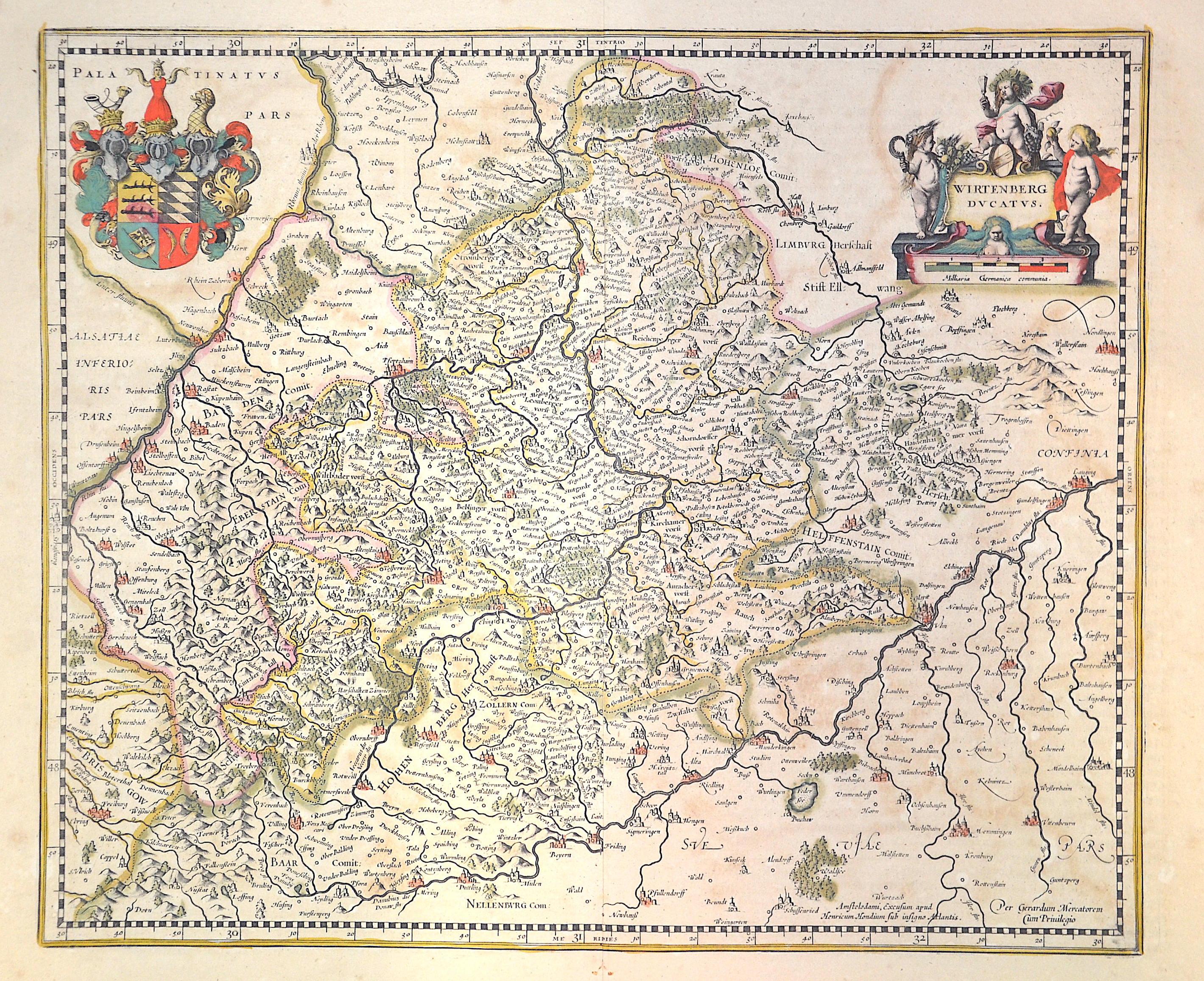
Wirtemberg ducatus

| Article ID | EUD0513 |
Title | Wirtemberg ducatus |
Description | Map shows the whole of Württemberg with a title cartouche and the coat of arms of the Duchy of Württemberg. After Mercator. |
| Year | ca. 1610 |
Artist | Hondius (1597-1650) |
Jodocus Hondius (1563 –1612) was a Dutch engraver, and cartographer. He is best known for his early maps of the New World and Europe, for re-establishing the reputation of the work of Gerard Mercator, and for his portraits of Francis Drake. He helped establish Amsterdam as the center of cartography in Europe in the 17th century. He was born in Wakken and grew up in Ghent. In his early years he established himself as an engraver, instrument maker and globe maker. In 1584 he moved to London to escape religious difficulties in Flanders. While in England, Hondius was instrumental in publicizing the work of Francis Drake, who had made a circumnavigation of the world in the late 1570s. In particular, in 1589 Hondius produced a now famous map of the bay of New Albion, where Drake briefly established a settlement on the west coast of North America. Hondius' map was based on journal and eyewitness accounts of the trip and has long fueled speculation about the precise location of Drake's landing, which has not yet been firmly established by historians. Hondius is also thought to be the artist of several well-known portraits of Drake that are now in the National Portrait Gallery in London. In 1593 he moved to Amsterdam, where he remained until the end of his life. In co-operation with the Amsterdam publisher Cornelis Claesz. in 1604 he purchased the plates of Gerard Mercator's Atlas from Mercator's grandson. Mercator's work had languished in comparison to the rival Theatrum Orbis Terrarum by Ortelius. Hondius republished Mercator's work with 36 additional maps, including several which he himself had produced. Despite the addition of his own contributions, Hondius gave Mercator full credit as the author of the work, listing himself as the publisher. Hondius' new edition of Mercator's work was a great success, selling out after a year. Hondius later published a second edition, as well as a pocket version Atlas Minor. The maps have since become known as the ""Mercator/Hondius series"" . In the French edition of the Atlas Minor we find one of the first instances of a thematic map using map symbols. This is a map entitled Designatio orbis christiani (1607) showing the dispersion of major religions. Between 1605 and 1610 he was employed by John Speed to engrave the plates for Speed's The Theatre of the Empire of Great Britaine. Hondius died, aged 48, in Amsterdam. After his death, his publishing work in Amsterdam was continued by his widow, two sons, Jodocus II and Henricus, and son-in-law Johannes Janssonius, whose name appears on the Atlas as co-publisher after 1633. Eventually, starting with the first 1606 edition in Latin, about 50 editions of the Atlas were released in the main European languages. In the Islamic world, the atlas was partially translated by the Turkish scholar Katip Çelebi. The series is sometimes called the ""Mercator/Hondius/Janssonius"" series because of Janssonius's later contributions. | |
Historical Description | Baden-Wuertemberg is a state in southwest Germany, east of the Rhine, which forms the border with France. It is is formed from the historical territories of Baden, Prussian Hohenzollern, and Württemberg, and also parts of Swabia. Baden Würtemberg was only founded in 1952 by the merger of the states of Württemberg-Baden, Baden and Württemberg-Hohenzollern. Today the most populous city of Baden-Württemberg is the state capital Stuttgart, followed by Karlsruhe and Mannheim. Other major cities are Freiburg im Breisgau, Heidelberg, Ulm, Heilbronn, Pforzheim and Reutlingen. The early modern period was marked by the Reformation and the expansion efforts of the emerging states of Austria, Prussia, France and Sweden. Conflicts such as the Peasant War, the Thirty Years' War and the Palatinate War of Succession resulted from these. One of the focal points of the fighting, with corresponding consequences for the population and the economy, was in what is today Baden-Württemberg, which remained extremely fragmented territorially. At the beginning of the 19th century, around 300 states still had territorial rights in what is now Baden-Württemberg, but their number was reduced to four after the dissolution of the Old Empire. The Kingdom of Württemberg and the Grand Duchy of Baden were among the winners of the coalition wars. The two principalities of Hohenzollern-Sigmaringen and Hohenzollern-Hechingen survived mediatization due to their special relationship with Napoléon. In 1849, the Baden Revolution was put down by Prussian intervention forces, the Baden army was dissolved and rebuilt under Prussian leadership. In 1850 the two Hohenzollern states became the Prussian province of Hohenzollernsche Lande. With the new formation of the tribal duchies, the southern areas of what is now the state of Baden-Württemberg belonged to the Duchy of Swabia until the end of the High Middle Ages, the northern areas were located with the Duchy of Franconia. |
| Place of Publication | Amsterdam |
| Dimensions (cm) | 38 x 45 cm |
| Condition | Minor stains |
| Coloring | original colored |
| Technique | Copper print |