

Adina Sommer
Antique and Contemporary Art
Winzerer Str. 154
80797 München
telephone
+49 89 304714
business hours:
by appointment
Email
![]()


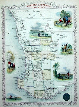
Wetsern Australia. Swan river

| Article ID | OZ0272 |
Title | Wetsern Australia. Swan river |
Description | Map shows the western part of Australia, a view of Perth and 5 representaions of landscape and natives |
| Year | ca. 1850 |
Artist | Tallis (1817-1876) |
John Tallis was an English cartographic publisher. His company, John Tallis and Company, published views, maps and atlases in London from roughly 1838 to 1851. | |
Historical Description | The first meeting between the native people and the British occurred on 29 April 1770 when Lieutenant James Cook landed at Botany Bay on the Kurnell Peninsula and encountered the Gweagal clan.He noted in his journal that they were confused and somewhat hostile towards the foreign visitors.Cook was on a mission of exploration and was not commissioned to start a settlement. He spent a short time collecting food and conducting scientific observations before continuing further north along the east coast of Australia and claiming the new land he had discovered for Britain. Prior to the arrival of the British there were 4,000 to 8,000 native people in Sydney from as many as 29 different clans. The earliest British settlers called the natives Eora people. ;Eora; is the term the indigenous population used to explain their origins upon first contact with the British. Its literal meaning is ;from this place;. Sydney Cove from Port Jackson to Petersham was inhabited by the Cadigal clan.The principal language groups were Darug, Guringai, and Dharawal. The earliest Europeans to visit the area noted that the indigenous people were conducting activities such as camping and fishing, using trees for bark and food, collecting shells, and cooking fish. |
| Place of Publication | London |
| Dimensions (cm) | 33,5 x 24 |
| Condition | Very good |
| Coloring | original colored |
| Technique | Steel engraving |