

Adina Sommer
Antique and Contemporary Art
Winzerer Str. 154
80797 München
telephone
+49 89 304714
business hours:
by appointment
Email
![]()


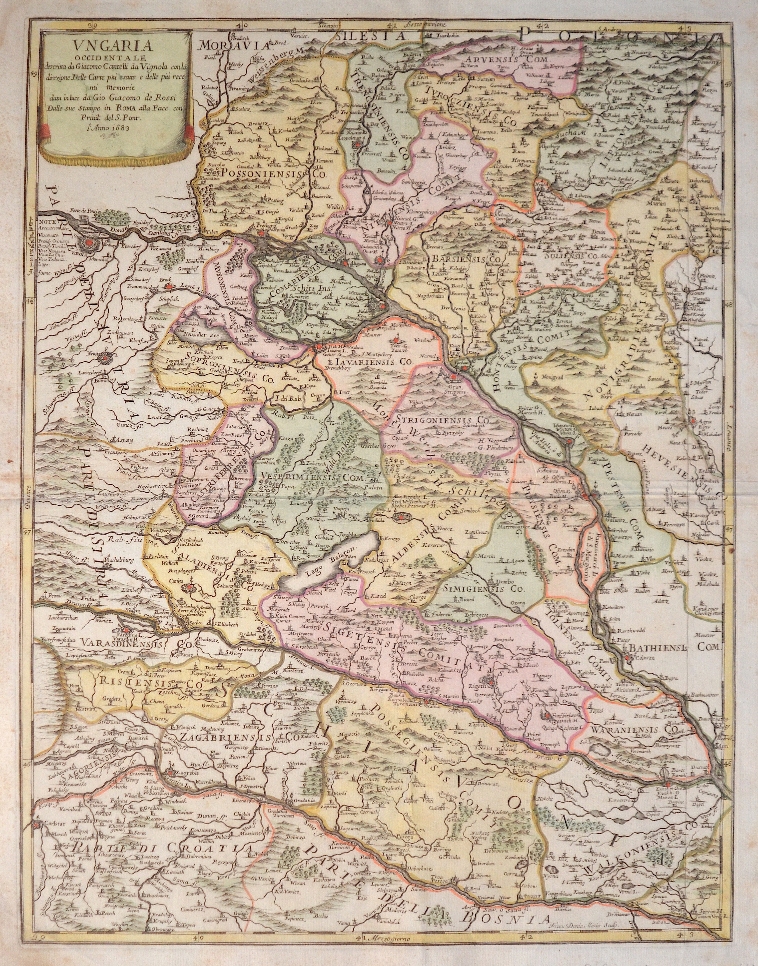
Ungaria Occidentale descrima da Giacomo Cantelli da Vignola con la direzione Delle Carte..

| Article ID | EUH4241 |
Title | Ungaria Occidentale descrima da Giacomo Cantelli da Vignola con la direzione Delle Carte.. |
Description | Map shows the western part of Hungaria. |
| Year | ca. 1683 |
Artist | Rossi (1627-1691) |
Giovanni Giacomo De' Rossi was the son of the founder of the most important and active printing press of the 17th century in Rome. Begun in 1633 by his father Giuseppe (1570-1639), the press passed firstly to Giacomo and to his brother Giandomenico (1619-1653), and then later to Lorenzo Filippo (1682-?); in 1738 it became the Calcografia Camerale, from 1870 until 1945 the Regia Calcografica, and today it is known as the Calcografia Nazionale. Here are conserved, amongst many others, the plates of Giambattista Piranesi (1720-1778). Giacomo De' Rossi was the most involved of all the various family members who ran the press, and he worked between 1638 and 1691, and was to take the company to the height of its success. De Rubeis was Giacomo Rossi's Latinized name, under which some of his maps appear in the early part of his career. | |
Historical Description | The Kingdom of Hungary existed in changing borders from 1001 to 1918 and 1920 to 1946, originating in what is now western Hungary and subsequently expanding its domain to include the entire territory of present-day Hungary, as well as the territory of Transylvania, the Kreish and Maramures (both in the Romanian part of the Partium), Slovakia, Vojvodina, the Romanian part of the Banat, Carpatho-Ukraine, Burgenland, Prekmurje, Croatia (except Dalmatia and Istria) and some smaller territories. The first king of the kingdom was Stephen I the Saint from the ruling dynasty of the Árpáds, who was formally recognized as king of Hungary in 1001, when Pope Silvester II granted him the title of "Apostolic Majesty". In 1396, the Ottomans had to face a crusader army under the Hungarian king and later emperor Sigismund, which was crushingly defeated at the Battle of Nicopolis. The European powers, first and foremost the Holy Roman Empire, which had not considered the Ottomans as a serious threat for too long, were faced with the ruins of their policies concerning the Ottoman Empire at the latest with the fall of the medieval Kingdom of Hungary (1526). In the following decades, therefore, the only thing that mattered was to prevent, as far as possible, the further advance of the Ottomans towards Central Europe. In 1526 the decision in the fight against the Ottoman Empire followed in the Battle of Mohács. The Hungarian King Louis II fell in the battle. The following Hungarian Civil War, in which John I was supported by the Turks, ended in 1538 with the Peace of Grosswardein. John Zápolya and Ferdinand were both allowed to continue to use the Hungarian royal title and to rule a part of Hungary. To forestall Habsburg claims, Suleyman I intervened and occupied Buda and central Hungary. Hungary was divided into three parts after 1540 according to the power relations created. The exact demarcation of the borders between the individual parts varied considerably. After the Habsburgs and their allies had pushed the Ottoman Empire back to the territories south of the Danube and the Sava and fixed this in the Peace of Karlowitz in 1699, the Kingdom of Hungary, which had never disappeared de jure, was also restored de facto. The k.u.k. Monarchy existed until its defeat in World War I, when Hungary denounced the Real Union as of October 31, 1918. A short time later, the Hungarian Republic was proclaimed. The kingdom was under several foreign dominations in its history and regained its sovereignty in 1867 as a federal (partial) state of Austria-Hungary. |
| Place of Publication | Rome |
| Dimensions (cm) | 56 x 43 cm |
| Condition | Tear at the right outer margin perfecrtly restored |
| Coloring | original colored |
| Technique | Copper print |