

Adina Sommer
Antique and Contemporary Art
Winzerer Str. 154
80797 München
telephone
+49 89 304714
business hours:
by appointment
Email
![]()


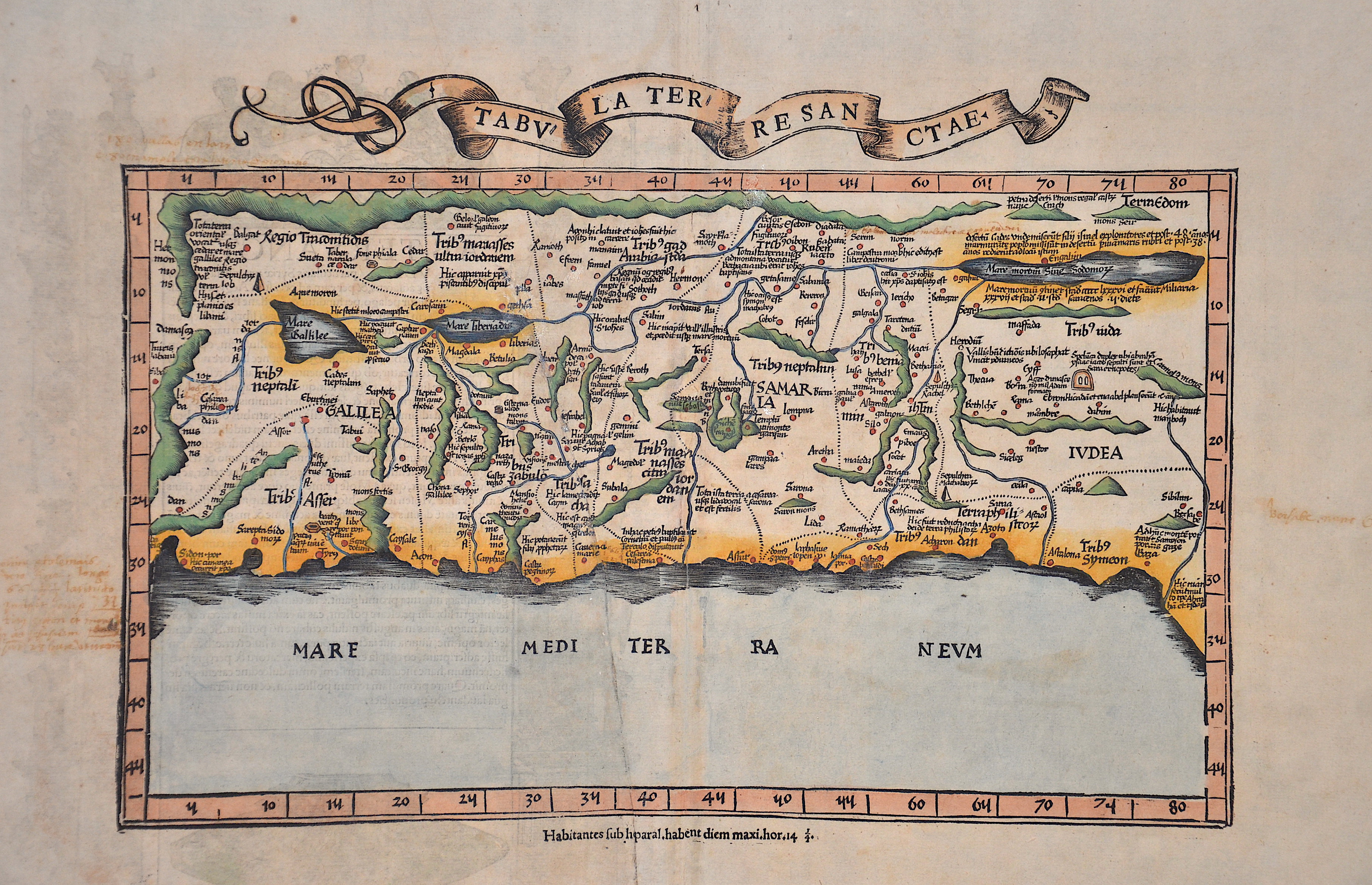
Tabula Terre Sanctae

| Article ID | ASP1351 |
Title | Tabula Terre Sanctae |
Description | Map shows the entire Holy Land with title loop. Back with description and magnificent decorations of columns and ornaments. Printed by M & G Trechsel. |
| Year | ca. 1535 |
Artist | Ptolemy/ Fries (1490-1531) |
Lorenz (Laurent) Fries was born in Alsace in 1490 or thereabouts, describing himself on one occasion as from Colmar, one of the towns of the region. He studied medicine at university, or rather at universities, as he seems to have had a peripatetic education, apparently spending time at the universities of Pavia, Piacenza, Montpellier and Vienna. Having successfully completed his education, Fries established himself as a physician, at a succession of places in the Alsace region, with a short spell in Switzerland, before settling in Strasbourg, in about 1519. By this time, he had established a reputation as a writer on medical topics, with several publications already to his credit. Indeed, it was thus that Fries met the Strasbourg printer and publisher Johann Grüninger, an associate of the St. Die group of scholars formed by, among others, Walter Lud, Martin Ringmann and Martin Waldseemuller. Gruninger was responsible for printing several of the maps prepared by Waldseemuller, and for supervising the cutting of the maps for the 1513 edition of Ptolemy, edited by the group. This meeting was to introduce a important digression into Fries' life, and for the next five years, from about 1520 to about 1525, he worked in some capacity as a cartographic editor with Gruninger, exploiting the corpus of material that Waldseemuller had created. The first edition of Ptolemy's Geographia editet by Fries was published in Strasbourg in 1522, with maps that were copied and re-engraved from those of Martin Waldseemüller of the 1520 edition of Ptolemy and text edited by Pirckheimer. In 1525 a second edition was printed in Strasbourg. At the death of Fries and Gruninger, the plates were purchased by the brother Melchior and Gaspar Treschel, who printed a thord edition in Lyon in 1535. For the text, the two editors used the supervision of Michael Servetus, who editet Pirckheimer's text. Finally, in 1541, Gaspare Treechsel published in Vienne, in the Dauphine, this fourth edition, again with Servetus' text. in this edition, compared to the first edition of Strasbourg in 1522, the text underwent numerous changes, corrections and additions, but the wood-Blocks were not changed. Claudius Ptolemy ( arround 100- 160 a.C.) Geographia, gives a list of geographic coordinates of spherical longitude and latitude of almost ten thousand point locations on the earth surface, as they were known at his times. The list is organized in Tabulae which cor- respond to specific regions of the three known continents at that time, Africa, Asia and Europe. Research on Ptolemy’s Geographia has started at the University of Thessaloniki, Greece, in the eighties, focused mainly, but not exclusively, on data re- lated to territories which are now under the sovereignty of the modern Greek state. The World of Ptolemy is classified in Regions, since each Chapter is referred to one of them, giving by this way the concept of Atlas as it is understood today. | |
Historical Description | The first archaeologically proven traces of an early or proto-Israelite settlement in the Mashrek region go back to the period between the 12th and 11th centuries BC. BC back. According to biblical tradition, Jerusalem was founded around 1000 BC. Conquered by David from the Jebusites and chosen as the capital of his great empire. The country subsequently became part of the Persian Empire, then the Empire of Alexander the Great, and finally the Empire of the Seleucids. The Maccabees revolt in 165 BC BC brought Israel once more state independence for about 100 years. 63 BC The time of Roman supremacy began. The Romans divided the area into two provinces: Syria in the north, Judea in the south. In the course of the Islamic expansion, the area came under Arab rule in 636. Since then, Palestine has been predominantly inhabited by Arabs. The crusaders ruled from 1099 to 1291 what they called the "Latin Kingdom of Jerusalem". This was followed by the Mamluks from 1291 to 1517 and then the Ottoman rule from 1517 to 1918. None of these authorities had planned their own administration for Palestine or viewed the area as an independent geographical unit. The region was also part of Syria for the Ottomans, probably going back to the Roman name Syria. |
| Place of Publication | Lyon |
| Dimensions (cm) | 29 x 41 cm |
| Condition | Tear on the left side perfectly restored |
| Coloring | original colored |
| Technique | Woodcut |