

Adina Sommer
Antique and Contemporary Art
Winzerer Str. 154
80797 München
telephone
+49 89 304714
business hours:
by appointment
Email
![]()


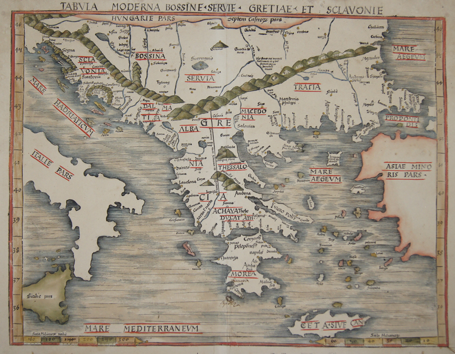
Tabula Moderna Bossine, Servie, Gretiae, et Sclavonie

| Article ID | EUK3041 |
Title | Tabula Moderna Bossine, Servie, Gretiae, et Sclavonie |
Description | Map shows the Balkans Peninsula with total Greece with the Pelepones and all greece islands.Partly Italy, Sicily and Turkey. Rivers and mountains are roughly shown in the country on the side the climatically zones. Ptolomey watermark on the left side ( Lilly). |
| Year | ca. 1513 |
Artist | Ptolemy/Waldseemüller- Johann Schott (1477-1550) |
Johann Schott (1477–1550) reissued Martin Waldseemüller’s maps, including 20 detailed regional maps in his atlas Tabula Moderna Germanie, making it one of the most important works of its time. Schott is also known for the atlases Alexandri Magni and Margarita philosophica. Martin Waldseemüller (born c. 1470s, Radolfzell, Germany) studied at Freiburg University and later moved to Lorraine, France, where he joined the intellectual circle Gymnasium Vosagense. He died in 1522. Waldseemüller created the 1507 wall map that first named America and completed maps for a 1513 edition of Ptolemy’s Geography. His atlas merged cartographic science with printing art and included 20 modern maps alongside Ptolemaic ones, using a new quadratic projection. Johannes Schott printed the atlas, with Waldseemüller providing the drawings. Editors Jacobus Äschler and George Uebel worked on the text. Supported by René, Duke of Lorraine, Waldseemüller developed new maps abandoning Ptolemy’s projection for rectilinear meridians and parallels. Due to the Duke’s death, printing was delayed until 1512. The atlas included 26 classical Ptolemaic maps plus 20 new ones published separately. The New World map was based on recent, reliable information attributed to “The Admiral,” believed to be Columbus, leading to the atlas being called the Admiral Atlas. Schott printed a version with minor corrections in Augsburg. Ptolemy’s Geographia (c. 100–160 AD) listed geographic coordinates for nearly 10,000 locations across Africa, Asia, and Europe, organized into regions—an early concept of an atlas. Research on this work, notably at the University of Thessaloniki, continues today. Most maps bear a watermark of a triple-pointed crown. | |
Historical Description | Greece is considered the cradle of Western civilisation, being the birthplace of democracy, Western philosophy, Western literature, historiography, political science, major scientific and mathematical principles, Western drama and the Olympic Games. From the eighth century B.C., the Greeks were organised into various independent city-states, known as poleis (singular polis), which spanned the entire Mediterranean region and the Black Sea. Philip of Macedon united most of the Greek mainland in the fourth century BC, with his son Alexander the Great rapidly conquering much of the ancient world, from the eastern Mediterranean to India. Greece was annexed by Rome in the second century B.C., becoming an integral part of the Roman Empire and its successor, the Byzantine Empire, which adopted the Greek language and culture. The Greek Orthodox Church, which emerged in the first century A.D., helped shape modern Greek identity and transmitted Greek traditions to the wider Orthodox World. After falling under Ottoman dominion in the mid-15th century, Greece emerged as a modern nation state in 1830 following a war of independence. |
| Place of Publication | Strassburg |
| Dimensions (cm) | 42,5 x 55 |
| Condition | Tear on upper and lower margin perfectly restored |
| Coloring | black/white |
| Technique | Woodcut |