

Adina Sommer
Antique and Contemporary Art
Winzerer Str. 154
80797 München
telephone
+49 89 304714
business hours:
by appointment
Email
![]()


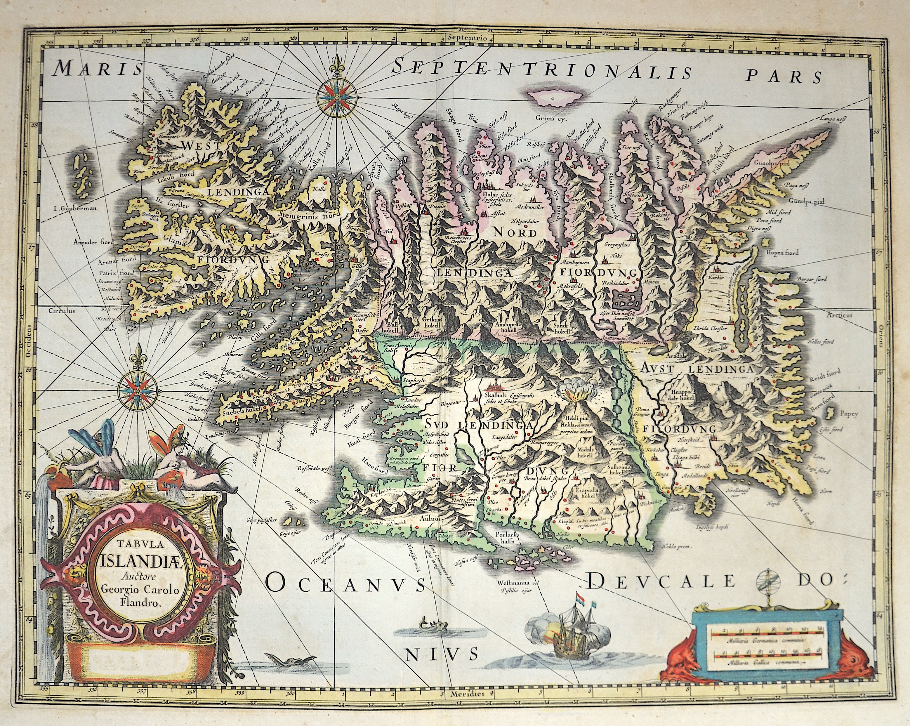
Tabula Islandiae Auctore Georgio Carolo Flandrol.

| Article ID | EUS3951 |
Title | Tabula Islandiae Auctore Georgio Carolo Flandrol. |
Description | A striking full color example of Iceland. A stunning map, including an erupting volcano, sea monsters, sailing ships, decorative cartouches, compass rose and the spectacular landscape of Iceland. Carolius used Mercator's version of Bishop Gudbrandur Thorlaksson's map as his source. Nice wide margined example, in striking color. A fine map of Iceland, based on a map by Joris Carl (1601-25), a pilot from Enkhuizen. It is decorated with an ornate title cartouche, a pair of compass roses, a galleon and seamonsters. This map is one of the symbols of the intense rivalry between Jansson and Blaeu. Joris Carl's map was first engraved by Jodocus Hondius II (son of the firm's founder and Jansson's brother-in-law). When Jodocus died in 1629 many of his plates were sold to Willem Blaeu, who added his name to the plates and used them to publish his first atlas in 1630. Angered by the sale, Jansson had the Hondius plates slavishly copied. This plate, which only differs from Blaeu's by the lack of his name under the title, was first issued the same year. The lack of text on verso suggests this could be the first issue, from the 'Atlantis Maioris Appendix'. KOEMAN: Me 31a. |
| Year | ca. 1635 |
Artist | Janssonius (1588-1664) |
Johannes Janssonius (Jansson)( 1588- 1664) Amsterdam, was born in Arnhem, the son of Jan Janszoon the Elder, a publisher and bookseller. In 1612 he married Elisabeth de Hondt, the daughter of Jodocus Hondius. He produced his first maps in 1616 of France and Italy. In 1623 Janssonius owned a bookstore in Frankfurt am Main, later also in Danzig, Stockholm, Copenhagen, Berlin, Königsberg, Geneva and Lyon. In the 1630s he formed a partnership with his brother in law Henricus Hondius, and together they published atlases as Mercator/Hondius/Janssonius. Under the leadership of Janssonius the Hondius Atlas was steadily enlarged. Renamed Atlas Novus, it had three volumes in 1638, one fully dedicated to Italy. 1646 a fourth volume came out with ""English County Maps"", a year after a similar issue by Willem Blaeu. Janssonius' maps are similar to those of Blaeu, and he is often accused of copying from his rival, but many of his maps predate those of Blaeu and/or covered different regions. By 1660, at which point the atlas bore the appropriate name ""Atlas Major"", there were 11 volumes, containing the work of about a hundred credited authors and engravers. It included a description of ""most of the cities of the world"" (Townatlas), of the waterworld (Atlas Maritimus in 33 maps), and of the Ancient World (60 maps). The eleventh volume was the Atlas of the Heavens by Andreas Cellarius. Editions were printed in Dutch, Latin, French, and a few times in German. | |
Historical Description | Iceland is a Nordic island country in the North Atlantic. Iceland is volcanically and geologically active. According to the ancient manuscript Landnámabók, the settlement of Iceland began in 874 AD when the Norwegian chieftain Ingólfr Arnarson became the first permanent settler on the island. In the following centuries, Norwegians, and to a lesser extent other Scandinavians, emigrated to Iceland, bringing with them thralls (i.e., slaves or serfs) of Gaelic origin. The island was governed as an independent commonwealth under the Althing, one of the world's oldest functioning legislative assemblies. Following a period of civil strife, Iceland acceded to Norwegian rule in the 13th century. The establishment of the Kalmar Union in 1397 united the kingdoms of Norway, Denmark, and Sweden. Iceland thus followed Norway's integration to that union and came under Danish rule, after Sweden's secession from that union in 1523. In the wake of the French Revolution and the Napoleonic Wars, Iceland's struggle for independence took form and culminated in independence in 1918 and the founding of a republic in 1944. Until the 20th century, Iceland relied largely on subsistence fishing and agriculture, and was among the poorest countries in Europe. |
| Place of Publication | Amsterdam |
| Dimensions (cm) | 38 x 49,5 cm |
| Condition | Some folds |
| Coloring | original colored |
| Technique | Copper print |