

Adina Sommer
Antique and Contemporary Art
Winzerer Str. 154
80797 München
telephone
+49 89 304714
business hours:
by appointment
Email
![]()


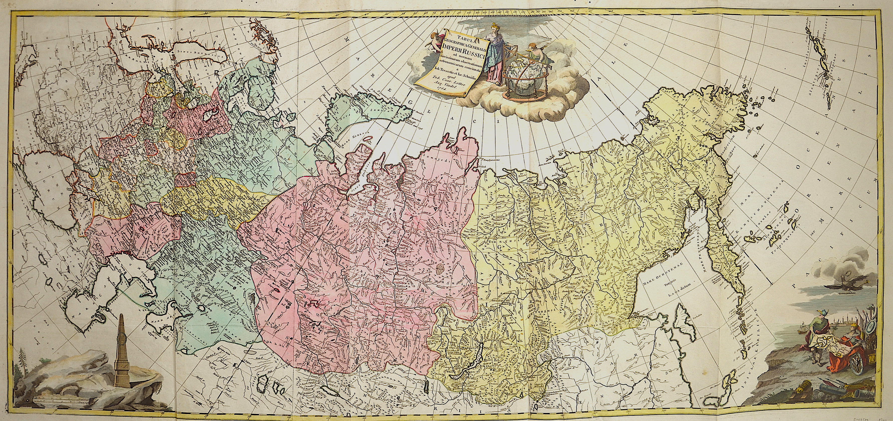
Tabula Geographica Generalis Imperii Russici ad normam novis sinarum observationum astronomiearum concinnata.

| Article ID | EUO3519 |
Title | Tabula Geographica Generalis Imperii Russici ad normam novis sinarum observationum astronomiearum concinnata. |
Description | Map shows total Russia from Lithuania and Poland in the west to the Pacific Ocean and the Aleutian Islands in the east. The map is based upon the work of Johann Treskot and Johann Schmidt. Their 23-sheet survey of Russia was completed in 1776 for the Imperial Academy of Sciences. Johann Treskot, member of the geographical Department of the St Petersburg Academy of Sciences, 1742. He compiled many of the maps published by the Academy, one of this, is the ;Tabula geographica Imperii Russici. This map has been published by Conrad Lotter. |
| Year | dated 1784 |
Artist | Treskot/ Schmidt (1719-1786) |
Johann Treskot, member of the geographical Department of the St Petersburg Academy of Sciences, 1742. He compiled many of the maps published by the Academy, one of this, is the "Tabula geographica Imperii Russici". | |
Historical Description | The East Slavs, emerged as a recognizable group in Europe between the 3rd and 8th centuries AD. founded and ruled by a Varangianwarrior elite and their descendants, the medieval state of Rus arose in the 9th century. In 988 it adopted Orthodox Christianity from the Byzantine Empire, beginning the synthesis of Byzantine and Slavic cultures that defined Russian culture for the next millennium. Rus ultimately disintegrated into a number of smaller states; most of the Rus' lands were overrun by the Mongol invasion and became tributaries of the nomadic Golden Horde in the 13th century. The Grand Duchy of Moscow gradually reunified the surrounding Russian principalities and achieved independence from the Golden Horde. By the 18th century, the nation had greatly expanded through conquest, annexation, and exploration to become the Russian Empire, which was the third largest empire in history, stretching from Poland on the west to Alaska on the east. In classical antiquity, the Pontic Steppe was known as Scythia. Beginning in the 8th century BC, Ancient Greek traders brought their civilization to the trade emporiums in Tanais and Phanagoria. Ancient Greek explorers, most notably Pytheas, even went as far as modern day Kaliningrad, on the Baltic Sea. Romans settled on the western part of the Caspian Sea, where their empire stretched towards the east. The establishment of the first East Slavic states in the 9th century coincided with the arrival of Varangians, the traders, warriors and settlers from the Baltic Sea region. Primarily they were Vikings of Scandinavian origin, who ventured along the waterways extending from the eastern Baltic to the Blackand Caspian Seas. In the 10th to 11th centuries Kievan Rus' became one of the largest and most prosperous states in Europe. Galicia-Volhynia was eventually assimilated by the Kingdom of Poland, while the Mongol-dominated Vladimir-Suzdal and Novgorod Republic, two regions on the periphery of Kiev, established the basis for the modern Russian nation. The most powerful state to eventually arise after the destruction of Kievan Rus' was the Grand Duchy of Moscow. Times remained difficult, with frequent Mongol-Tatar raids. Led by Prince Dmitry Donskoy of Moscow and helped by the Russian Orthodox Church, the united army of Russian principalities inflicted a milestone defeat on the Mongol-Tatars in the Battle of Kulikovo in 1380. Moscow gradually absorbed During his long reign, Ivan the Terrible nearly doubled the already large Russian territory by annexing the three Tatar khanates, Kazan and Astrakhan along the Volga River, and the Siberian Khanate in southwestern Siberia. However, the Tsardom was weakened by the long and unsuccessful Livonian War against the coalition of Poland, Lithuania, and Sweden for access to the Baltic coast and sea trade. The death of Ivan's sons marked the end of the ancient Rurik Dynasty in 1598. The Polish–Lithuanian Commonwealth occupied parts of Russia, including Moscow. In 1612, the Poles were forced to retreat by the Russian volunteer corps. The Romanov Dynasty acceded to the throne in 1613. Russia continued its territorial growth through the 17th century, which was the age of Cossacks. Cossacks were warriors organized into military communities, resembling pirates and pioneers of the New World. Under Peter the Great, Russia was proclaimed an Empire in 1721 and became recognized as a world power. Ruling from 1682 to 1725, Peter defeated Sweden in the Great Northern War, forcing it to cede West Karelia and Ingria, as well as Estland and Livland, securing Russia's access to the sea and sea trade. On the Baltic Sea, Peter founded a new capital called Saint Petersburg, later known as Russia's "window to Europe". Peter the Great's reforms brought considerable Western European cultural influences to Russia. Catherine II who ruled in 1762–96, presided over the Age of Russian Enlightenment. In 1803–1806, the first Russian circumnavigation was made, later followed by other notable Russian sea exploration voyages. In 1820, a Russian expedition discovered the continent of Antarctica. n alliances with various European countries, Russia fought against Napoleon's France. The French invasion of Russia at the height of Napoleon's power in 1812 reached Moscow. The Russian army ousted Napoleon from the country and drove through Europe in the war of the Sixth Coalition, finally entering Paris. Alexander I headed Russia's delegation at the Congress of Vienna that defined the map of post-Napoleonic Europe. The late 19th century saw the rise of various socialist movements in Russia. The last Russian Emperor was Nicholas II (1894–1917). |
| Place of Publication | Augsburg |
| Dimensions (cm) | 63,5 x 139 |
| Condition | Printed on 3 sheets joined together, stains left |
| Coloring | original colored |
| Technique | Copper print |