

Adina Sommer
Antique and Contemporary Art
Winzerer Str. 154
80797 München
telephone
+49 89 304714
business hours:
by appointment
Email
![]()


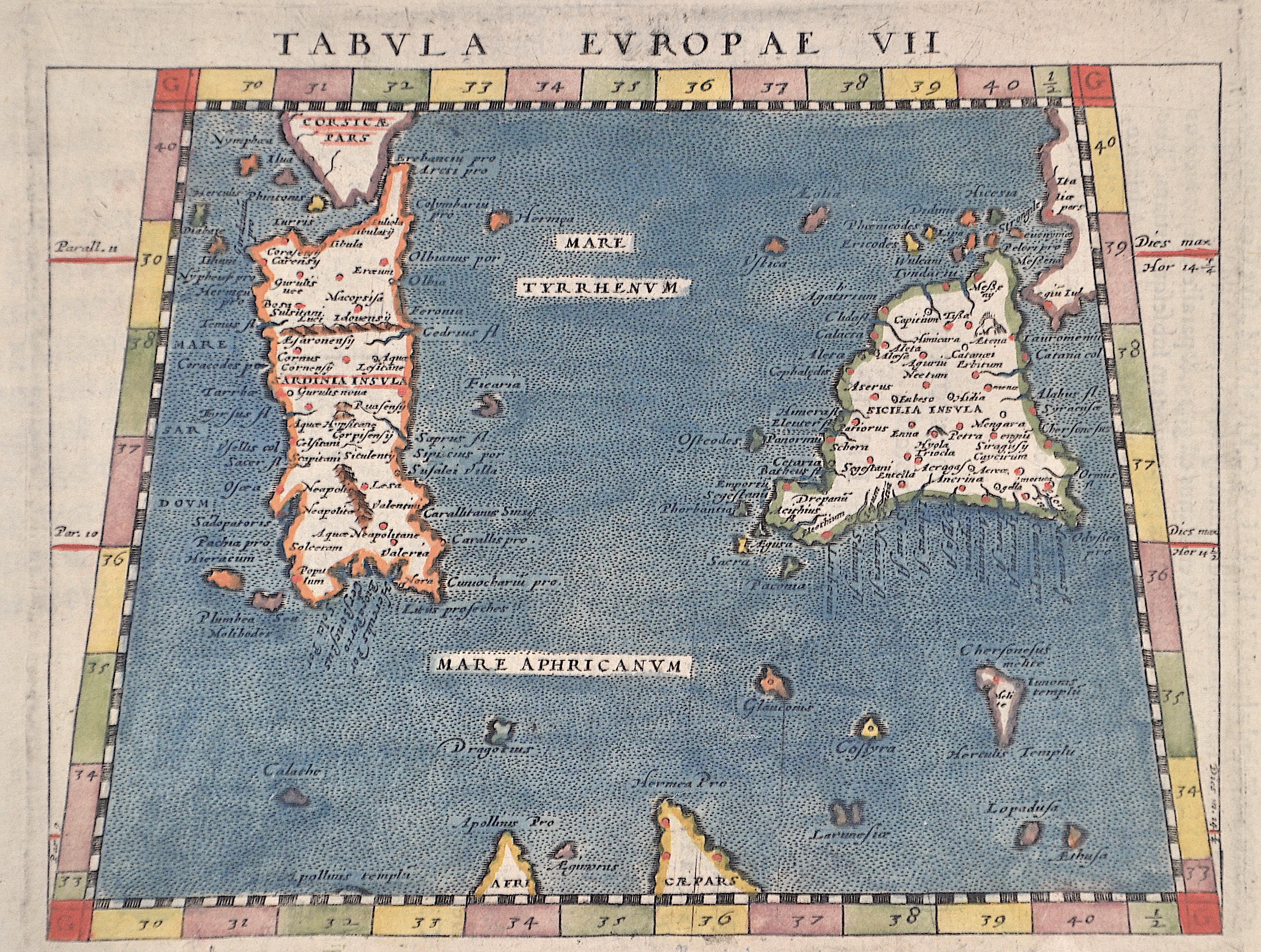
Tabula Europae VII

| Article ID | EUI4911 |
Title | Tabula Europae VII |
Description | The trapezoidal map shows the Mediterranean Sea with the islands of Sardinia, Sicily, Malta and many surrounding islands. |
| Year | ca. 1600 |
Artist | Magini (1555-1617) |
Giovanni Antonio Magini was an Italian astronomer and mathematician. In 1592 he published De Planis Triangulis, where he described the use of the quadrants. In 1607 he published the astrological work De astrologica ratione. Magini also created an atlas of Italy (Atlante geografico d'Italia), which, however, was not published by his son until 1620. In 1935 the lunar crater Maginus was named after him. | |
Historical Description | It is believed that the Sherds, often referred to as Shardana, a "sea people" coming from the eastern Mediterranean and known from Egyptian sources, settled here around 1200 BC. The Phoenician-Punic period in Sardinia began in the 9th century B.C. Since the 14th century B.C., Sardinia has been visited by seafarers from the eastern Mediterranean. Mycenaeans and Cypriots were already trading with the island at that time. Etruscan-Phoenician trade was also conducted in Sardinia from the 7th century. Following in the footsteps of the Levantine traders were the Punic, who were particularly interested in the ore deposits of Iglesiente. They founded not only trading posts in places like Karali (today Cagliari), and Othoca , Nora, Sulki ( Sulcis), Su Fraigu and Tharros, but also colonies. By the middle of the 6th century BC, the Punic had taken control of the south and west of Sardinia. They then began to transform their part of the island into a granary. Punic and Sardinian combined into one culture in the occupied territory from the 3rd century BC. The triangle of Ibiza, Corsica (including Sardinia) and Sicily represented, according to today's knowledge, the overseas continuation of the Carthaginian motherland. During the First Punic War, Rome had felt the strategic importance of Sardinia. After unsuccessful attempts to take control of the island, Rome had to recognize Carthage's sovereign rights over Sardinia in the peace treaty of 241 BC. Until the First Punic War, the Punic inhabitants of Carthage were nominally the masters of the island, although they never advanced into the interior, which was still largely autonomous well into Roman times (from 238 BC). With the conquest of Sulcis in 704, a period of more than two hundred years began in which the Arabs repeatedly raided the island's coasts. A large part of the coastal population fled to the interior of the island. The now isolated island was divided from the 9th century into four giudicati with local feudal rulers - "judges". The Arab fleets dominated the coasts. A permanent Arab conquest was prevented until 1014/15. The Hohenstaufen Frederick II (1198-1250), King of Sicily, appointed his illegitimate son Enzio King of Sardinia in 1239, from which came the island's status as a kingdom, which remained until its absorption into the Kingdom of Italy in 1861. After the extinction of the Spanish Habsburgs, Sardinia fell to the Austrian line of the House of Habsburg following the War of the Spanish Succession in 1714, but was ceded to the ruling House of Savoy as early as 1720. The newly created Kingdom of Sardinia, with its capital Turin and its provinces of Savoy and Piedmont, now had its geographical center on the Italian mainland. It was not until 1946 that the island received autonomy as the Autonomous Region of Sardinia. |
| Place of Publication | Venice |
| Dimensions (cm) | 13 x 17 cm |
| Condition | Perfect condition |
| Coloring | original colored |
| Technique | Copper print |