

Adina Sommer
Antique and Contemporary Art
Winzerer Str. 154
80797 München
telephone
+49 89 304714
business hours:
by appointment
Email
![]()


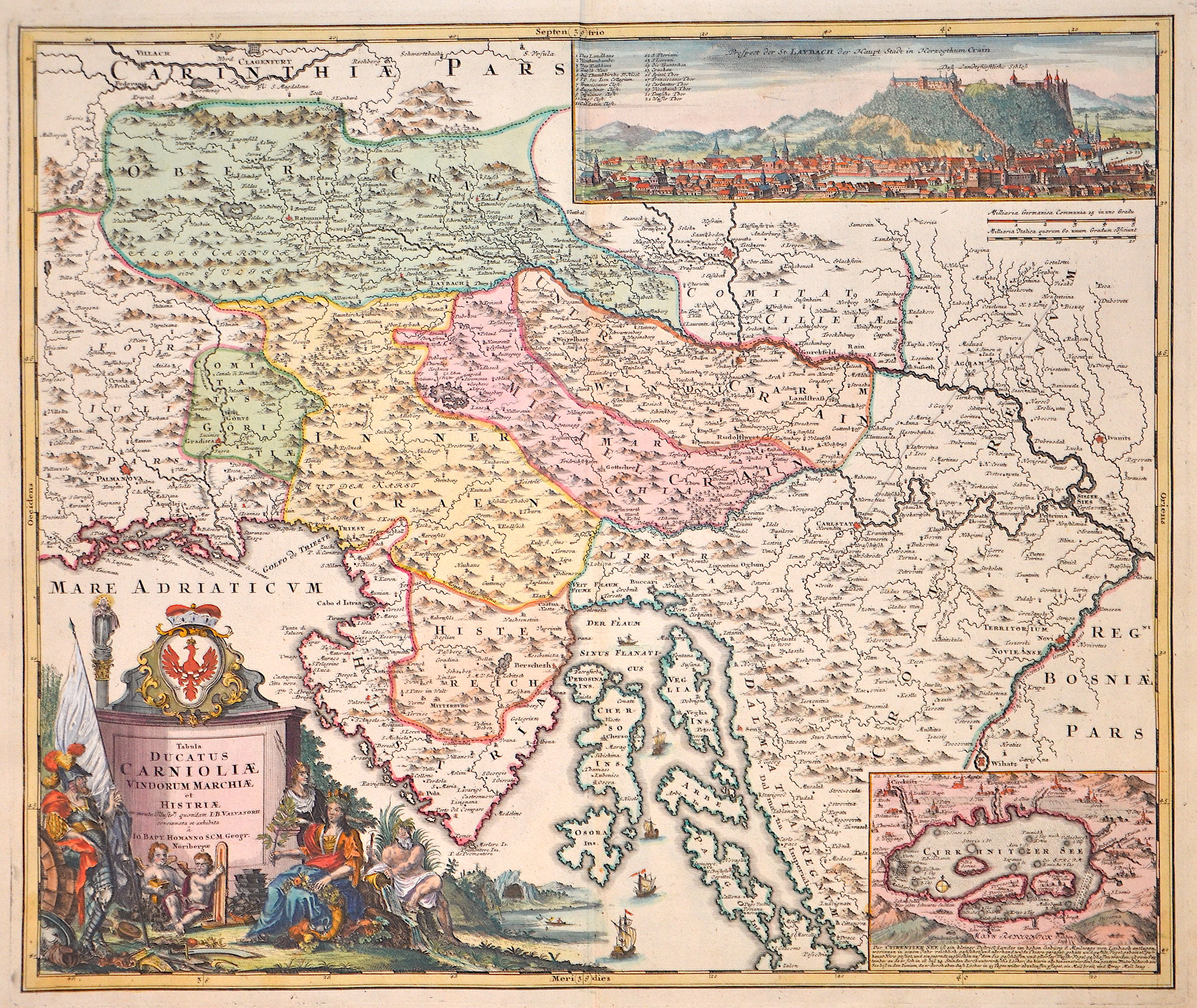
Tabula ducatus Carnioliae Vindurum Marchiae et Histriae

| Article ID | EUY1244 |
Title | Tabula ducatus Carnioliae Vindurum Marchiae et Histriae |
Description | Map shows Slovenia with e.g. the towns of Kranj, Celje, Ljublijana. Furthermore, Istria and the northern part of Croatia with the cities of Zagreb (Agram) Karlovak, Sisak, Ivanić-Grad (Ivanitz) and Senj. At the bottom left a magnificent title cartouche with allegorical depictions and a coat of arms, at the top right a general view of the town of Laybach (Ljublijana) with index. At the bottom right a partial map of Lake Zirknica with its surroundings and a description. |
| Year | ca. 1710 |
Artist | Homann (1664-1724) |
Johann Babtiste Homann (1664-1724), Nuremberg, was born in Oberkammlach, the Electorate of Bavaria. Although educated at a Jesuit school, and preparing for an ecclesiastical career, he eventually converted to Protestantism and from 1687 worked as a civil law notary in Nuremberg. He soon turned to engraving and cartography; in 1702 he founded his own publishing house. Homann acquired renown as a leading German cartographer, and in 1715 was appointed Imperial Geographer by Emperor Charles VI. Giving such privileges to individuals was an added right that the Holy Roman Emperor enjoyed. In the same year he was also named a member of the Prussian Academy of Sciences in Berlin. Of particular significance to cartography were the imperial printing privileges (Latin: privilegia impressoria). These protected for a time the authors in all scientific fields such as printers, copper engravers, map makers and publishers. They were also very important as a recommendation for potential customers. In 1716 Homann published his masterpiece Grosser Atlas ueber die ganze Welt (Grand Atlas of all the World). Numerous maps were drawn up in cooperation with the engraver Christoph Weigel the Elder, who also published Siebmachers Wappenbuch. Homann died in Nuremberg. He was succeeded by the Homann heirs company, which was in business until 1848. The company was known as Homann Erben, Homanniani Heredes, or Heritiers de Homann abroad. | |
Historical Description | The Carantanians, one of the ancestral groups of the modern Slovenes, particularly the Carinthian Slovenes, were the first Slavic people to accept Christianity. In the mid-8th century, Carantania became a vassal duchy under the rule of the Bavarians, who began spreading Christianity. Three decades later, the Carantanians were incorporated, together with the Bavarians, into the Carolingian Empire. During the same period Carniola, too, came under the Franks, and was Christianised from Aquileia. Following the anti-Frankish rebellion of Liudewit at the beginning of the 9th century, the Franks removed the Carantanian princes, replacing them with their own border dukes. Consequently, the Frankish feudal system reached the Slovene territory. By the late Middle Ages, the historic provinces of Carniola, Styria, Carinthia, Gorizia, Trieste, and Istria developed from the border regions and were incorporated into the medieval German state. In the 14th century, most of the territory of present-day Slovenia was taken over by the Habsburgs. The counts of Celje, a feudal family from this area who in 1436 acquired the title of state princes, were Habsburgs' powerful competitors for some time. This large dynasty, important at a European political level, had its seat in Slovene territory but died out in 1456. Its numerous large estates subsequently became the property of the Habsburgs, who retained control of the area right up until the beginning of the 20th century. Patria del Friuli ruled present western Slovenia until Venetian takeover in 1420. The Republic of Venice was dissolved by France and Venetian Slovenia was passed to the Austrian Empire in 1797. The Slovene Lands were part of the French-administered Illyrian provinces established by Napoleon, the Austrian Empire and Austria-Hungary. Slovenes inhabited most of Carniola, the southern part of the duchies of Carinthia and Styria, the northern and eastern areas of the Austrian Littoral, as well as Prekmurje in the Kingdom of Hungary. |
| Place of Publication | Nuremberg |
| Dimensions (cm) | 48 x 57 cm |
| Condition | Perfect condition |
| Coloring | original colored |
| Technique | Copper print |