

Adina Sommer
Antique and Contemporary Art
Winzerer Str. 154
80797 München
telephone
+49 89 304714
business hours:
by appointment
Email
![]()


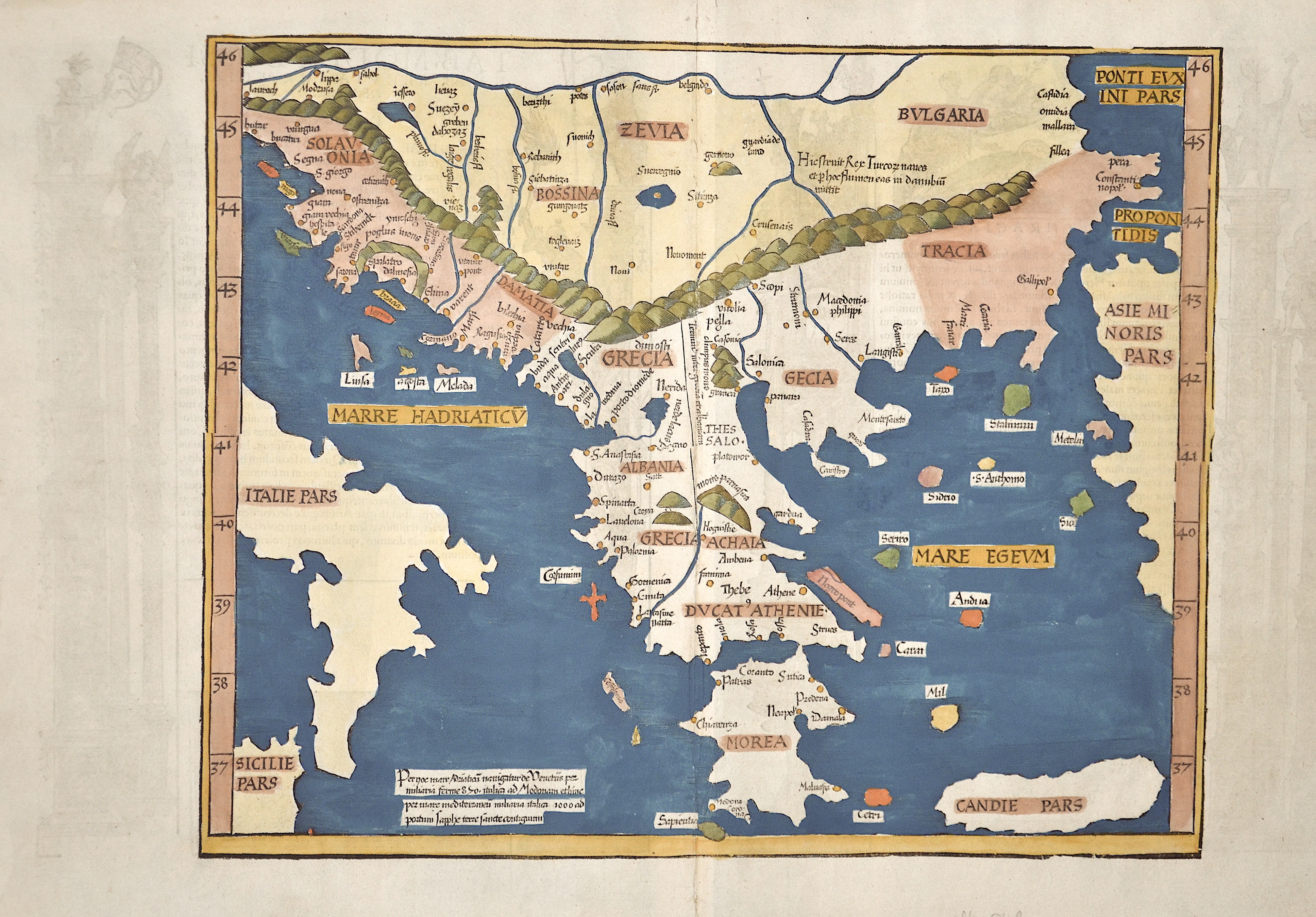
Tab. Moder. Bossinae, Serviae, kGraeciae & Sclavoniae. Et primo de Graecia.

| Article ID | EUK4395 |
Title | Tab. Moder. Bossinae, Serviae, kGraeciae & Sclavoniae. Et primo de Graecia. |
Description | Map shows the Balkan Peninsula with all of Greece, the Pelepones and the Greek Islands, some of Italy, Sicily and Turkey. Roughly list in the country, mountains and rivers. Back with text and ornaments. |
| Year | ca. 1525 |
Artist | Ptolemy/ Fries (1490-1531) |
Lorenz (Laurent) Fries was born in Alsace in 1490 or thereabouts, describing himself on one occasion as from Colmar, one of the towns of the region. He studied medicine at university, or rather at universities, as he seems to have had a peripatetic education, apparently spending time at the universities of Pavia, Piacenza, Montpellier and Vienna. Having successfully completed his education, Fries established himself as a physician, at a succession of places in the Alsace region, with a short spell in Switzerland, before settling in Strasbourg, in about 1519. By this time, he had established a reputation as a writer on medical topics, with several publications already to his credit. Indeed, it was thus that Fries met the Strasbourg printer and publisher Johann Grüninger, an associate of the St. Die group of scholars formed by, among others, Walter Lud, Martin Ringmann and Martin Waldseemuller. Gruninger was responsible for printing several of the maps prepared by Waldseemuller, and for supervising the cutting of the maps for the 1513 edition of Ptolemy, edited by the group. This meeting was to introduce a important digression into Fries' life, and for the next five years, from about 1520 to about 1525, he worked in some capacity as a cartographic editor with Gruninger, exploiting the corpus of material that Waldseemuller had created. The first edition of Ptolemy's Geographia editet by Fries was published in Strasbourg in 1522, with maps that were copied and re-engraved from those of Martin Waldseemüller of the 1520 edition of Ptolemy and text edited by Pirckheimer. In 1525 a second edition was printed in Strasbourg. At the death of Fries and Gruninger, the plates were purchased by the brother Melchior and Gaspar Treschel, who printed a thord edition in Lyon in 1535. For the text, the two editors used the supervision of Michael Servetus, who editet Pirckheimer's text. Finally, in 1541, Gaspare Treechsel published in Vienne, in the Dauphine, this fourth edition, again with Servetus' text. in this edition, compared to the first edition of Strasbourg in 1522, the text underwent numerous changes, corrections and additions, but the wood-Blocks were not changed. Claudius Ptolemy ( arround 100- 160 a.C.) Geographia, gives a list of geographic coordinates of spherical longitude and latitude of almost ten thousand point locations on the earth surface, as they were known at his times. The list is organized in Tabulae which cor- respond to specific regions of the three known continents at that time, Africa, Asia and Europe. Research on Ptolemy’s Geographia has started at the University of Thessaloniki, Greece, in the eighties, focused mainly, but not exclusively, on data re- lated to territories which are now under the sovereignty of the modern Greek state. The World of Ptolemy is classified in Regions, since each Chapter is referred to one of them, giving by this way the concept of Atlas as it is understood today. | |
Historical Description | Greece is considered the cradle of Western civilisation, being the birthplace of democracy, Western philosophy, Western literature, historiography, political science, major scientific and mathematical principles, Western drama and the Olympic Games. From the eighth century B.C., the Greeks were organised into various independent city-states, known as poleis (singular polis), which spanned the entire Mediterranean region and the Black Sea. Philip of Macedon united most of the Greek mainland in the fourth century BC, with his son Alexander the Great rapidly conquering much of the ancient world, from the eastern Mediterranean to India. Greece was annexed by Rome in the second century B.C., becoming an integral part of the Roman Empire and its successor, the Byzantine Empire, which adopted the Greek language and culture. The Greek Orthodox Church, which emerged in the first century A.D., helped shape modern Greek identity and transmitted Greek traditions to the wider Orthodox World. After falling under Ottoman dominion in the mid-15th century, Greece emerged as a modern nation state in 1830 following a war of independence. |
| Dimensions (cm) | 32 x 40 cm |
| Condition | Perfect condition |
| Coloring | original colored |
| Technique | Woodcut |