

Adina Sommer
Antique and Contemporary Art
Winzerer Str. 154
80797 München
telephone
+49 89 304714
business hours:
by appointment
Email
![]()


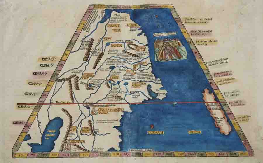
Ta superioris Indiae et Tartariae maioris

| Article ID | ASC0550 |
Title | Ta superioris Indiae et Tartariae maioris |
Description | The map shows the whole of China, including Japan (Zinpangri), and features a magnificent figurative depiction of the Tatar Khan in a tented camp. On the reverse is a text framed by ornate woodcut panels in the Renaissance style. |
| Year | ca. 1535 |
Artist | Ptolemy/ Fries (1490-1531) |
Lorenz (Laurent) Fries was born in Alsace in 1490 or thereabouts, describing himself on one occasion as from Colmar, one of the towns of the region. He studied medicine at university, or rather at universities, as he seems to have had a peripatetic education, apparently spending time at the universities of Pavia, Piacenza, Montpellier and Vienna. Having successfully completed his education, Fries established himself as a physician, at a succession of places in the Alsace region, with a short spell in Switzerland, before settling in Strasbourg, in about 1519. By this time, he had established a reputation as a writer on medical topics, with several publications already to his credit. Indeed, it was thus that Fries met the Strasbourg printer and publisher Johann Grüninger, an associate of the St. Die group of scholars formed by, among others, Walter Lud, Martin Ringmann and Martin Waldseemuller. Gruninger was responsible for printing several of the maps prepared by Waldseemuller, and for supervising the cutting of the maps for the 1513 edition of Ptolemy, edited by the group. This meeting was to introduce a important digression into Fries' life, and for the next five years, from about 1520 to about 1525, he worked in some capacity as a cartographic editor with Gruninger, exploiting the corpus of material that Waldseemuller had created. The first edition of Ptolemy's Geographia editet by Fries was published in Strasbourg in 1522, with maps that were copied and re-engraved from those of Martin Waldseemüller of the 1520 edition of Ptolemy and text edited by Pirckheimer. In 1525 a second edition was printed in Strasbourg. At the death of Fries and Gruninger, the plates were purchased by the brother Melchior and Gaspar Treschel, who printed a thord edition in Lyon in 1535. For the text, the two editors used the supervision of Michael Servetus, who editet Pirckheimer's text. Finally, in 1541, Gaspare Treechsel published in Vienne, in the Dauphine, this fourth edition, again with Servetus' text. in this edition, compared to the first edition of Strasbourg in 1522, the text underwent numerous changes, corrections and additions, but the wood-Blocks were not changed. Claudius Ptolemy ( arround 100- 160 a.C.) Geographia, gives a list of geographic coordinates of spherical longitude and latitude of almost ten thousand point locations on the earth surface, as they were known at his times. The list is organized in Tabulae which cor- respond to specific regions of the three known continents at that time, Africa, Asia and Europe. Research on Ptolemy’s Geographia has started at the University of Thessaloniki, Greece, in the eighties, focused mainly, but not exclusively, on data re- lated to territories which are now under the sovereignty of the modern Greek state. The World of Ptolemy is classified in Regions, since each Chapter is referred to one of them, giving by this way the concept of Atlas as it is understood today. | |
Historical Description | During the Qin Dynasty of the first emperor Qin Shihuangdi, much was unified, thus laying the foundations for a common cultural identity, including the Chinese script, consisting of thousands of Chinese characters, which is considered to be the oldest still used writing system in the world. According to the myth, China's history spans 5000 years, in which Chinese culture and science, especially Chinese languages, Chinese names, Chinese philosophy, Chinese cuisine, Chinese folk belief and traditional Chinese medicine have developed. However, the historical influence of Chinese traditions and cultural practices has not been confined to this narrow definition, as it has also spread to other Southeast Asian countries like Thailand, Myanmar, Singapore, Malaysia, Indonesia, Cambodia, Laos, Philippines, etc, through the establishment of overseas Chinese communities. The East Asian cultural sphere shares a Confucian ethical philosophy, Buddhism, Taoism, and it historically has shared a 3,000-year-old ancient Han Chinese writing system. The core regions of the East Asian cultural sphere are generally taken to be Greater China, Japan, Korea, and Vietnam. Chinese music, Chinese literature, Chinese painting, Chinese architecture, Chinese garden art and Chinese martial arts are typical of the style of Chinese art. |
| Place of Publication | Lyon |
| Dimensions (cm) | 29 x 45,5 cm |
| Condition | Restoration at centerfold, upper middle margin perfectly replaced |
| Coloring | original colored |
| Technique | Copper print |