

Adina Sommer
Antique and Contemporary Art
Winzerer Str. 154
80797 München
telephone
+49 89 304714
business hours:
by appointment
Email
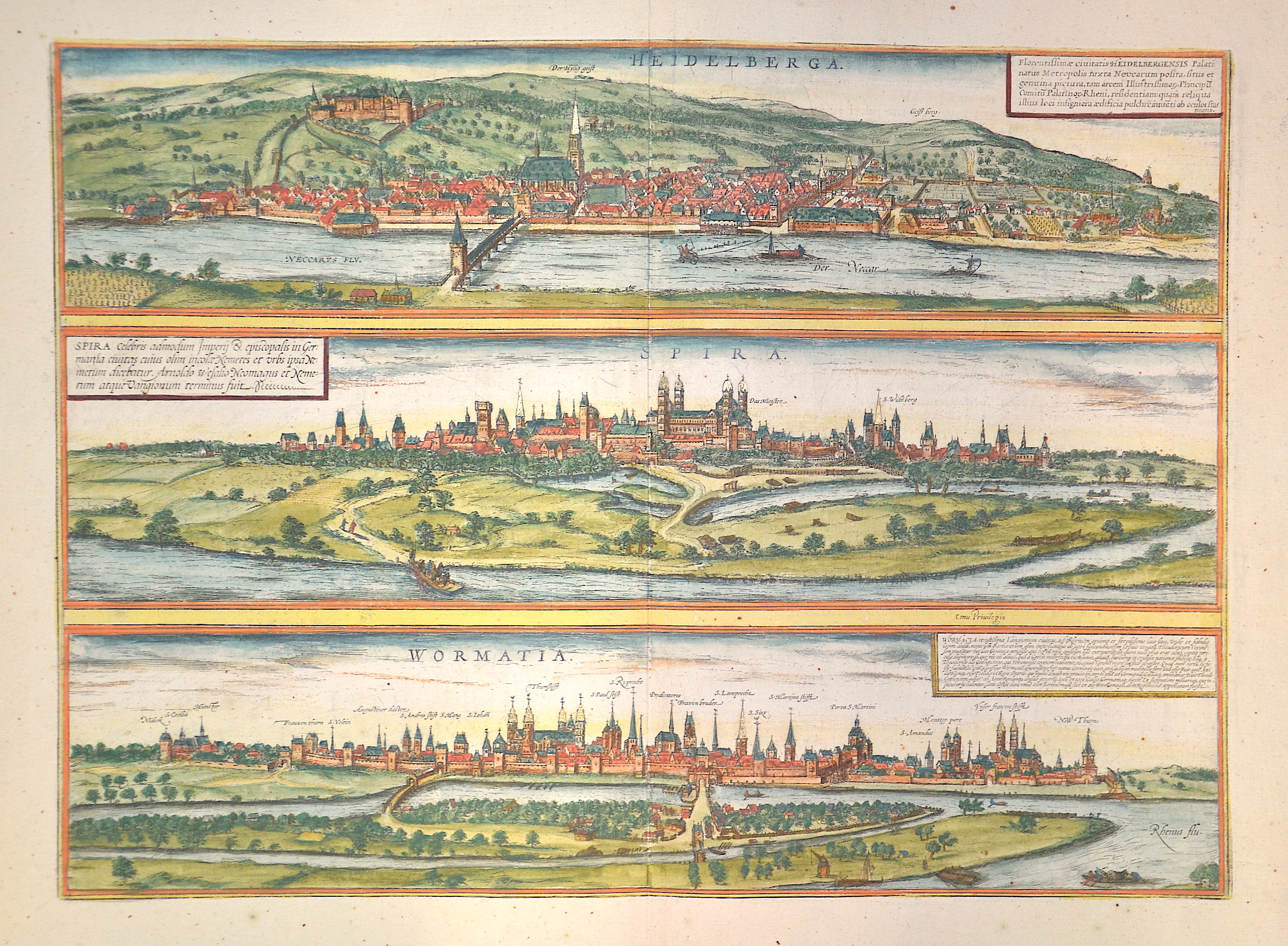
![]()


Spira/ Wormatia/Heidelberga

| Article ID | EUD1472 |
Title | Spira/ Wormatia/Heidelberga |
Description | The map shows the cities of Speyer and Worms in Rhineland-Palatinate and Heidelberg in Baden-Württemberg. |
| Year | ca. 1595 |
Artist | Braun/Hogenberg (1572-1618) |
Frans Hogenberg (1535 – 1590) was a Flemish and German painter, engraver, and mapmaker. Hogenberg was born in Mechelen as the son of Nicolaas Hogenberg In 1568 he was banned from Antwerp by the Duke of Alva. He travelled to London, where he stayed a few years before emigrating to Cologne. He is known for portraits and topographical views as well as historical allegories. He also produced scenes of contemporary historical events. George Braun (1541-1622), a cleric of Cologne, was the principal editor of the "Civitates Orbis Terrarum". The first volume of the Civitates Orbis Terrarum was published in Cologne in 1572. The sixth and the final volume appeared in 1617. This great city atlas, edited by Georg Braun and largely engraved by Franz Hogenberg, eventually contained 546 prospects, bird-eye views and map views of cities from all over the world. Braun (1541-1622), a cleric of Cologne, was the principal editor of the work, and was greatly assisted in his project by the close, and continued interest of Abraham Ortelius, whose Theatrum Orbis Terrarum of 1570 was, as a systematic and comprehensive collection of maps of uniform style, the first true atlas. | |
Historical Description | Baden-Wuertemberg is a state in southwest Germany, east of the Rhine, which forms the border with France. It is is formed from the historical territories of Baden, Prussian Hohenzollern, and Württemberg, and also parts of Swabia. Baden Würtemberg was only founded in 1952 by the merger of the states of Württemberg-Baden, Baden and Württemberg-Hohenzollern. Today the most populous city of Baden-Württemberg is the state capital Stuttgart, followed by Karlsruhe and Mannheim. Other major cities are Freiburg im Breisgau, Heidelberg, Ulm, Heilbronn, Pforzheim and Reutlingen. The early modern period was marked by the Reformation and the expansion efforts of the emerging states of Austria, Prussia, France and Sweden. Conflicts such as the Peasant War, the Thirty Years' War and the Palatinate War of Succession resulted from these. One of the focal points of the fighting, with corresponding consequences for the population and the economy, was in what is today Baden-Württemberg, which remained extremely fragmented territorially. At the beginning of the 19th century, around 300 states still had territorial rights in what is now Baden-Württemberg, but their number was reduced to four after the dissolution of the Old Empire. The Kingdom of Württemberg and the Grand Duchy of Baden were among the winners of the coalition wars. The two principalities of Hohenzollern-Sigmaringen and Hohenzollern-Hechingen survived mediatization due to their special relationship with Napoléon. In 1849, the Baden Revolution was put down by Prussian intervention forces, the Baden army was dissolved and rebuilt under Prussian leadership. In 1850 the two Hohenzollern states became the Prussian province of Hohenzollernsche Lande. With the new formation of the tribal duchies, the southern areas of what is now the state of Baden-Württemberg belonged to the Duchy of Swabia until the end of the High Middle Ages, the northern areas were located with the Duchy of Franconia. |
| Place of Publication | Cologne |
| Dimensions (cm) | 34,5 x 47 cm |
| Condition | Very good |
| Coloring | original colored |
| Technique | Copper print |