

Adina Sommer
Antique and Contemporary Art
Winzerer Str. 154
80797 München
telephone
+49 89 304714
business hours:
by appointment
Email
![]()


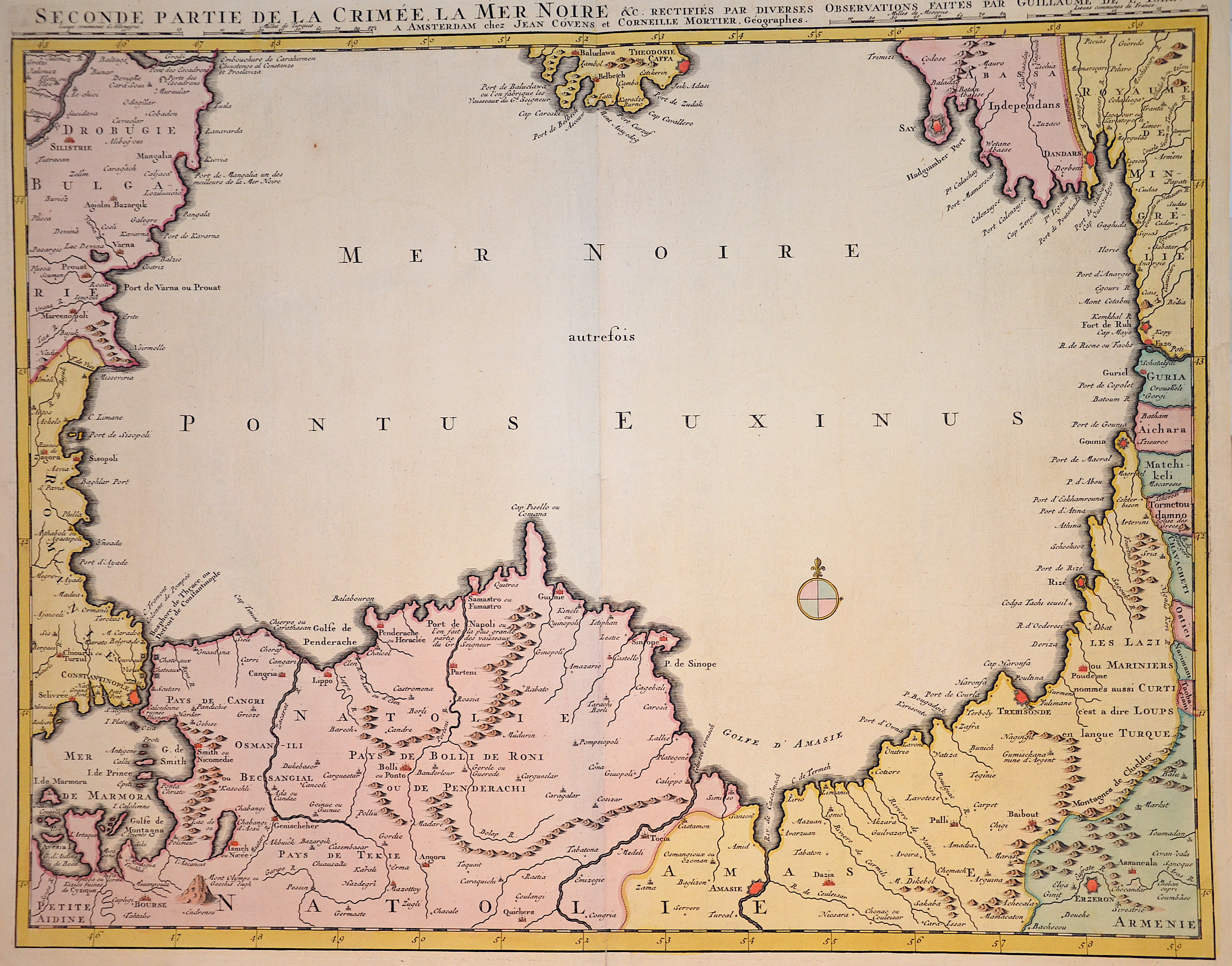
Seconde Partie de la Crimee La Mer Noir

| Article ID | EUO2235 |
Title | Seconde Partie de la Crimee La Mer Noir |
Description | Map shows the entire Black Sea with its surrounding countries and a compass rose. |
| Year | ca. 1720 |
Artist | L´Isle, de /Covens & Mortier (1675-1726) |
Guillaume De L’Isle (1675–1726) was a renowned French cartographer famous for his accurate maps of Europe, the Americas, and Africa. He joined the French Académie Royale des Sciences, signing his maps as “Géographe de l’Académie,” and later became Premier Géographe du Roi in 1718, teaching geography to the Dauphin. De L’Isle mostly worked from his office, relying on a strong network of traveler reports and scientific updates, ensuring his maps were precise and honest. He openly noted uncertain information, such as a disputed river in Louisiana. In 1700, he won a legal case against Jean-Baptiste Nolin for plagiarism. Unlike the Sanson workshop, which often published outdated maps, De L’Isle focused on up-to-date, scientifically grounded cartography. | |
Historical Description | Neanderthal settlement in Ukraine is seen in the Molodova archaeological sites, which include a mammoth bone dwelling. The territory is also considered to be the likely location for the human domestication of the horse. In the mid-14th century, upon the death of Bolesław Jerzy II of Mazovia, king Casimir III of Poland initiated campaigns (1340–1366) to take Galicia-Volhynia. Meanwhile, the heartland of Rus', including Kiev, became the territory of the Grand Duchy of Lithuania, ruled by Gediminas and his successors, after the Battle on the Irpen' River. In 1648, Bohdan Khmelnytsky and Petro Doroshenko led the largest of the Cossack uprisings against the Commonwealth and the Polish king John II Casimir. After Khmelnytsky made an entry into Kiev in 1648, where he was hailed liberator of the people from Polish captivity, he founded the Cossack Hetmanate which existed until 1764. In 1657–1686 came "The Ruin", a devastating 30-year war amongst Russia, Poland, Turks and Cossacks for control of Ukraine. In 1709, Cossack Hetman Ivan Mazepa (1639–1709) defected to Sweden against Russia in the Great Northern War (1700–1721). Lithuanians and Poles controlled vast estates in Ukraine, and were a law unto themselves. After the Annexation of Crimea by the Russian Empire in 1783, New Russia was settled by Ukrainians and Russians. |
| Place of Publication | Paris |
| Dimensions (cm) | 50 x 61 cm |
| Condition | Perfect condition |
| Coloring | original colored |
| Technique | Copper print |