

Adina Sommer
Antique and Contemporary Art
Winzerer Str. 154
80797 München
telephone
+49 89 304714
business hours:
by appointment
Email
![]()


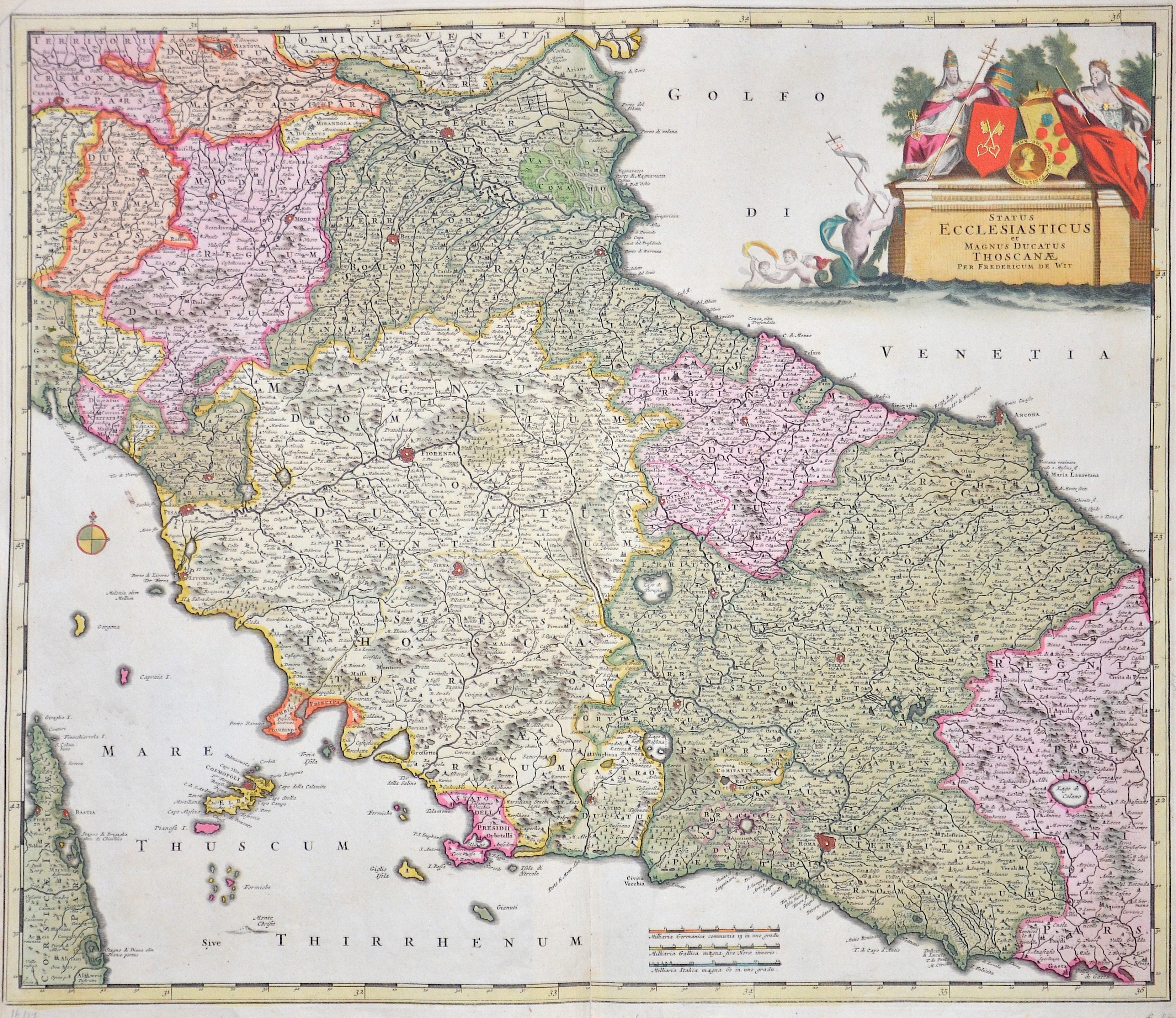
Satus Ecclesiasticus et Magnus ducatus Thoscanae

| Article ID | EUI4373 |
Title | Satus Ecclesiasticus et Magnus ducatus Thoscanae |
Description | Map shows central Italy, the whole of Tuscany with the cities of Pisa, Livorno, Bologna, Florence, Ferrara, Ravenna, Urbino, Siena, Orvieto, Spoleto, Rome, etc., the island of Elba and a magnificent cartridge. |
| Year | ca. 1660 |
Artist | Wit, de (1610-1698) |
Frederik de Wit (1610 – 1698). His Atlas began to appear around 1662 and by 1671 included anywhere from 17 to 151 maps each. In the 1690s he began to use a new title page "Atlas Maior" but continued to use his old title page. His atlas of the Low Countries first published in 1667,was named Nieuw Kaertboeck van de XVII Nederlandse Provinciën and contained 14 to 25 maps. Frederik de Wit quickly expanded upon his first small folio atlas which contained mostly maps printed from plates that he had acquired, to an atlas with 27 maps engraved by or for him. By 1671 he was publishing a large folio atlas with as many as 100 maps. Smaller atlases of 17 or 27 or 51 maps could still be purchased and by the mid-1670s an atlas of as many as 151 maps and charts could be purchased from his shop. In ca.1675 Frederik de Wit released a new nautical atlas. The charts in this atlas replaced the earlier charts from 1664 that are known today in only four bound examples and a few loose copies. Frederik de Wit new charts were sold in a chart book and as part of his atlases. Frederik de Wit published no fewer than 158 land maps and 43 charts on separate folio sheets. In 1695 Frederik de Wit began to publish a town atlas of the Netherlands after he acquired a large number of city plans at the auction of the famous Blaeu publishing firm’s printing plates. Dating Frederik de Wit atlases is considered difficult because usually no dates were recorded on the maps and their dates of publication extended over many years. | |
Historical Description | Central Italy is the central section of the Italy peninsula, which is divided into northern Italy, central Italy and southern Italy. It stretches from the Apennine ridge between La Spezia and Rimini to the historic northern border of the Kingdom of Naples. The southern boundary today runs along the rivers Tronto and Garigliano after changes in the provinces in the 1920s. Central Italy is formed by the regions of Tuscany, Umbria, Marche and Lazio, whereby only Tuscany can be linguistically and culturally uniformly classified as Central Italy. Within these borders, central Italy also forms one of the five Italian macro regions. In ancient times, in northern Italy, unlike in southern Italy, there was hardly any Greek colonization. For the Roman Empire, Northern Italy was initially Gallia cisalpina. Since the Middle Ages, northern Italy has been characterized by remarkable trading cities, which, starting from the Veronese Confederation, united in the Lombardenbund against Emperor Barbarossa. The history of Italy, documented by written sources, begins only after the settlement by Italian peoples. Alongside them, the culture of the Etruscans, whose origin is unknown, was experienced around 600 BC. Their heyday. In the 8th century BC The Greek colonization of the southern Italian mainland and Sicily had begun, and Phoenicians settled on the west coast of the island. These colonies later belonged to Carthage. From the 4th century BC began the expansion of Rome. From the 5th century Italy came under the rule of Germanic tribes, the population declined drastically until around 650, and Ostrom briefly conquered the former core area of the empire in the 6th century. In the 8th century, the north, ruled by the Lombards for about two centuries, was annexed to the Franconian Empire, later to the Holy Roman Empire, while Arabs and Byzantines ruled in the south from the 11th century onwards. In most regions, feudalism prevailed in the early Middle Ages. The northern Italian municipalities, which came together in the Lombardenbund, were able to free themselves from the influence of the empire in the 12th and 13th centuries and establish their own territories. Of this multitude of territories, the most important were Milan, the sea powers Genoa and Venice, Florence and Rome, and the south of Italy, which was partly French and partly Spanish. After four centuries of fragmentation and foreign rule, the peninsula became politically united in the course of the Risorgimento national movement. The modern Italian state was founded in 1861. |
| Place of Publication | Amsterdam |
| Dimensions (cm) | 49 x 57,5 cm |
| Condition | Some restoration at lower centerfold |
| Coloring | original colored |
| Technique | Copper print |