

Adina Sommer
Antique and Contemporary Art
Winzerer Str. 154
80797 München
telephone
+49 89 304714
business hours:
by appointment
Email
![]()


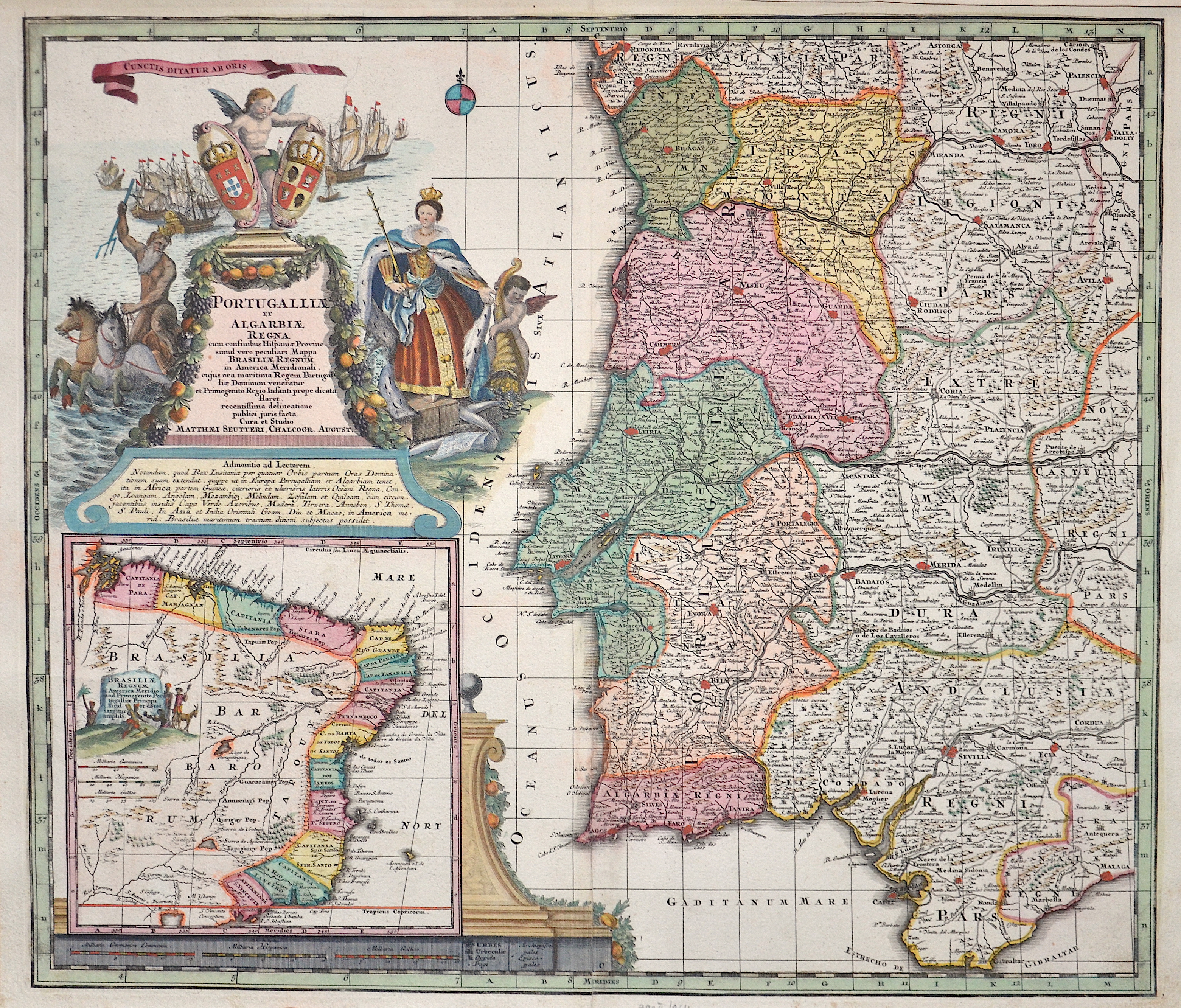
Portuglaiae et Algarbiae regna …

| Article ID | EUE772 |
Title | Portuglaiae et Algarbiae regna … |
Description | Map shows Portugal wit an insert map of Barsilia as colony. |
| Year | ca. 1730 |
Artist | Seutter (1678-1757) |
Matthias Seutter (1678- 1757) Augsburg was the son of a goldsmith in Augsburg. In 1697, Seutter began his studies in Nuremberg and subsequently worked in the publishing house of Jeremias Wolff in Augsburg. In 1710, he established his own publishing house and print shop. The Seutter publishing house produced a great number of maps, atlases, and globes. However, very few original maps were printed there, as Augsburg at that time had no university and no connection to the fields of mathematics or the natural sciences. Seutter therefore copied the work of other cartographers, making his own engravings based on their models. Over 500 maps were produced in his studio. Seutter's most well-known works are the 1725 "Geographical Atlas or an Accurate Depiction of the Whole World" ("Atlas Geographicus oder Accurate Vorstellung der ganzen Welt") with 46 maps, the 1734 "Large Atlas" ("Grosser Atlas") with 131 maps, and the 1744 pocket atlas "Small Atlas" ("Atlas minor") with 64 maps. Matthäus Seutter died in 1757. Seutter's son Albrecht Karl, his son-in-law Conrad Tobias Lotter, and his business partner Johann Michael Probst ran the printing business for five more years. | |
Historical Description | Portugal is the oldest state on the Iberian Peninsula and one of the oldest in Europe, its territory having been continuously settled, invaded and fought over since prehistoric times. The pre-Celtic people, Celts, Carthaginians and Romans were followed by the invasions of the Visigoths and Suebi Germanic peoples. In the 15th and 16th centuries, Portugal established the first global empire, becoming one of the world's major economic, political and military powers. During this period, today referred to as the Age of Discovery, Portuguese explorers pioneered maritime exploration, notably under royal patronage of Prince Henry the Navigator and King John II, with such notable voyages as Bartolomeu Dias' sailing beyond the Cape of Good Hope (1488), Vasco da Gama's discovery of the sea route to India (1497–98) and the European discovery of Brazil (1500). During this time Portugal monopolized the spice trade, divided the world into hemispheres of dominion with Castille, and the empire expanded with military campaigns in Asia. However, events such as the 1755 Lisbon earthquake, the country's occupation during the Napoleonic Wars, the independence of Brazil (1822), and a late industrialization compared to other European powers, erased to a great extent Portugal's prior opulence. |
| Place of Publication | Augsburg |
| Dimensions (cm) | 49 x 56 |
| Condition | Very good |
| Coloring | original colored |
| Technique | Copper print |