

Adina Sommer
Antique and Contemporary Art
Winzerer Str. 154
80797 München
telephone
+49 89 304714
business hours:
by appointment
Email
![]()


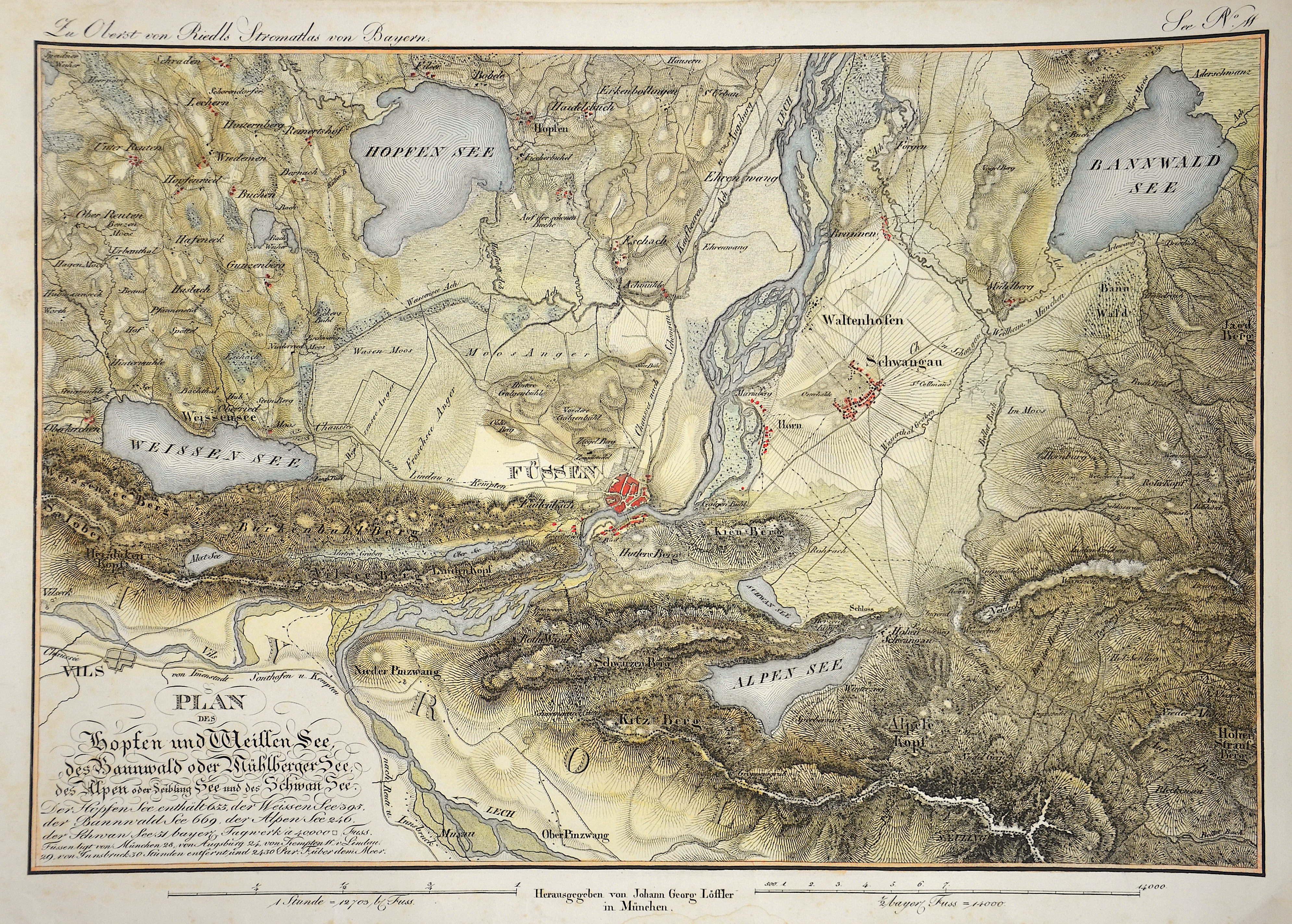
Plan des Hopfen und Weissen See, des Bannwald oder Mühlberger See, des Alpen oder Seibling See und des Schwan See.

| Article ID | EUD4505 |
Title | Plan des Hopfen und Weissen See, des Bannwald oder Mühlberger See, des Alpen oder Seibling See und des Schwan See. |
Description | DEcorative and detailed map of area of the city Füssen inthe eastern Allgau with the lakes Hopfen-, Weiße-n, Alpen- and Bannwald-. Issued by J. G. Löffler after Riedl. |
| Year | ca. 1830 |
Artist | Riedl (1746-1809) |
Adrian Franz Xaver Florian Riedl, from 1790 von Riedl (1746-1809) was a German topographer and cartographer, coming from a family of cartographers who determined construction and surveying in Bavaria for over 75 years. In 1764 he fell on the scholars of the Bavarian Academy of Sciences in Munich through his cartographic implementation of the survey results of the French cartographer César François Cassini de Thury (1714–1784), which he had carried out in 1761 and 1762 in Bavaria. After the examination by the academy, Riedl was appointed electoral land geometer in 1766 and commissioned with the recording of the Bavarian road network in 1769. Over the years he followed his father in his positions as court chamber councilor (1771) and water, bridge and road construction commissioner ( 1772) according to. Together with General Building Director Joseph Aloys von Hofstetten, he developed the institutionalization and professionalization of construction and surveying. Adrian von Riedl's cartographic work of the Bavarian colonel and in various offices with road, bridge and especially hydraulic engineering could have been crowned with the Stromatlas if it had not been unfinished due to his sudden death. Nevertheless, the sheets published in several subscription deliveries were and still are the best and most accurate reproduction of Bavarian waters and could only be replaced by the Topographical Bureau 1812-1867 (see Topographical Atlas of Baiern) in the course of the official state survey. | |
Historical Description | Swabia also Suabia or Svebia, is a cultural, historic and linguistic region in southwestern Germany. The name is ultimately derived from the medieval Duchy of Swabia, one of the German stem duchies, representing the territory of Alemannia, whose inhabitants interchangeably were called Alemanni or Suebi. A new Swabian League (Schwäbischer Bund) was formed in 1488, opposing the expansionist Bavarian dukes from the House of Wittelsbach and the revolutionary threat from the south in the form of the Swiss. The territory of Swabia as understood today emerges in the early modern period. It corresponds to the Swabian Circle established in 1512. The Old Swiss Confederacy was de facto independent from Swabia from 1499 as a result of the Swabian War, while the Margraviate of Baden had been detached from Swabia since the twelfth century. Fearing the power of the greater princes, the cities and smaller secular rulers of Swabia joined to form the Swabian League in the fifteenth century. The League was quite successful, notably expelling the Duke of Württemberg in 1519 and putting in his place a Habsburg governor, but the league broke up a few years later over religious differences inspired by the Reformation, and the Duke of Württemberg was soon restored. The region was quite divided by the Reformation. While secular princes such as the Duke of Württemberg and the Margrave of Baden-Durlach, as well as most of the Free Cities, became Protestant, the ecclesiastical territories (including the bishoprics of Augsburg, Konstanz and the numerous Imperial abbeys) remained Catholic, as did the territories belonging to the Habsburgs (Further Austria), the Sigmaringen branch of the House of Hohenzollern, and the Margrave of Baden-Baden. |
| Place of Publication | Munich |
| Dimensions (cm) | 34 x 46,5 cm |
| Condition | Little stains |
| Coloring | original colored |
| Technique | Copper print |