

Adina Sommer
Antique and Contemporary Art
Winzerer Str. 154
80797 München
telephone
+49 89 304714
business hours:
by appointment
Email
![]()


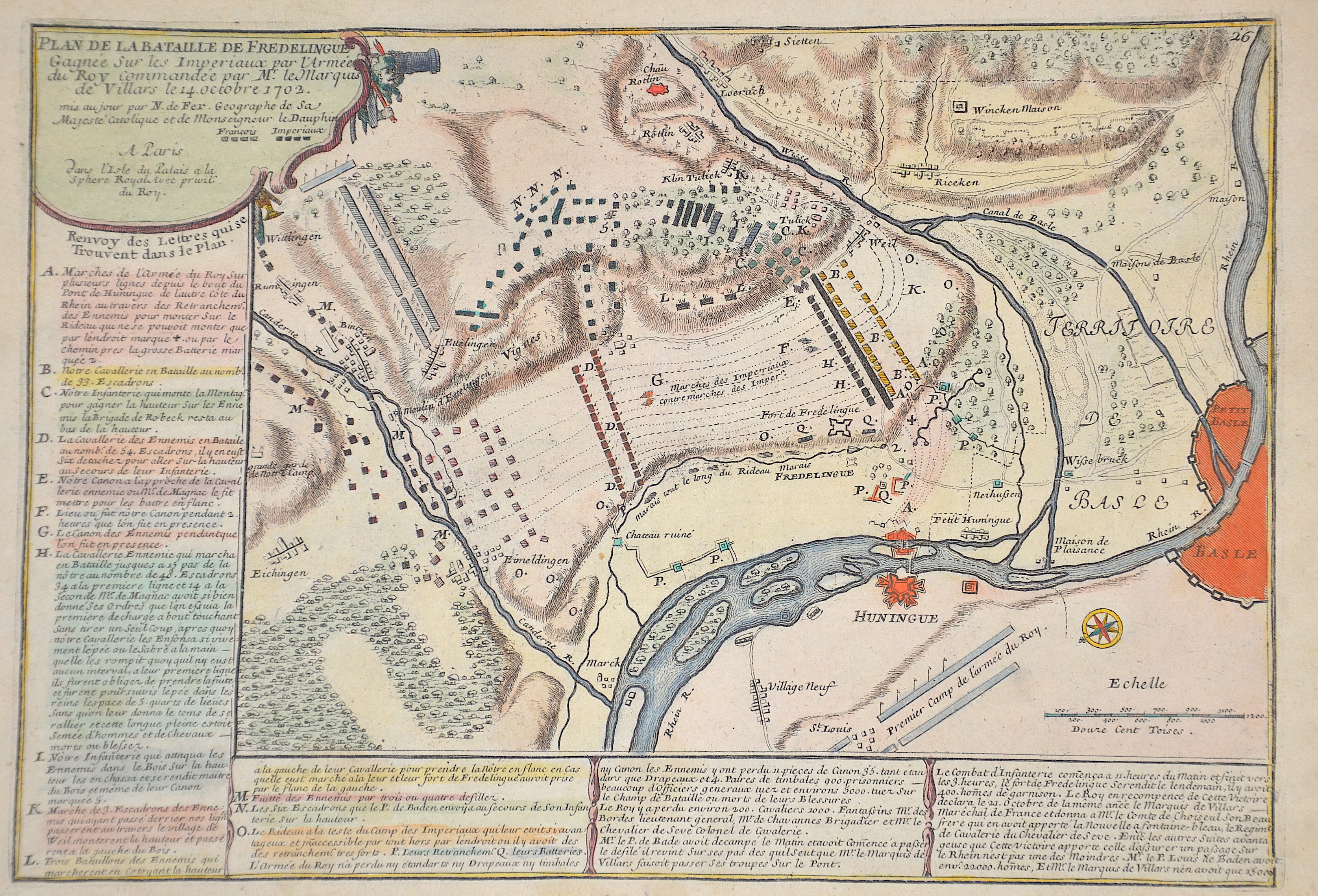
Plan de la Bataille de Fredelingue Gagnée Sur les Imperiaux par l’Armée du Roy commandeé par Mr. Le Marquis de Villars le 14. Octobre 1702.

| Article ID | EUD5075 |
Title | Plan de la Bataille de Fredelingue Gagnée Sur les Imperiaux par l’Armée du Roy commandeé par Mr. Le Marquis de Villars le 14. Octobre 1702. |
Description | Plan of the Battle of Fredelingue Gagnée Sur les Imperiaux par l'Armée du Roy commandé par Mr. Le Marquis de Villars le 14. octobre 1702. Copper engraving shows the surroundings of Weil am Rhein between Lörrach, Grenach, Basel, Hüningen with troop positions and a description of the battle at the left and lower margin. The Battle of Friedlingen was a battle of the War of the Spanish Succession. It took place on October 14, 1702 in the border triangle at the gates of Basel and about 60 km south of Freiburg im Breisgau. The battlefield covered Friedlingen, Weil, Haltingen (today all districts of Weil am Rhein) and Tüllingen (today a district of Lörrach). At the end of the battle there was no clear winner. However, a unification of the French troops with the Bavarians was prevented for the first year of the war. |
| Year | ca. 1705 |
Artist | Fer, de (1646-1720) |
Nicolas de Fer ( 1646 - 1720 in Paris) was a French cartographer and geographer. He also was an engraver and publisher. De Fer was the youngest of three sons of Antoine de Fer, who was also a cartographer. When he was 12, he became the apprentice of Parisian engraver Louis Spirinx, and made his first map, of the Canal du Midi, at the age of 23. After the death of his father in June 1673, de Fer was so successful at improving the firm that, in 1690, he became the official geographer to Louis, Dauphin of France. With support from the Spanish and French Royal Families, de Fer also became official geographer for Philip V and Louis XIV, the kings of Spain and France, respectively. Because of this, his maps became Bourbon propaganda, endorsing French King Louis XIV. His business flourished, producing town plans, atlases, wall maps, and more than 600 sheet maps.He made maps of places in Europe and North America, including New Spain, places fortified by Vauban, the Low Countries, and the War of the Spanish Succession. In 1698, de Fer published a map of North America, which included a depiction of beavers building dams near Niagara Falls. Seventeen years later, Herman Moll published an identical map as his own, known as the -Beaver map-. De Fer became the official geographer for His Catholic Majesty in 1720.Two of his sons-in-law, Guillaume Danet and Jaques-François Bénard, continued the company after de Fer's death on 25 October of that year until around 1760. | |
Historical Description | The present village of Weil was first mentioned in a document in 786 under the name of Willa. A certain Ercanpert donated his share of the church in Willa (Weil) to the monastery of St. Gallen. The monasteries of St. Blasien and Weitenau also had possessions in the village. The cathedral chapter of Basel also owned land here and the cathedral courtyard, which served to collect church taxes and, with its new building of 1569, was the economic center and place of jurisdiction for Weil. For a long time Weil was characterized by agriculture and especially by viticulture. Due to the favorable traffic situation Weil developed into a town since the middle of the 19th century. |
| Place of Publication | Paris |
| Dimensions (cm) | 23,5 x 34 cm |
| Condition | Perfect condition |
| Coloring | original colored |
| Technique | Copper print |