

Adina Sommer
Antique and Contemporary Art
Winzerer Str. 154
80797 München
telephone
+49 89 304714
business hours:
by appointment
Email
![]()


Opmerkelyke Reystogten van den Heer Antony Sherley gedann in den Jare 1599 na Persien…..

| Article ID | B0072 |
Title | Opmerkelyke Reystogten van den Heer Antony Sherley gedann in den Jare 1599 na Persien….. |
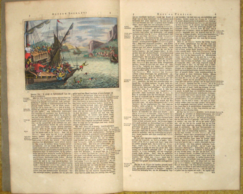
Description | Book describes the travel of Antony Sherley to Persia in the year of 1599 on 24 pages with a content index. Content: 1 title page an 2 views of Turkey and Cyprus. |
| Year | dated 1706 |
Artist | Aa, van der (1659-1733) |
Pieter van der Aa ( 1659 - 1733) was a Dutch publisher best known for preparing maps and atlases, though he also printed pirated editions of foreign bestsellers and illustrated volumes. He also printed many maps that were often out of print, which he reissued. Some of his most popular maps were of the African continent, detailing locations such as Morocco and Madagascar. Many of his later works were printed for the general public in French and Dutch. Pieter van der Aa began his career at Leiden in 1683 as a Latin trade publisher, publishing classical texts pertaining to medicine and science. As he progressed, he began to publish atlases and maps, compiling numerous multi-volume collections of works. His ambition to become Leiden's most famous printer was fulfilled in 1715 with his appointment to head printer for the city and its university. One of Pieter van der Aa's largest compilations relates to the history of Italy and Sicily, an area of immense personal interest. Though he took credit for many of his compilations, several, such as the Dutch collection of travels to the East and West Indies, were admittedly simple improvements to others' works. | |
Historical Description | Asia is Earth's largest and most populous continent, located primarily in the Eastern and Northern Hemispheres. The history of Asia can be seen as the distinct histories of several peripheral coastal regions: East Asia, South Asia, Southeast Asia and the Middle East, linked by the interior mass of the Central Asian steppes. The coastal periphery was home to some of the world's earliest known civilizations, each of them developing around fertile river valleys. The civilizations in Mesopotamia, the Indus Valley and the Yellow River shared many similarities. These civilizations may well have exchanged technologies and ideas such as mathematics and the wheel. Other innovations, such as writing, seem to have been developed individually in each area. Cities, states and empires developed in these lowlands. The central steppe region had long been inhabited by horse-mounted nomads who could reach all areas of Asia from the steppes. The earliest postulated expansion out of the steppe is that of the Indo-Europeans, who spread their languages into the Middle East, South Asia, and the borders of China, where the Tocharians resided. The northernmost part of Asia, including much of Siberia, was largely inaccessible to the steppe nomads, owing to the dense forests, climate and tundra. These areas remained very sparsely populated. The center and the peripheries were mostly kept separated by mountains and deserts. The Caucasus and Himalaya mountains and the Karakum and Gobi deserts formed barriers that the steppe horsemen could cross only with difficulty. While the urban city dwellers were more advanced technologically and socially, in many cases they could do little in a military aspect to defend against the mounted hordes of the steppe. However, the lowlands did not have enough open grasslands to support a large horsebound force; for this and other reasons, the nomads who conquered states in China, India, and the Middle East often found themselves adapting to the local, more affluent societies. |
| Place of Publication | Leiden |
| Dimensions (cm) | 35,5 x 44 |
| Condition | Very good |
| Coloring | original colored |
| Technique | Copper print |