

Adina Sommer
Antique and Contemporary Art
Winzerer Str. 154
80797 München
telephone
+49 89 304714
business hours:
by appointment
Email
![]()


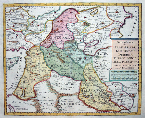
Nuova Carta di Irak Arabi, Kurdistan Diarbek Tucrcomannia, Siria, e Palestina …

| Article ID | AST0618 |
Title | Nuova Carta di Irak Arabi, Kurdistan Diarbek Tucrcomannia, Siria, e Palestina … |
Description | Map shows the eastern part of Turkey with Syria, Libanon, Irak, Jordan and partly Arabia. |
| Year | ca. 1735 |
Artist | Tirion (1705-1765) |
Isaak Tirion (1705 1765) was a Dutch bookseller and publisher. He is known for his Hedendaagsche historie (Modern History) and his Vaderlandse Historie, both historical reference works illustrated with engravings by leading Amsterdam artists. Of particular interest today are his map works, such as the United Netherlands in twelve parts and "Tegenwoordige Staat van alle Volken" ("Present State of All Nations") in 45 parts. Some of his atlases were published after his death, such as the Atlas van Zeeland in 1760, which was published again and again until 1784. | |
Historical Description | Western Asia, is the westernmost subregion of Asia with the following countries: Egypt (Peninsula Sinai only), Bahrain, Iran, Iraq, Israel, Jordan, Kuwait, Lebanon, Oman, Qatar, Palestinian territories (called West Bank and Gaza in the latter), Saudi Arabia, Syria, Turkey, UAE, Turkey, Georgia, Cyprus and Yemen.The concept is in limited use, as it significantly overlaps with the Middle East (or the Near East), the main difference usually being the exclusion of the majority of Egypt (which would be counted as part of North Africa) and the inclusion of the Caucasus. As a geographic concept, Western Asia includes the Levant, Mesopotamia, Anatolia, Iran, the Armenian Highlands, the South Caucasus, the Arabian peninsula as well as the Sinai Peninsula, making Egypt a transcontinental country. |
| Place of Publication | Amsterdam |
| Dimensions (cm) | 27 x 33 |
| Condition | Very good |
| Coloring | original colored |
| Technique | Copper print |