

Adina Sommer
Antique and Contemporary Art
Winzerer Str. 154
80797 München
telephone
+49 89 304714
business hours:
by appointment
Email
![]()


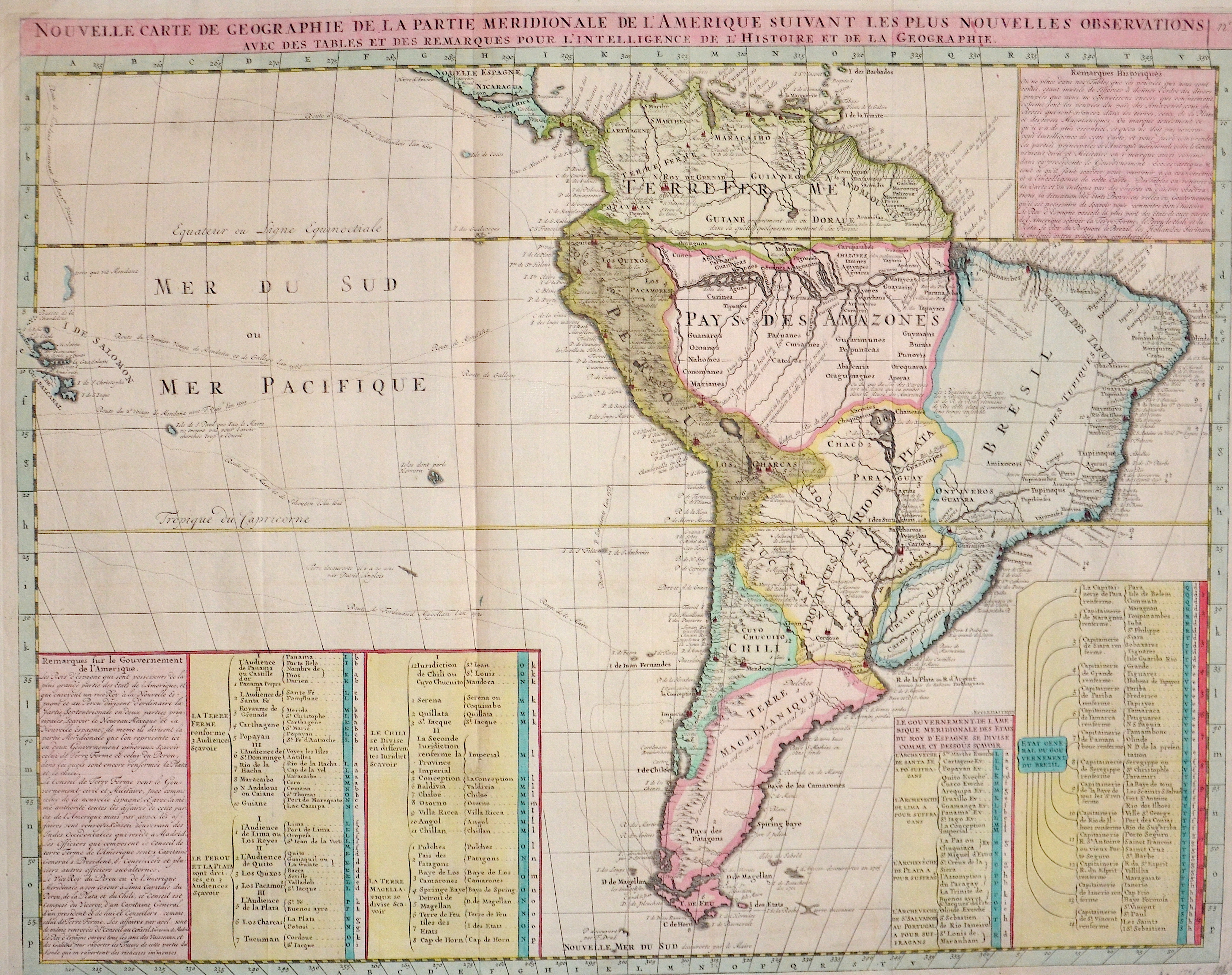
Nouvelle Carte de Geographie de la Partie Meridionale de l’Amerique suivant les plus nouvelles observations..

| Article ID | AMS1235 |
Title | Nouvelle Carte de Geographie de la Partie Meridionale de l’Amerique suivant les plus nouvelles observations.. |
Description | A Map of South America and a index. One of the earliest known South American civilizations was at Norte Chico, on the central Peruvian coast. Though a pre-ceramic culture, the monumental architecture of Norte Chico is contemporaneous with the pyramids of Ancient Egypt. |
| Year | ca. 1710 |
Artist | Chatelain (1684-1743) |
Henri Abraham Chatelain (1684 - 1743) was a Huguenot pastor of Parisian origins. He lived consecutively in Paris, St. Martins, London (c. 1710), The Hague (c. 1721) and Amsterdam (c. 1728). He is best known as a Dutch cartographer and more specifically for his cartographic contribution in the seminal seven volume Atlas Historique, published in Amsterdam between 1705 and 1720. Innovative for its time, the Atlas Historique combined fine engraving and artwork with scholarly studies of geography, history, ethnology, heraldry, and cosmography. Some scholarship suggests that the Atlas Historique was not exclusively compiled by Henri Chatelain, as is commonly believed, but rather was a family enterprise involving Henri, his father Zacharie and his brother, also Zacharie. | |
Historical Description | One of the earliest known South American civilizations was at Norte Chico, on the central Peruvian coast. Though a pre-ceramic culture, the monumental architecture of Norte Chico is contemporaneous with the pyramids of Ancient Egypt. In 1494, Portugal and Spain, the two great maritime European powers of that time, on the expectation of new lands being discovered in the west, signed the Treaty of Tordesillas, by which they agreed, with the support of the Pope, that all the land outside Europe should be an exclusive duopoly between the two countries. Beginning in the 1530s, the people and natural resources of South America were repeatedly exploited by foreign conquistadors, first from Spain and later from Portugal. These competing colonial nations claimed the land and resources as their own and divided it in colonies. The Spaniards were committed to convert their native subjects to Christianity and were quick to purge any native cultural practices that hindered this end; however, many initial attempts at this were only partially successful, as native groups simply blended Catholicism with their established beliefs and practices. Furthermore, the Spaniards brought their language to the degree they did with their religion, although the Roman Catholic Church's evangelization in Quechua, Aymara, and Guaraní actually contributed to the continuous use of these native languages albeit only in the oral form. Guyana was first a Dutch, and then a British colony, though there was a brief period during the Napoleonic Wars when it was colonized by the French. The country was once partitioned into three parts, each being controlled by one of the colonial powers until the country was finally taken over fully by the British. The first South American country to abolish slavery was Chile in 1823, Uruguay in 1830, Bolivia in 1831, Colombia and Ecuador in 1851, Argentina in 1853, Peru and Venezuela in 1854, Paraguay in 1869, and in 1888 Brazil was the last South American nation and the last country in western world to abolish slavery. |
| Place of Publication | Paris |
| Dimensions (cm) | 47 x 59,5 cm |
| Condition | Perfect condition |
| Coloring | original colored |
| Technique | Copper print |