

Adina Sommer
Antique and Contemporary Art
Winzerer Str. 154
80797 München
telephone
+49 89 304714
business hours:
by appointment
Email
![]()


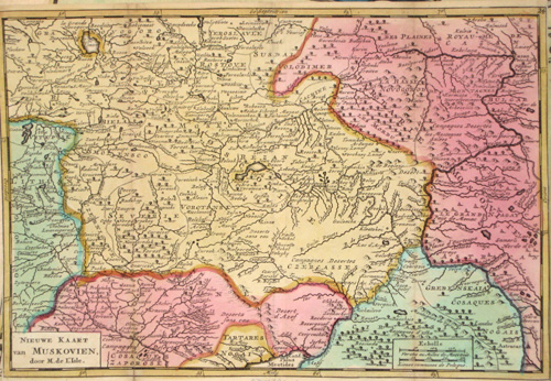
Nieuwe Kaart van Muskovien ….

| Article ID | EUO2258 |
Title | Nieuwe Kaart van Muskovien …. |
Description | map shows the area around Moscow |
| Year | ca. 1720 |
Artist | L´Isle, de /Covens & Mortier (1675-1726) |
Guillaume De L’Isle (1675–1726) was a renowned French cartographer famous for his accurate maps of Europe, the Americas, and Africa. He joined the French Académie Royale des Sciences, signing his maps as “Géographe de l’Académie,” and later became Premier Géographe du Roi in 1718, teaching geography to the Dauphin. De L’Isle mostly worked from his office, relying on a strong network of traveler reports and scientific updates, ensuring his maps were precise and honest. He openly noted uncertain information, such as a disputed river in Louisiana. In 1700, he won a legal case against Jean-Baptiste Nolin for plagiarism. Unlike the Sanson workshop, which often published outdated maps, De L’Isle focused on up-to-date, scientifically grounded cartography. | |
Historical Description | The region lies in the fertile basin of the Volga, Oka, Kljasma and Moskva rivers. In the north and west of the oblast lies the Moscow Ridge, which reaches up to 310 m in height with the Klin-Dmitrov Ridge. To the east and southeast is the Meshchora lowland. In the southwest lies the Central Russian Plate. In the middle of the 12th century, the territory of today's Moscow Oblast was annexed to the Principality of Vladimir-Suzdal. At the same time, cities such as Volokolamsk, Moscow, Svenigorod, Dmitrov were founded. From 1708, the area belonged to the Moscow governorate founded by Peter I. From the 18th to the 19th century, light industry, especially the textile industry, experienced a boom. Its important centres were Bogorodsk, Pavlovsky Possad and Orechovo-Suyevo. In 1851, the first railway line was laid on the territory of the Moscow governorate, connecting Moscow with St. Petersburg. Several times, new oblasts were formed from parts of the Moscow Oblast: Kalinin Oblast in 1935, Ryazan Oblast and Tula Oblast in 1937, Kaluga Oblast in 1944 and Vladimir Oblast in 1944. |
| Place of Publication | Paris |
| Dimensions (cm) | 17,5 x 26 |
| Condition | Very good |
| Coloring | original colored |
| Technique | Copper print |