

Adina Sommer
Antique and Contemporary Art
Winzerer Str. 154
80797 München
telephone
+49 89 304714
business hours:
by appointment
Email
![]()


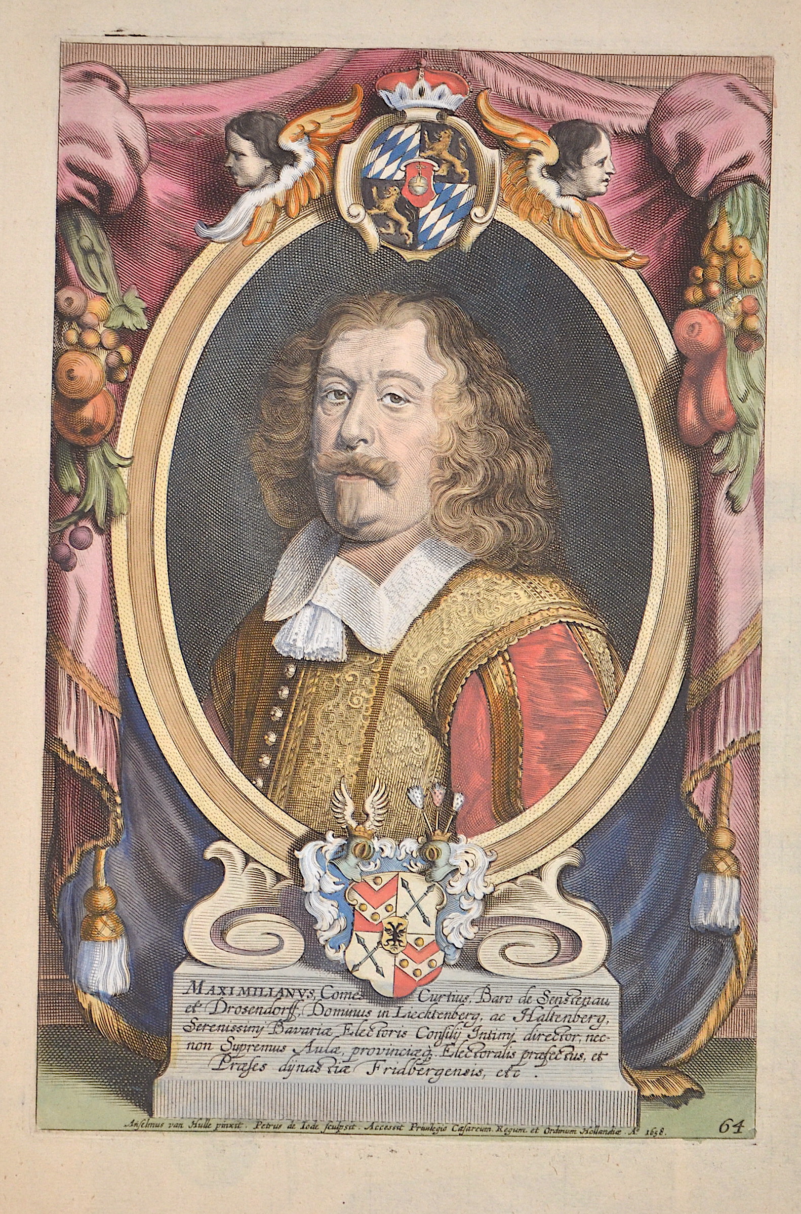
Maximilianus, Comes Curtius, Baro de Senstenau, et Drosendorff, Dominus in Liecktenberg, ac Haltenberg, Serenissimi Bavariae Electoris Confilii…

| Article ID | T0116 |
Title | Maximilianus, Comes Curtius, Baro de Senstenau, et Drosendorff, Dominus in Liecktenberg, ac Haltenberg, Serenissimi Bavariae Electoris Confilii… |
Description | Decorative title page of Maximilian Graf von Valley (1595 - 1662). He comes from the royal house of Arco and was grown up in Munich. The director of the Privy Council was envoy to the Peace of Westphalia in 1648, Hofmarksherr vonhaltenberg and Lichtenberg, Count von Valley in Ahamstein, Holzolling and Feldolling, caretaker in Bärnstein, Kling and Friedberg. Copper engraving by P. de Jode after A. van Hulle. As a descendant of the Arco (aristocratic family), Arco-Valley attended the Wilhelmsgymnasium in Munich until graduation in 1823. He studied at the University of Strasbourg and the University of Landshut, which was moved to Munich in 1826. In the same year he became active in the Corps Isaria Munich. He was the owner of the dominions of St. Martin and Aurolzmünster in Austria and the Bavarian estates Valley, Adldorf, Malgersdorf, Oberköllnbach and Baumgarten. Maximilian von und zu Arco-Valley was also a co-founder of the Süddeutsche Bodenkreditbank. In 1828 he became a member of the Chamber of the Bavarian Imperial Councils for life. From 1868 to 1870 he was also a member of the customs parliament as a member of the Schwaben 3 constituency (Dillingen, Günzburg, Zusmarshausen). There he represented the political direction of the Bavarian Patriot Party. |
| Year | dated 1658 |
Artist | Jode,de (1509-1591) |
Gerard de Jode (1509–1591)Antwerp, was a cartographer, engraver and. In 1547 he was admitted to the Guild of St. Luke, and began his work as a publisher and printseller. He often printed the works of other cartographers including Gastaldi's map of the world in 1555, Jacob van Deventer's map of Brabant in 1558, Ortelius' eight sheet map of the world in 1564, and maps by Bartholomeus Musinus and Fernando Alvares Seco. His most outstanding work is a two volume atlas Speculum Orbis Terrarum published in 1578. It was aimed at competing with another atlas, Theatrum Orbis Terrarum by Ortelius, published eight years earlier in 1570. The competing atlas had become so popular by the time he finally published his own atlas however, that his version never sold well, despite his outstanding reputation. Only about a dozen examples have survived. Gerard de Jode made plans for another enlarged edition, which was uncompleted at his death in 1591. His son Cornelis de Jode took over and published the Speculum Orbis Terrae in 1593. This never sold well either. Scholars consider many of de Jode's maps to be superior to those of Ortelius, both in detail and style. In constructing his world map, HEMISPHERIUM AB AEQUINOCTIALI LINEA, AD CIRCULUM POLI ANTARCTICI, published in 1593, Gerard de Jode was strongly influenced by Guillaume Postel’s 1581 polar planisphère, Polo aptata Nova Charta Universi. Gerard de Jode was probably the maker of a globe made in Antwerp that also owes much to the cosmographic ideas of Guillaume Postel. | |
Historical Description | The title page is one of the most important parts of an atlas or book. It appears at the beginning of the book and describes the actual title and the context or subject of the book or atlas. The title page often shows the title of the work, the person or institution responsible for its intellectual content, and the imprint, which includes the name and address of the publisher as well as the date of publication. Further information about the publication is often printed on the back of the title page.The first printed books or incunabula had no title pages: the text simply began on the first page, and the book was often identified by its opening words – the incipit. Maps were usually published in atlases, and atlases were books with titles. Even here, title pages were individual works of art. A publisher emphasized the importance of a book by introducing it with a spectacular entrée.Usually, the images on an atlas title page referred to the subject matter: measuring instruments, mythological, astronomical, religious, scientific, and allegorical references and facts were combined in a composition that represented the pride of scientific and intellectual progress. An atlas title page is often no more than an outstanding artistic and expressive cartouche. |
| Place of Publication | Antwerp |
| Dimensions (cm) | 31 x 20,5 |
| Condition | Small missing part at upper margin replaced |
| Coloring | colored |
| Technique | Copper print |