

- Alsace
- Aquitaine
- Auvergne
- Bourgogne
- Bourgogne-Franche-Comte
- Brittany
- Centre
- Champagne
- France Islands
- Gascogne
- Gironde
- Hauts-de-France
- Ile de France
- Languedoc
- Lothringen
- Midi-Pyrénées
- Nivernais
- Nord-Pas-de-Calais
- Normandie
- Occitanie
- Pas-de-Calais
- Pays de la Loire
- Picardie
- Poitou-Charentes
- Provence-Alpes-Cote d Azur
- Pyrénées
- Rhone- Alpes
- Saintonge
- Savoyen
- Tourain
- Westcoast
Adina Sommer
Antique and Contemporary Art
Winzerer Str. 154
80797 München
telephone
+49 89 304714
business hours:
by appointment
Email
![]()


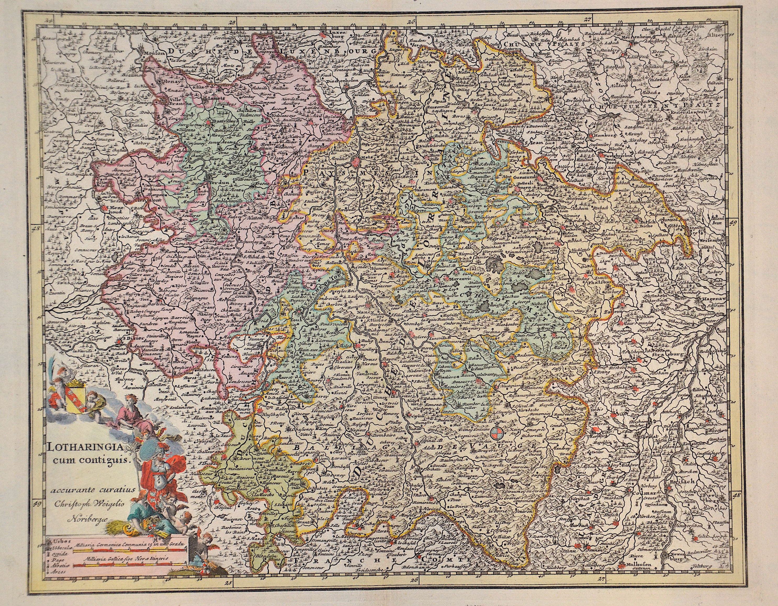
Lotharingia cum contiguis.

| Article ID | EUF4834 |
Title | Lotharingia cum contiguis. |
Description | Map shows the region of Lorraine with the city of Metz, a title cartouche and the coat of arms of the region Département Lorraine. |
| Year | ca. 1700 |
Artist | Weigel (1654-1725) |
Christoph Weigel the Elder (1654-1725) was a German engraver, art dealer and publisher. Christoph Weigel learned the art of copperplate engraving in Augsburg. After various positions, including in Vienna and Frankfurt am Main, he acquired citizenship in Nuremberg in 1698. The first Weigel work from his own, successfully run publishing house in Nuremberg was Die Bilderlust from 1698. This publishing house published around 70 books and engravings during his lifetime. One of his most important works is the status book from 1698. In it, Weigel described and described more than two hundred types of handicrafts and services, each illustrated by a copper engraving, based on life. Because Weigel visited almost all the workshops himself, drew and observed on site, agreed the content of his articles with the master craftsmen and signed important equipment from the original. Weigel worked particularly brilliantly in the scraping and line manner. He was the first engraver to use a kind of machine for the underground. In Nuremberg he worked very closely with the imperial geographer and cartographer Johann Baptist Homann (1664–1724) to create his maps. His younger brother Johann Christoph Weigel ran an art dealership in Nuremberg around the same time and was also very successful. | |
Historical Description | The area around the Moselle, populated mainly by Celtic tribes, was conquered by Gaius Iulius Caesar in the Gallic War between 58 and 51 BC and later became part of the Roman province of Gallia Belgica. From a division of the Frankish Empire into three parts, the Lotharii Regnum, the "Empire of Lothar" or Lotharingia, named after its king, emerged in 843. s lay in the middle between the East and West Frankish Empires and originally stretched as an elongated territory from the Mediterranean to the North Sea. In 870, the area was again divided between the East and West Frankish Empires. |
| Place of Publication | Nuremberg |
| Dimensions (cm) | 27 x 33,5 cm |
| Condition | Perfect condition |
| Coloring | original colored |
| Technique | Copper print |