

Adina Sommer
Antique and Contemporary Art
Winzerer Str. 154
80797 München
telephone
+49 89 304714
business hours:
by appointment
Email
![]()


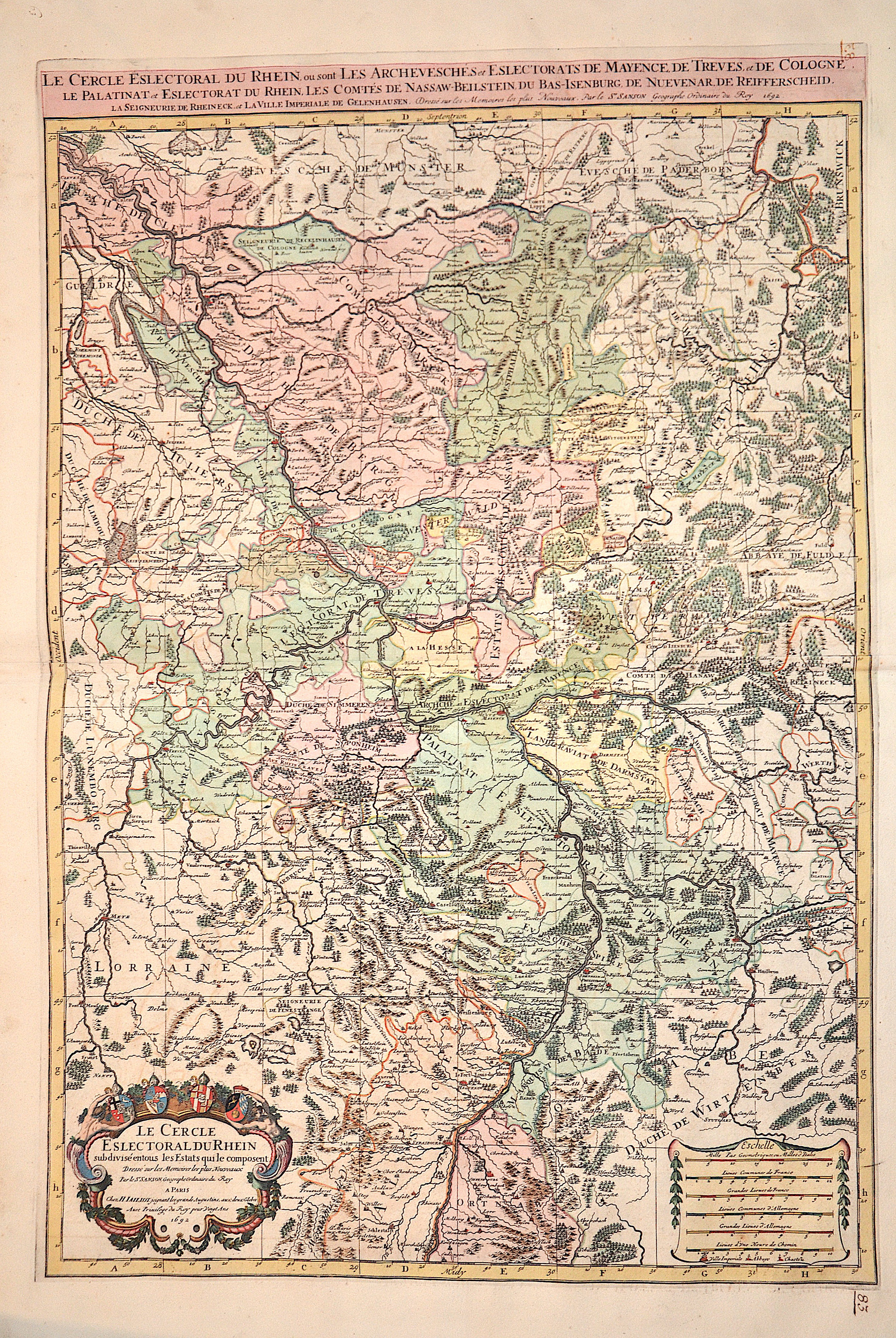
Le Cercle Eslectoral du Rhein sub divise entous les Estats qui le composent

| Article ID | EUD5307 |
Title | Le Cercle Eslectoral du Rhein sub divise entous les Estats qui le composent |
Description | Map shows the course of the Rhine from Strasbourg via Philippsburg, Mannheim, Worms, Mainz, Koblenz, Bonn, Cologne, Neuss, Düsburg to Kleve. It also shows the Rhine-Lahn district with the towns of Nassau, Dietz, Limburg an der Lahn, Runkel, Villmar, Wetzlar, Gießen, Marburg, etc. as well as the Main with Rüsselsheim, Frankfurt, Hanau, Aschaffenburg, Wertheim and the Moselle from Nancy via Pont-a-Mousson, Metz, Thionville, Trier, Zell, Cochem to Koblenz. Title cartouche with 4 coats of arms at lower left and a mileage scale cartouche at lower right. |
| Year | c. 1692 |
Artist | Jaillot (1632-1712) |
Alexis Hubert Jaillot (1632-1712) was an important French cartographer and publisher. In 1665 Jaillot married into the Berey family of map publishers. After the death of his brother-in-law Nicolas II Berey (1640–1667) he bought the Berey card collection from his sister-in-law. This gave him a valuable foundation that he could market straight away without ever having made a map himself. Jaillot entered the card business at an opportune moment. In early 1668, Louis XIV won the first of his Reunion Wars, and a period began when France was constantly expanding its territory. There was a great demand for maps depicting the French triumphs and the new frontiers, as well as upcoming expansion plans. Jaillot's map collection also included printing plates that Pierre Duval (1619–1683) (nephew of Nicolas Sanson) had created and originally sold to Nicolas Berey. But Duval, who also mislaid his cards himself, resisted the re-edition of his old cards. At the height of the dispute with Duval, Jaillot won Nicolas Sanson's sons Guillaume and Adrien in late 1670 as card makers and business partners. With them he was able to market new cards with the prestigious name Sansons. His first atlas of 1681, Atlas Nouveau, became such a great commercial success that other publishers began selling plagiarism. | |
Historical Description | The Rhine is one of the most important rivers in Europe and has played a significant role in the history and development of the region. It connects several countries, including Switzerland, Germany, France, and the Netherlands. In ancient Europe, the Rhine was an important border, separating the Roman Empire from the Germanic tribes to the north. The Romans used the Rhine as a trade and transport route and built several fortresses along the river to secure their border, including the well-known Limes (border fortifications). The Rhine played a central role in the spread of Roman culture and civilization in the areas along the river. In the Middle Ages, the Rhine was not only an important trade route but also a strategic political point. Cities like Cologne, Mainz, and Speyer along the Rhine developed into important commercial centers. The river was a central part of the Holy Roman Empire and played a key role in the political power dynamics of the region. In the late 18th and early 19th centuries, the Rhine underwent profound changes. During the French Revolution and the Napoleonic Wars, the Rhineland came under French control, and after Napoleon's downfall, it was controlled by Prussia and other German states, becoming an important part of the newly formed German Confederation. In the 19th century, the Rhine experienced significant economic transformation. With the expansion of the railway network and industrialization, the river became an important trade route for raw materials such as coal and iron. Cities like Düsseldorf, Leverkusen, and Mannheim experienced enormous growth and became industrial centers that directly benefited from access to the Rhine. Thus, the course of the Rhine has not only geographical significance but also a profound political, cultural, and economic impact that spans thousands of years. It has shaped both conflict and cooperation and remains a key resource for the countries through which it flows. |
| Place of Publication | Paris |
| Dimensions (cm) | 82,5 x 56 cm |
| Condition | Perfect condition |
| Coloring | original colored |
| Technique | Copper print |