

Adina Sommer
Antique and Contemporary Art
Winzerer Str. 154
80797 München
telephone
+49 89 304714
business hours:
by appointment
Email
![]()


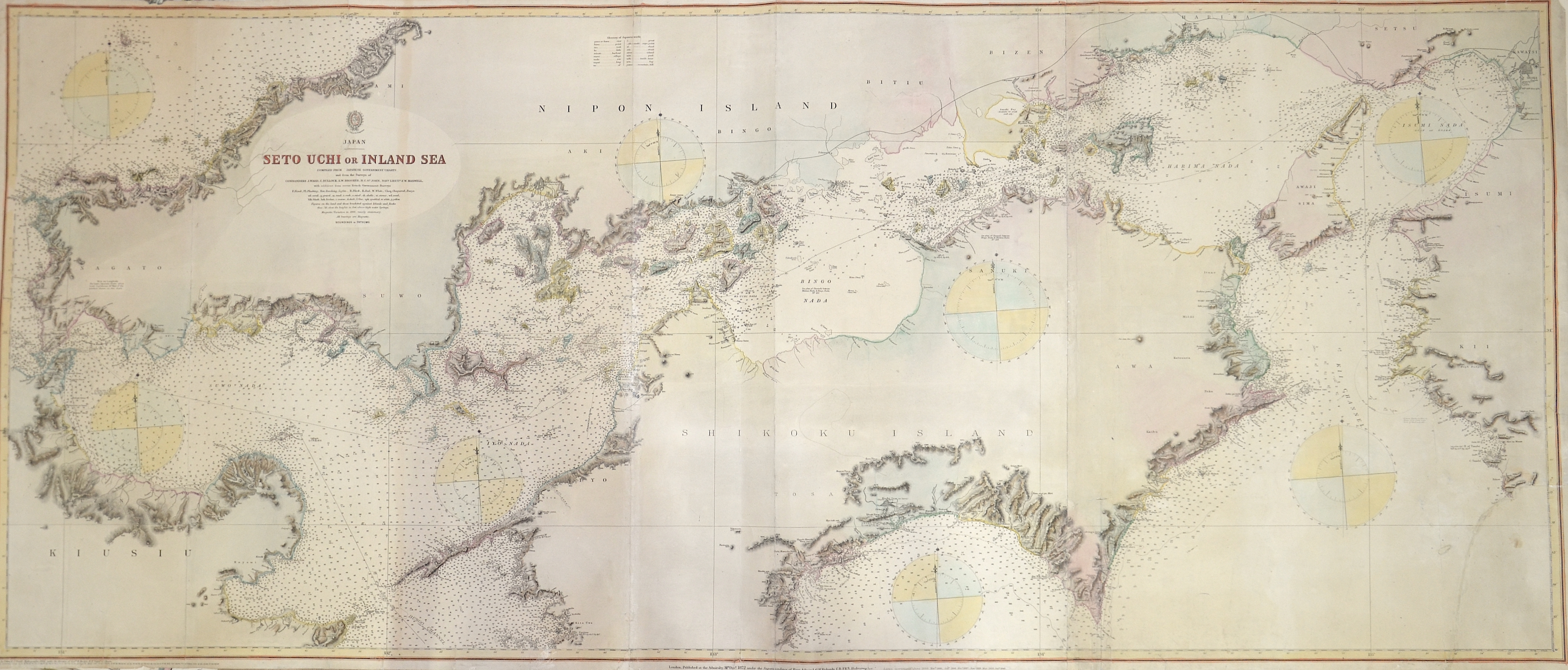
Japan Seto Uchi or Inland Sea

| Article ID | ASN1315 |
Title | Japan Seto Uchi or Inland Sea |
Description | Hydrographic map with drawn depths of the inland sea, Japanese Seto-Naikai in Japan. It is the body of water between the Japanese islands of Honshu, Shikoku and Kyushu. It consists of five different basins that are connected by channels. Its east-west length is about 440 km and its waters are easy to navigate. The sea has an irregular coastline and is dotted with hundreds of small islands, the largest of which is Awaji Island to the east. |
| Year | c. 1893 |
Artist | Powell |
Historical Description | In the 16th century, Portuguese traders and Jesuit missionaries first reached Japan and initiated direct commercial and cultural exchanges between Japan and the West. Oda Nobunaga used European technology and firearms to conquer many other daimyos. His power consolidation began in the so-called Azuchi Momoyama period. After Nobunaga's death in 1582, his successor Toyotomi Hideyoshi unified the nation in the early 1590s and launched two unsuccessful invasions of Korea in 1592 and 1597. He was appointed Shogun by Emperor Go-Yōzei in 1603 and founded the Tokugawa Shogunate in Edo (modern Tokyo). The shogunate enacted measures such as the Buk-Shohatto code of conduct to control the autonomous daimyōs and in 1639 the isolationist sakoku ("closed country") policy, which spanned two and a half centuries of weak political unity known as the Edo period (1603-1868) . During the isolation of Japan in the Edo period, entry and exit for Japanese and foreigners were prohibited. With the exception of limited exchanges with China and the Netherlands, who were the only Europeans allowed to stay in Japan on the artificial island of Dejima off Nagasaki in 1639, there was hardly any contact with other states. The Tokugawa family retained control of the other daimyo for over 250 years. This period was marked by great prosperity for the Japanese people. The population grew steadily. Today's Tokyo grew into the largest metropolitan area in the world during this time. The economic growth of modern Japan began during this period, leading to road and water transport routes, as well as financial instruments such as futures, banks, and insurance for the Osaka rice brokers. The study of western sciences (Rangaku) continued through contact with the Dutch enclave in Nagasaki. The Edo period led to Kokugaku ("National Studies"), the study of Japan by the Japanese. In 1854, Commodore Matthew Perry and the "Black Ships" of the United States Navy forced the opening of Japan to the outside world with the Kanagawa Convention. Later similar treaties with other Western countries brought economic and political crises with them. The cabinet took over Western political, judicial and military institutions, organized the privy council, introduced the Meiji constitution and assembled the Reichstag. |
| Place of Publication | London |
| Dimensions (cm) | 63,5 x 150 cm |
| Condition | Some folds partly restored, some minor tears restored, replaced lower right corner |
| Coloring | original colored |
| Technique | Steel engraving |