

Adina Sommer
Antique and Contemporary Art
Winzerer Str. 154
80797 München
telephone
+49 89 304714
business hours:
by appointment
Email
![]()


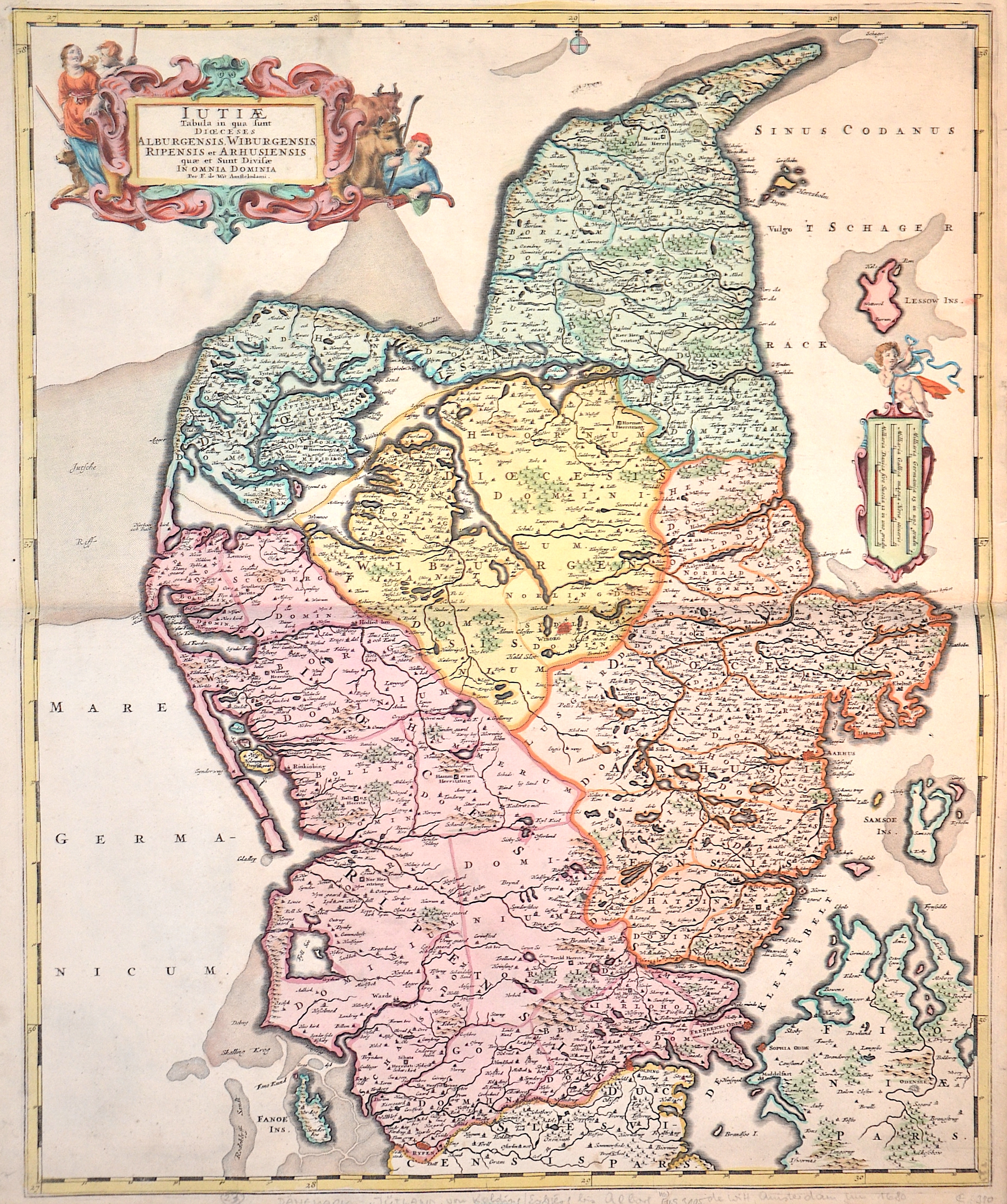
Iutiae Tabula in qua sunt Dioeces Alburgensis, Wiburgensis, Ripensis et Arhusiensis..

| Article ID | EUS3105 |
Title | Iutiae Tabula in qua sunt Dioeces Alburgensis, Wiburgensis, Ripensis et Arhusiensis.. |
Description | Map shows Jutland the western part of Denmark, magnificent cartouche and mileage indicator with putto. It is located on the Kimbrian Peninsula and extends from the Danish border between Germany and Denmark to the Grenen Peninsula north of Skagen. Thus Jutland forms the Danish mainland, all other parts of Denmark are on islands. Until 1864, the southern border of Denmark was the southern border of the Duchy of Schleswig, which extended roughly from Kiel to the mouth of the Eider River near Tönning, the so-called Eider border.Since 1920, the Danish southern border has been a connecting line from Flensburg to Margretekoog in Denmark. |
| Year | ca. 1680 |
Artist | Wit, de (1610-1698) |
Frederik de Wit (1610 – 1698). His Atlas began to appear around 1662 and by 1671 included anywhere from 17 to 151 maps each. In the 1690s he began to use a new title page "Atlas Maior" but continued to use his old title page. His atlas of the Low Countries first published in 1667,was named Nieuw Kaertboeck van de XVII Nederlandse Provinciën and contained 14 to 25 maps. Frederik de Wit quickly expanded upon his first small folio atlas which contained mostly maps printed from plates that he had acquired, to an atlas with 27 maps engraved by or for him. By 1671 he was publishing a large folio atlas with as many as 100 maps. Smaller atlases of 17 or 27 or 51 maps could still be purchased and by the mid-1670s an atlas of as many as 151 maps and charts could be purchased from his shop. In ca.1675 Frederik de Wit released a new nautical atlas. The charts in this atlas replaced the earlier charts from 1664 that are known today in only four bound examples and a few loose copies. Frederik de Wit new charts were sold in a chart book and as part of his atlases. Frederik de Wit published no fewer than 158 land maps and 43 charts on separate folio sheets. In 1695 Frederik de Wit began to publish a town atlas of the Netherlands after he acquired a large number of city plans at the auction of the famous Blaeu publishing firm’s printing plates. Dating Frederik de Wit atlases is considered difficult because usually no dates were recorded on the maps and their dates of publication extended over many years. | |
| Place of Publication | Amsterdam |
| Dimensions (cm) | 57,5 x 47,5 |
| Condition | Perfect condition |
| Coloring | original colored |
| Technique | Copper print |