

Adina Sommer
Antique and Contemporary Art
Winzerer Str. 154
80797 München
telephone
+49 89 304714
business hours:
by appointment
Email
![]()


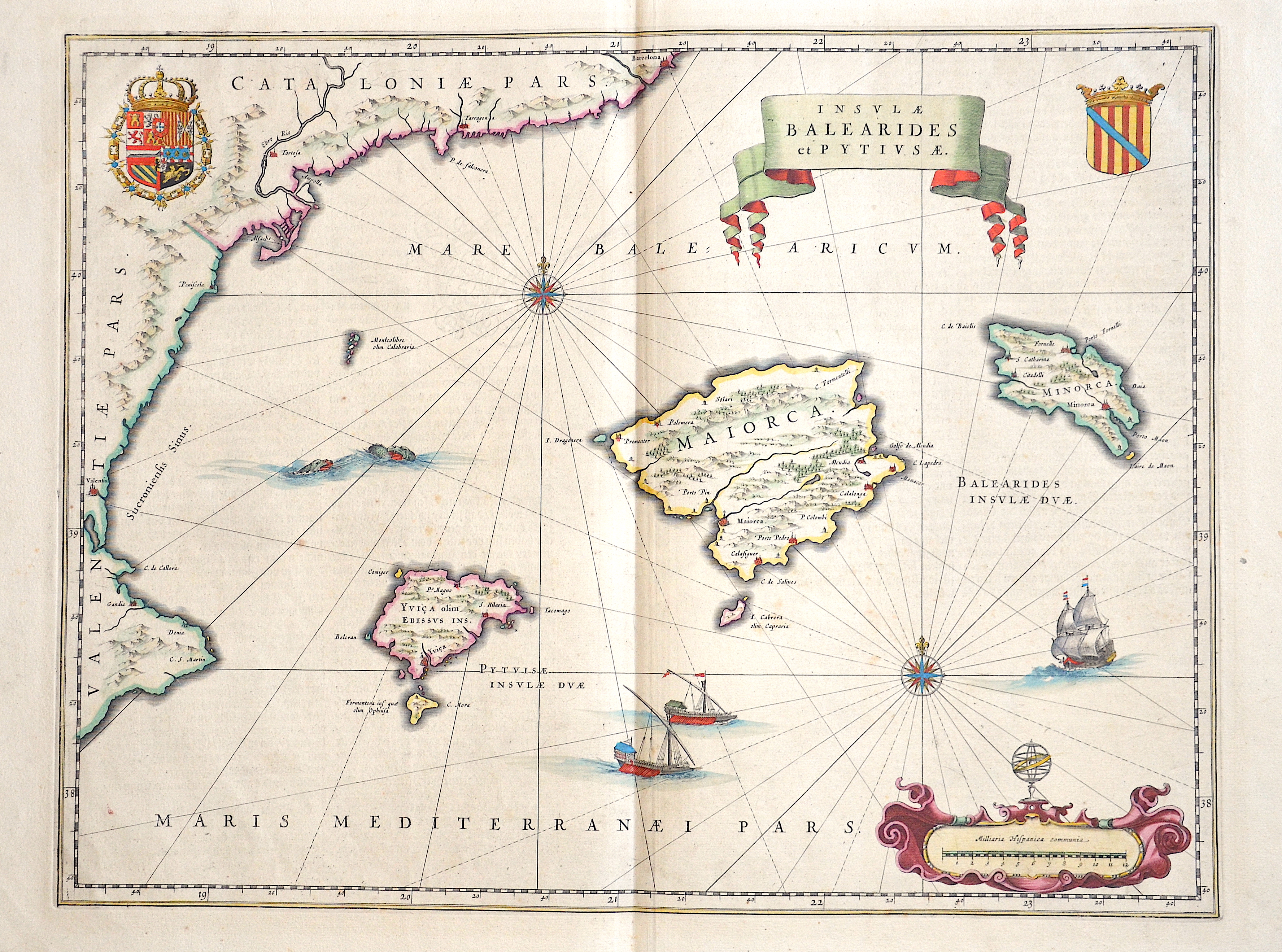
Insulae Balearides et Pytivsae.

| Article ID | EUE4367 |
Title | Insulae Balearides et Pytivsae. |
Description | Magnificent map shows the Spanish islands of Mallorca, Menorca, Ibiza, the coast of Valencia and Catalonia. Furthermore two cartridges, two coats of arms, a wind rose, sea monsters and sailing ships. |
| Year | ca. 1640 |
Artist | Blaeu (1571-1638) |
Joan Guilliemus Blaeu was the eldest son of Willem Janszoon Blaeu (1571-1638), and was probably born in Alkmaar in the province of Noord-Holland in the final years of the 16th century. He was brought up in Amsterdam, and studied law at the University of Leiden before going into partnership with his father in the 1630s. Although his father Willem had cartographic interests, having studied under the Danish astronomer Tycho Brahe and having manufactured globes and instruments, his primary business was as a printer. It was under the control of Joan that the Blaeu printing press achieved lasting fame by moving towards the printing of maps and expanding to become the largest printing press in Europe in the 17th century. By the 1660s the Theatrum Orbis Terrarum (or Atlas Maior as it had became known by this time) had expanded to between 9 and 12 volumes, depending on the language. With over 3,000 text pages and approximately 600 maps, it was the most expensive book money could buy in the later 17th century. The translation of the text from Latin into Dutch, English, German, French, and Spanish for several volumes created enormous work for those involved in typography and letterpress activities. It is estimated that over 80 men must have been employed full-time in the Blaeu printing house in Bloemgracht, not including engravers who worked elsewhere, with over 15 printing presses running simultaneously, and in 1667 a second press was acquired at Gravenstraat. At the same time as producing the Atlas Maior, Blaeu was also publishing town plans of Italy, maps for globes, and other volumes. At its peak the Blaeu press managed to produce over 1 million impressions from 1,000 copper plates within four years. | |
Historical Description | The indigenous population of the Balearic Islands probably immigrated from the Iberian Peninsula or today's southern France. In ancient times, the islands were called Balearides or Gymnesiae, which meant the islands of Mallorca (Balearis major) and Menorca (Balearis minor). At first they were dependent on the Phoenicians. Mallorca and Ibiza were conquered in 1229 and 1235 respectively by Jacob I of Aragon (Catalan Jaume I), Menorca by his descendant Alfonso III. The Balearic Islands, like Catalonia, now belonged to the Aragon Crown. At times, together with parts of Catalonia, they formed an independent state, the Kingdom of Mallorca, ruled by a branch of the Aragonese royal family. In 1708 Maó was conquered by the British. The Peace of Utrecht (1713), which ended the War of Spanish Succession, gave Menorca to the British Empire. This had to return the island to Spain in the Treaty of Versailles (1783), but remained British until 1802. The Spanish province of the Balearic Islands was founded in 1833. |
| Place of Publication | Amsterdam |
| Dimensions (cm) | 38 x 50 cm |
| Condition | Perfect condition |
| Coloring | original colored |
| Technique | Copper print |