

Adina Sommer
Antique and Contemporary Art
Winzerer Str. 154
80797 München
telephone
+49 89 304714
business hours:
by appointment
Email
![]()


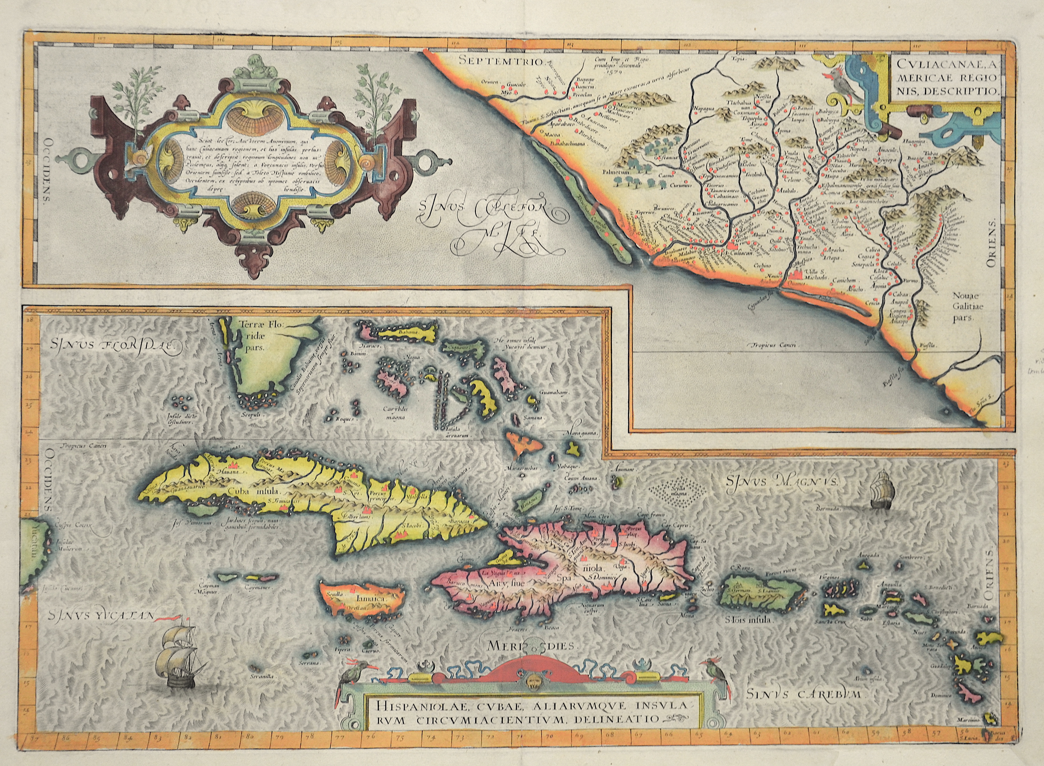
Hispaniolae Cubae aliarumque insularum…

| Article ID | AMW141 |
Title | Hispaniolae Cubae aliarumque insularum… |
Description | Map shows on two inset maps, the coast of Mexico, Cuba and Hispaniola.1st edition. Rare edition due to a printing error. The Meridian Capricorn (Tropicus Capricorn) was wrongly printed, the Merdian in the sign of Keb (Tropicus Canceri) would be correct! |
| Year | c. 1579 |
Artist | Ortelius (1527-1598) |
Abraham Ortelius (1527–1598) was a Flemish cartographer and publisher from Antwerp. Originally a map colorist, he became a major figure in cartography through his Theatrum Orbis Terrarum (1570), considered the first modern atlas—a uniform collection of reliable maps in book form. Influenced by Gerardus Mercator, Ortelius published several maps before compiling the Theatrum, which clearly showed America as a separate continent. The work was published in 42 editions and 7 languages by 1612. Unlike many of his peers, Ortelius cited his sources, and his atlas became a milestone in mapmaking and geographic knowledge. | |
Historical Description | The Caribbean is named after the Caribs people, which the Spanish conquerors found in the Lesser Antilles (lat. Ante ilium, "offshore islands"). It was also called the West Indies because it was believed to have been discovered by sea directly to India. Before the discoveries in the 1st millennium BC Arawak Indians came from Venezuela to the Caribbean Islands. They spread northwards through Trinidad. They were followed around 1500 years later by the warlike Caribs, which the Arawak slowly pushed away from the Lesser Antilles. At the time of Christopher Columbus' voyages of discovery, the Arawak inhabited the islands of Cuba, Hispaniola and the Bahamas, while the Caribs lived in the Lesser Antilles. When Columbus landed in San Salvador (Bahamas) on behalf of the Spanish crown in 1492, he was primarily looking for gold and other riches. But the Arawak did not care what Europeans saw as wealth. So the Caribbean was settled, but the conquistadors soon moved to the American continent. Gradually, English, Dutch and French settled. Even Denmark, Sweden and Courland were owned by some colonies. St. Barthélemy was for excample. almost a century under Swedish rule. Many of the native Indians eventually fell victim to introduced diseases or slavery. The Caribbean was particularly active in the 17th and early 18th centuries for Buccaneers and Pirates (so-called Golden Age of Piracy). The small islands offered the pirates, some of whom were privateers commissioned by a king, numerous shelters, and the Spanish treasure fleets were a good and worthwhile target. Port Royal in Jamaica and the French settlement on Tortuga were real pirate settlements. |
| Place of Publication | Antwerp |
| Dimensions (cm) | 35 x 50 |
| Condition | Very good |
| Coloring | original colored |
| Technique | Copper print |