

Adina Sommer
Antique and Contemporary Art
Winzerer Str. 154
80797 München
telephone
+49 89 304714
business hours:
by appointment
Email
![]()


Guinea

| Article ID | AF0648 |
Title | Guinea |
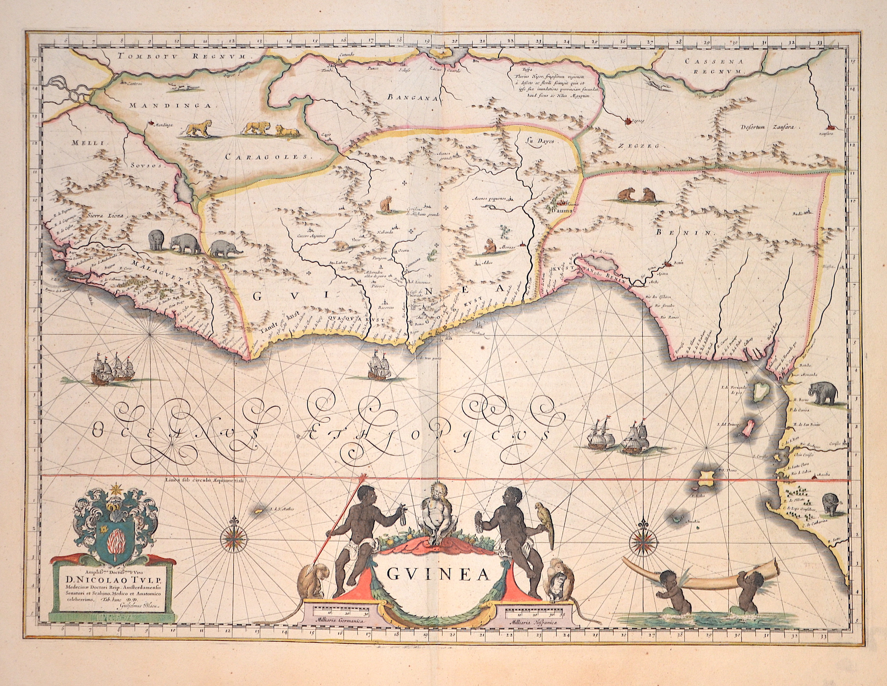
Description | Very nice map of the Gulf of Guinea with many animal staffages in the country as well as offshore sailing ships, two wind roses and a title cartouche with natives, pearls, monkeys and a parrot. At the bottom right, two sea turkeys carry an elephant's tusk. A coat of arms and a dedication cartouche at the bottom left explain that the map is dedicated to Dr Nicholas Tulp (1593-1674), a member of the Amsterdam government and famous anatomist. The dedication is not a mere compliment, but an ode to one of the most famous physicians of the seventeenth century. |
| Year | ca. 1635 |
Artist | Blaeu (1571-1638) |
Joan Guilliemus Blaeu was the eldest son of Willem Janszoon Blaeu (1571-1638), and was probably born in Alkmaar in the province of Noord-Holland in the final years of the 16th century. He was brought up in Amsterdam, and studied law at the University of Leiden before going into partnership with his father in the 1630s. Although his father Willem had cartographic interests, having studied under the Danish astronomer Tycho Brahe and having manufactured globes and instruments, his primary business was as a printer. It was under the control of Joan that the Blaeu printing press achieved lasting fame by moving towards the printing of maps and expanding to become the largest printing press in Europe in the 17th century. By the 1660s the Theatrum Orbis Terrarum (or Atlas Maior as it had became known by this time) had expanded to between 9 and 12 volumes, depending on the language. With over 3,000 text pages and approximately 600 maps, it was the most expensive book money could buy in the later 17th century. The translation of the text from Latin into Dutch, English, German, French, and Spanish for several volumes created enormous work for those involved in typography and letterpress activities. It is estimated that over 80 men must have been employed full-time in the Blaeu printing house in Bloemgracht, not including engravers who worked elsewhere, with over 15 printing presses running simultaneously, and in 1667 a second press was acquired at Gravenstraat. At the same time as producing the Atlas Maior, Blaeu was also publishing town plans of Italy, maps for globes, and other volumes. At its peak the Blaeu press managed to produce over 1 million impressions from 1,000 copper plates within four years. | |
Historical Description | Guinea: The land that is now Guinea belonged to a series of African empires until France colonized it in the 1890s, and made it part of French West Africa. Guinea declared its independence from France on 2 October 1958. The country is named after the Guinea region. Guinea is a traditional name for the region of Africa that lies along the Gulf of Guinea. It stretches north through the forested tropical regions and ends at the Sahel. The English term Guinea comes directly from the Portuguese word Guiné, which emerged in the mid-15th century to refer to the lands inhabited by the Guineus, a generic term for the black African peoples south of the Senegal River, in contrast to the "tawny" Zenaga Berbers above it, whom they called Azenegues or Moors. |
| Place of Publication | Amsterdam |
| Dimensions (cm) | 38,5 x 52,5 cm |
| Condition | Perfect condition |
| Coloring | original colored |
| Technique | Copper print |