

Adina Sommer
Antique and Contemporary Art
Winzerer Str. 154
80797 München
telephone
+49 89 304714
business hours:
by appointment
Email
![]()


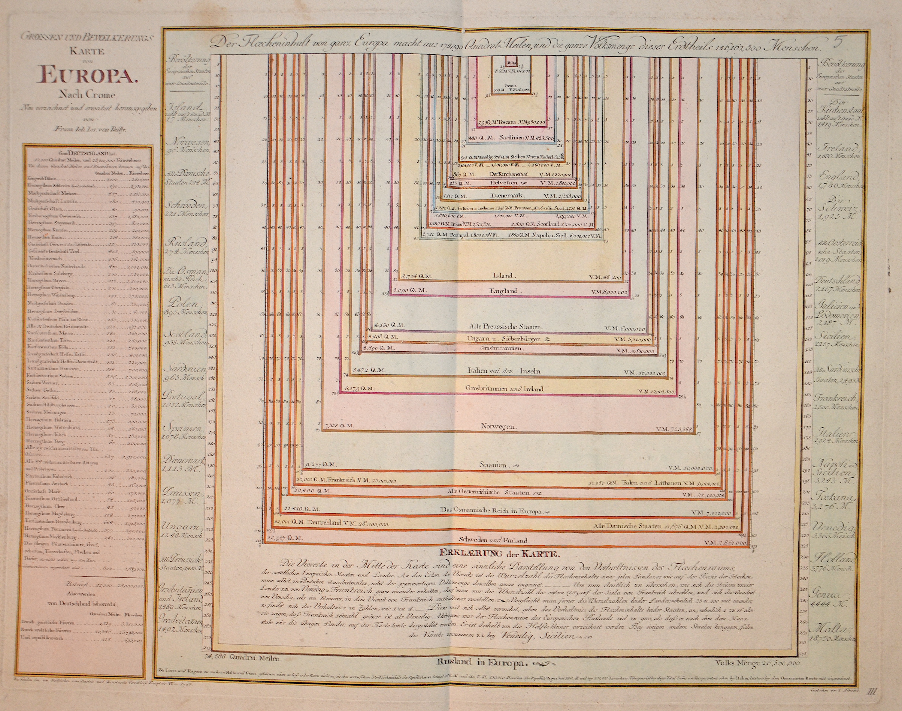
Grössen und Bevölkerungs Karte von Europa

| Article ID | T008 |
Title | Grössen und Bevölkerungs Karte von Europa |
Description | map with the area and population of European countries. |
| Year | ca. 1790 |
Artist | Reilly (1766-1820) |
Franz Johann Joseph von Reilly (1766 - 1820) Vienna. Franz Johann Joseph von Reilly was an Austrian publisher, cartographer and writer. He was born the son of the court master Johann Reilly. He initially worked in the civil service, but then devoted himself exclusively to geography. From 1789 to 1806, he produced the atlas Schauplatz der fünf Theile der Welt, which only covers Europe on its 830 sheets. After the Schul Atlas (1791-92) and the Allgemeine Erdbeschreibung (3 volumes, 1792-93), he published the first (complete) Austrian world atlas entitled Grosser deutscher Atlas from 1794 to 1796. In 1796, he produced the series Geschichtliche und bildliche Vorstellung der Regimenter des Erzhauses Oesterreich (Historical and Pictorial Presentation of the Regiments of the Archduke of Austria), and in 1799 the Allgemeine Post Atlas von der ganzen Welt (General Postal Atlas of the Whole World) - the first atlas of its kind in the world. | |
Historical Description | The history of Europe from the 15th to the 19th century was shaped by profound political, social, and cultural changes that formed modern Europe. At the beginning of the 15th century, Europe was marked by the effects of the Middle Ages and the feudal structure. A significant event was the Renaissance, which began around 1400 in Italy and marked a revival of classical ancient culture, art, and sciences. The invention of the printing press by Johannes Gutenberg around 1440 was also revolutionary and promoted the spread of knowledge. By the end of the century, European explorers, such as Christopher Columbus, began finding new trade routes, which led to the discovery of the New World. The 16th century was defined by the Reformation, when Martin Luther published his 95 Theses in 1517, challenging the Catholic Church. This led to religious conflicts and the division of Western Christianity into Catholics and Protestants. Politically, Europe saw the rise of the Habsburg Empire and the development of nation-states such as France and England. The age of exploration continued, leading to a new wave of colonization. The 17th century was a time of wars and political instability, including the Thirty Years' War (1618–1648), which devastated much of Europe. These conflicts resulted in significant territorial changes and the establishment of the modern Treaty of Westphalia in 1648. During this time, Absolutism took root, with monarchs like Louis XIV of France exercising absolute power. The 18th century was marked by the ideas of the Enlightenment, which emphasized reason, science, and individual freedom. This led to profound political and social reforms. At the same time, major wars such as the War of Spanish Succession (1701–1714) and the Seven Years' War (1756–1763) took place. The century ended with the events of the French Revolution (1789), which overthrew the monarchy and established the Republic. This paved the way for the Napoleonic Wars and the Napoleonic Era, which triggered political and social upheavals throughout Europe. The 19th century was shaped by the aftermath of the French Revolution and the Napoleonic Wars, which reshaped Europe's political system. After Napoleon's defeat in 1815, Europe was reorganized at the Congress of Vienna. Nationalism and Liberalism grew, leading to significant political upheavals, including the German Confederation, the unification of Italy, and the formation of the German Empire in 1871. At the same time, industrialization and urbanization began, significantly altering Europe's economic and social structure. The 19th century ended with the outbreak of World War I in 1914, which shattered the entire European power structure and many social systems. |
| Place of Publication | Vienna |
| Dimensions (cm) | 48 x 62 cm |
| Condition | Stain upper left |
| Coloring | colored |
| Technique | Copper print |