

Adina Sommer
Antique and Contemporary Art
Winzerer Str. 154
80797 München
telephone
+49 89 304714
business hours:
by appointment
Email
![]()


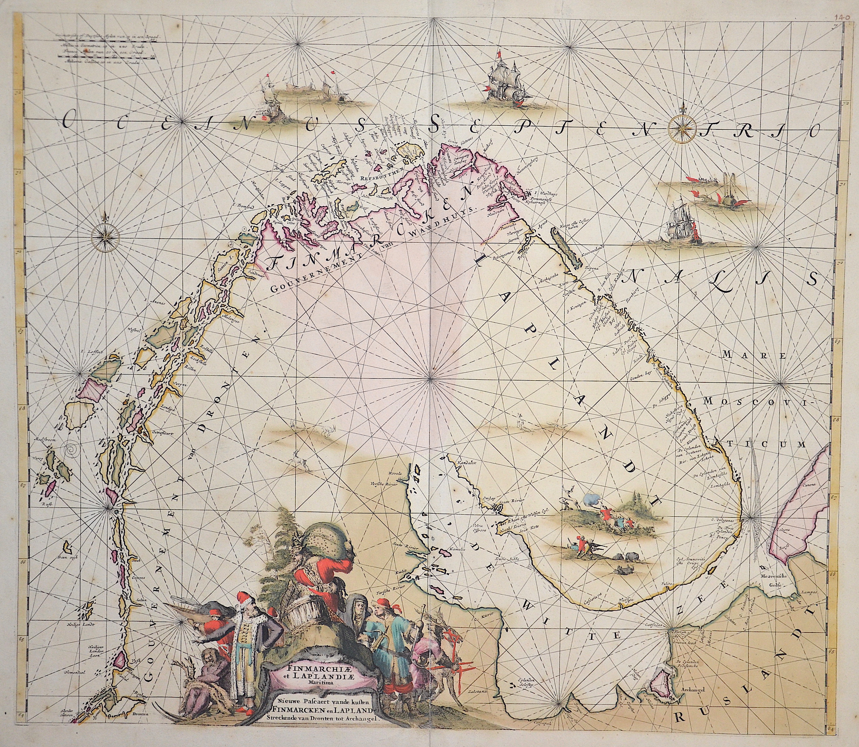
Finnmarchiae et Lapplandiae Maritima

| Article ID | EUS774 |
Title | Finnmarchiae et Lapplandiae Maritima |
Description | Map shows the Nothpole Sea with Lappland parts of Finnalnd and Norwege. Die Anrainerstaaten der Ostsee sind Deutschland, Dänemark, Schweden, Finnland, Russland, Estland, Lettland, Litauen und Polen. |
| Year | ca. 1739 |
Artist | Wit, de (1610-1698) |
Frederik de Wit (1610 – 1698). His Atlas began to appear around 1662 and by 1671 included anywhere from 17 to 151 maps each. In the 1690s he began to use a new title page "Atlas Maior" but continued to use his old title page. His atlas of the Low Countries first published in 1667,was named Nieuw Kaertboeck van de XVII Nederlandse Provinciën and contained 14 to 25 maps. Frederik de Wit quickly expanded upon his first small folio atlas which contained mostly maps printed from plates that he had acquired, to an atlas with 27 maps engraved by or for him. By 1671 he was publishing a large folio atlas with as many as 100 maps. Smaller atlases of 17 or 27 or 51 maps could still be purchased and by the mid-1670s an atlas of as many as 151 maps and charts could be purchased from his shop. In ca.1675 Frederik de Wit released a new nautical atlas. The charts in this atlas replaced the earlier charts from 1664 that are known today in only four bound examples and a few loose copies. Frederik de Wit new charts were sold in a chart book and as part of his atlases. Frederik de Wit published no fewer than 158 land maps and 43 charts on separate folio sheets. In 1695 Frederik de Wit began to publish a town atlas of the Netherlands after he acquired a large number of city plans at the auction of the famous Blaeu publishing firm’s printing plates. Dating Frederik de Wit atlases is considered difficult because usually no dates were recorded on the maps and their dates of publication extended over many years. | |
Historical Description | The Baltic Sea, internationally known as the Baltic Sea (v Mare Balticum), is an inland sea of the Atlantic Ocean in Europe and, unlike the North Sea, is not a marginal sea of this ocean. It is predominantly a brackish sea, whereby a higher salt and oxygen content can be observed in the western Baltic Sea due to the water exchange with the Atlantic and North Sea. The countries bordering the Baltic Sea are Germany, Denmark, Sweden, Finland, Russia, Estonia, Latvia, Lithuania and Poland. Historically, the border ran through the Belt Sea, as the Kingdom of Denmark levied the Sund toll at the entrances to the Baltic Sea. The toll station in the Öresund was Kronborg Castle near Helsingør. In the Great Belt, it was collected at Nyborg. For the Little Belt, the Sundzoll was called the Stromzoll or Beltzoll and was levied there since the founding of the fortress of Fredericia in 1650. |
| Place of Publication | Amsterdam |
| Dimensions (cm) | 50 x 57 |
| Condition | Some restorations |
| Coloring | original colored |
| Technique | Copper print |