

Adina Sommer
Antique and Contemporary Art
Winzerer Str. 154
80797 München
telephone
+49 89 304714
business hours:
by appointment
Email
![]()


Eastern Hemisphere
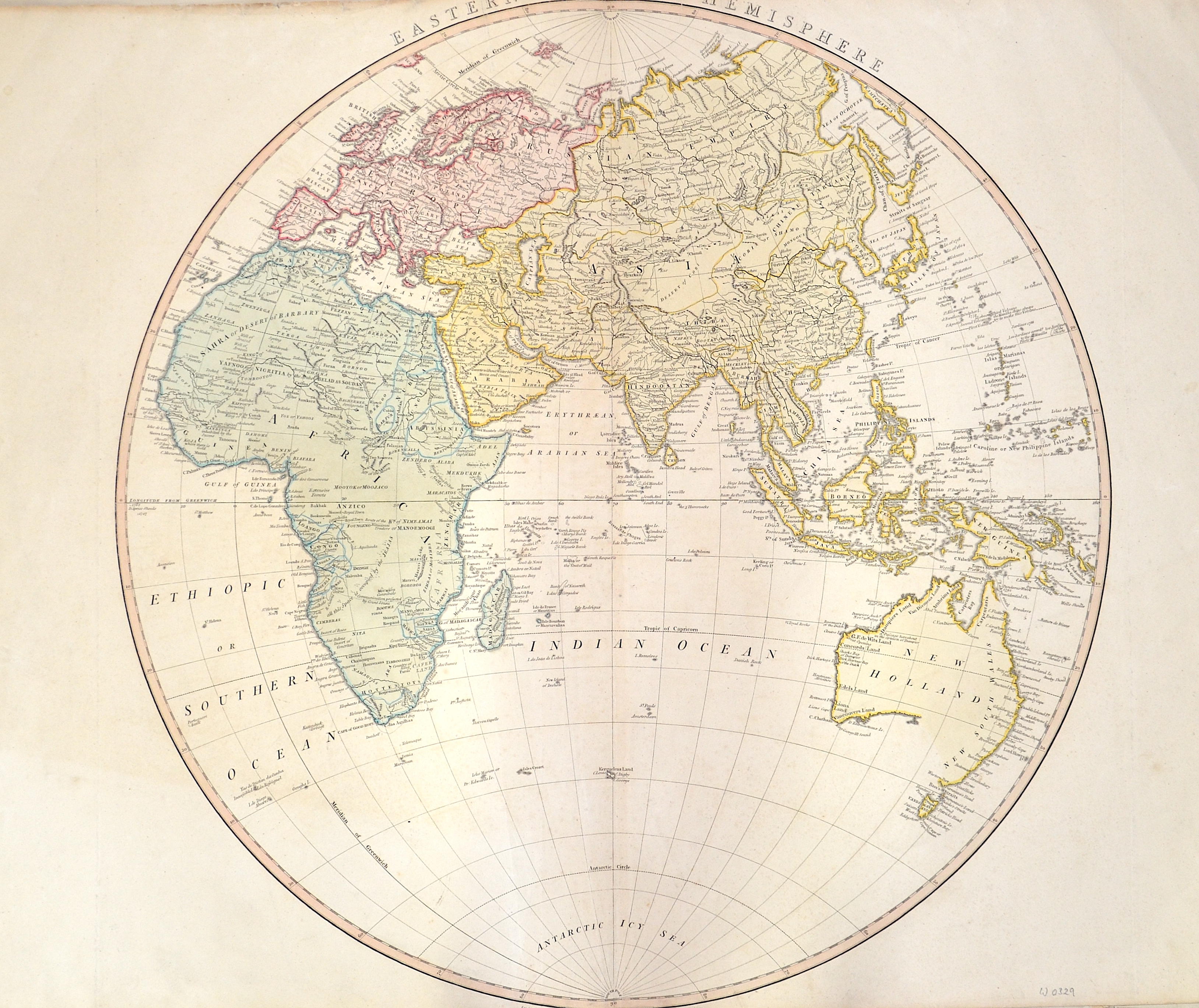

| Article ID | W0329 |
Title | Eastern Hemisphere |
Description | Map shows the eastern hemisphere with Europe, Africa, Asia, Southeast Asia and Australia. |
| Year | ca. 1790 |
Artist | Faden (1749-1836) |
William Faden (1749 – 1836) was an English cartographer and a publisher of maps. He was the royal geographer to King George III. He replaced Thomas Jeffreys in that role.The title of -geographer to the king- was given to various people in the 18th century, including John Senex, Herman Moll, Emmanuel Bowen and Thomas Jeffreys. All of these men, including William Faden, were engravers and publishers, not scholars or academics. Their part was to publish and supply maps to the crown and parliament. William Faden printed the North American Atlas in 1777, and ""...it became the most important atlas chronicling the Revolution's battles."" There were 29 maps in the atlas, and they included detailed battle maps drawn by eyewitnesses. | |
Historical Description | Popular science refers to the period from about the 15th to the 18th centuries. The era is considered to be in the early modern period and is primarily concerned with the knowledge of seafarers and explorers. The idea of the age of discoveries is shaped by seafaring and discoveries overseas. In terms of content, however, it also includes astronomy, which is associated with the names of Tycho Brahe, Nikolaus Kopernikus, Isaac Newton and Johannes Kepler, among others. Giordano Bruno and Galileo Galilei also belong to this group. Not only the seafarers with their discoveries, but also they brought about changes in the world view. Some motifs were religious, e.g. B. that Christianity should be spread in the New World (missionary). The great European powers also expected an expansion of their political sphere of influence. This is evident in the overseas colonies, including the Spaniards, Portuguese, English, Dutch and French. The Tordesillas Treaty of 1494 is an example of this. It regulated the distribution of the discovered countries between Portugal and Spain. Global exploration began with the Portuguese discoveries of the Atlantic archipelagos of Madeira and the Azores in 1419 and 1427, the African coast after 1434, and the sea route to India in 1498; and from the Crown of Castile (Spain) the transatlantic trips of Christopher Columbus to America between 1492 and 1502 and the first world tour in the years 1519–1522. These discoveries led to numerous naval expeditions across the Atlantic, Indian and Pacific Oceans, and land expeditions in America, Asia, Africa, and Australia that continued into the late 19th century, followed by exploration of the polar regions in the 20th century. European overseas exploration led to the rise of world trade and the European colonial empires, with contact between the Old World (Europe, Asia and Africa) and the New World (America and Australia) creating Colombian exchange, a wide range of plant transfers, animals, and food , human populations (including slaves), communicable diseases and culture between the Eastern and Western Hemisphere. The age of discovery and later exploration of Europe made it possible to map the world, which led to a new worldview and distant civilizations, but also to the spread of diseases that decimated populations that were not previously in contact with Eurasia and Africa, and to enslavement , Exploitation, military conquest and economic dominance of Europe and its colonies over indigenous people. It also allowed the expansion of Christianity. |
| Place of Publication | London |
| Dimensions (cm) | 58,5 x 57 cm |
| Condition | Perfect condition |
| Coloring | original colored |
| Technique | Copper print |