

Adina Sommer
Antique and Contemporary Art
Winzerer Str. 154
80797 München
telephone
+49 89 304714
business hours:
by appointment
Email
![]()


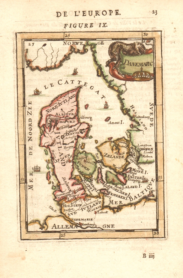
De L’Europe. Figure IX. Danemarc

| Article ID | EUS3905 |
Title | De L’Europe. Figure IX. Danemarc |
Description | Map shows total Denmark with Jutland, Funen, Zealand, Lolland-Falster, etc. and the traditional provinces of Sweden Halland, Scania, Blekinge and the Dutsch of Holstein it's was the northernmost state of the Holy Roman Empire, located in the present German state of Schleswig-Holstein. |
| Year | ca. 1683 |
Artist | Mallet (1630-1706) |
Alain Manesson Mallet (1630- 1706 ) was a French cartographer and engineer. He started his career as a soldier in the army of Louis XIV, became a Sergeant-Major in the artillery and an Inspector of Fortifications. He also served under the King of Portugal, before returning to France, and his appointment to the court of Louis XIV. His military engineering and mathematical background led to his position teaching mathematics at court. His major publications were Description de L'Univers (1683) in 5 volumes, and Les Travaux de Mars ou l'Art de la Guerre (1684) in 3 volumes. His Description de L'Universe contains a wide variety of information, including star maps, maps of the ancient and modern world, and a synopsis of the customs, religion and government of the many nations included in his text. It has been suggested that his background as a teacher led to his being concerned with entertaining his readers. This concern manifested itself in the charming harbor scenes and rural landscapes that he included beneath his description of astronomical concepts and diagrams. Mallet himself drew most of the figures that were engraved for this book. | |
Historical Description | Denmark is a country and sovereign state in Northern Europe and a parliamentary monarchy. Denmark is officially called the Kingdom of Denmark along with the Faroe Islands, which geographically belong to Northern Europe, like the mother country, and Greenland, which belongs to North America. The Danish people are said to have come from Scania to Jutland and the western Baltic islands in the 6th century, where they displaced other Germanic tribes. In the 10th century, Gorm the Old (around 950) united the individual minor kingdoms under his rule. Until 1035, when Knut the Great died, the Danish kings succeeded in conquering large parts of the British Isles. Until well into the 11th century, the Danes, Swedes and Norwegians, among others, were called Vikings, who founded colonies and traded throughout Europe. The only land border is between Denmark and Germany. A Danish minority lives in the former Danish southern Schleswig. With the Kalmar Union, Halland was suddenly in the center of the Danish Empire and, according to the Union Treaty, Erich of Pomerania should have been crowned in Halmstad. In the period that followed, Halland was not spared the wars of the era. In 1434, the landscape was conquered by the fighters of the Engelbrekt uprising and the Falkenberg castle was burned down. In the course of the Three Crown War, the Battle of Axtorna (also: Battle on the Falkenberger Haide) took place here in 1565, during which the Danish general Rantzau defeated a superior Swedish army. Until 1645 Halland belonged to Denmark and was then awarded in the peace of Brömsebro to Sweden for 30 years. Since the Peace of Roskilde in 1658, Halland has finally belonged to Sweden, although Denmark tried again in the Schoen War (1675–1679) to recapture lost territory. |
| Place of Publication | Paris |
| Dimensions (cm) | 16 x 10 |
| Condition | Perfect condition |
| Coloring | original colored |
| Technique | Copper print |