

Adina Sommer
Antique and Contemporary Art
Winzerer Str. 154
80797 München
telephone
+49 89 304714
business hours:
by appointment
Email
![]()


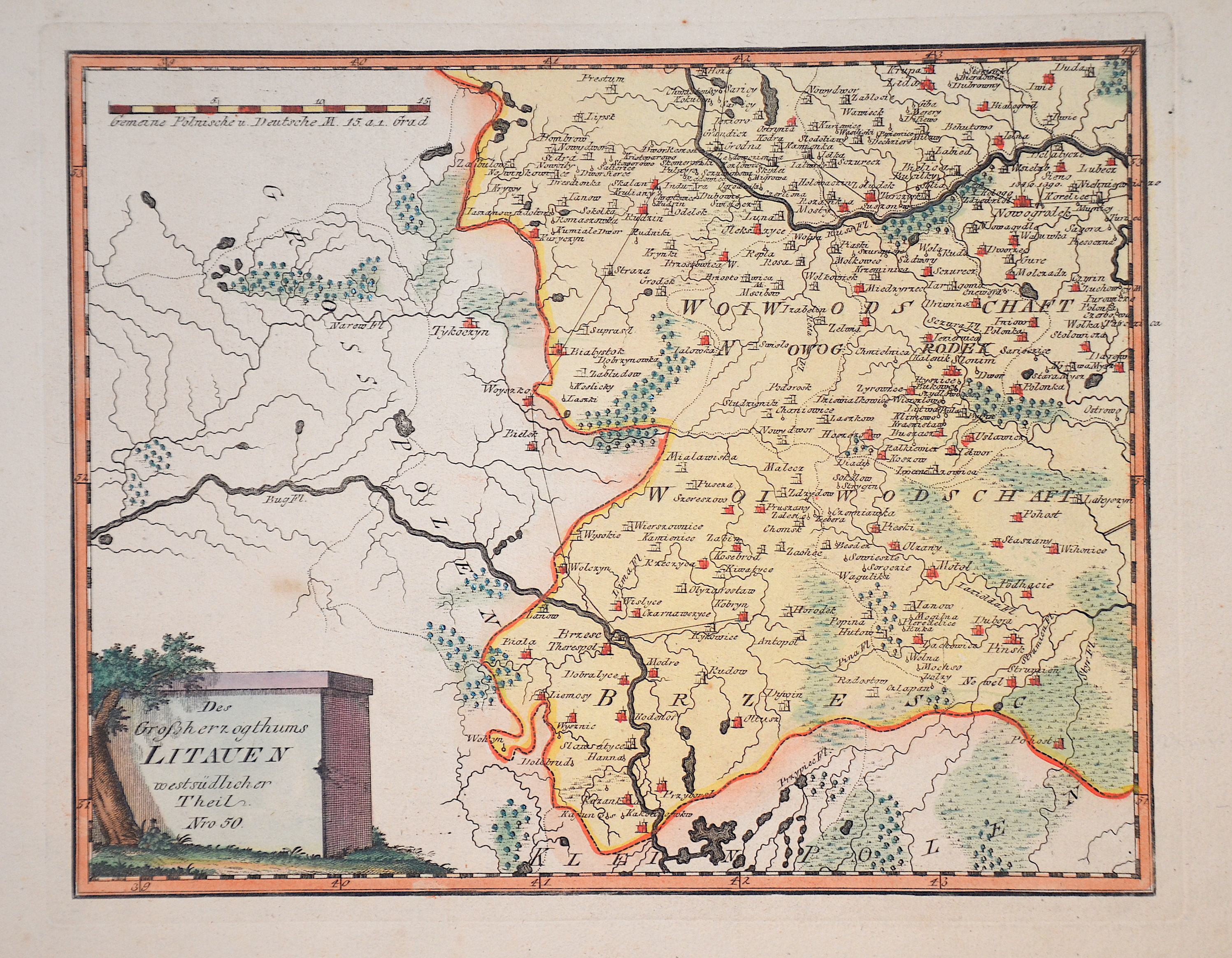
Das Großherzogthums Litauen westsüdlicher Theil. Nro 50.

| Article ID | EUL3299 |
Title | Das Großherzogthums Litauen westsüdlicher Theil. Nro 50. |
Description | Map shows the Brześć Litowski Voivodeship and the Nowogrodek Voivodeship in the Grand Duchy of Lithuania between the Bug and Memel rivers. In the north the towns of Grodno (Hrordna) and Nowogrodek (Nawahradak) in present-day Belarus, in the south Brest and Saritschne (Pohost) on the Ukrainian border. The Podolia Voivodeship was an administrative unit in the province of Lesser Poland of the Kingdom of Poland-Lithuania. |
| Year | ca. 1791 |
Artist | Reilly (1766-1820) |
Franz Johann Joseph von Reilly (1766 - 1820) Vienna. Franz Johann Joseph von Reilly was an Austrian publisher, cartographer and writer. He was born the son of the court master Johann Reilly. He initially worked in the civil service, but then devoted himself exclusively to geography. From 1789 to 1806, he produced the atlas Schauplatz der fünf Theile der Welt, which only covers Europe on its 830 sheets. After the Schul Atlas (1791-92) and the Allgemeine Erdbeschreibung (3 volumes, 1792-93), he published the first (complete) Austrian world atlas entitled Grosser deutscher Atlas from 1794 to 1796. In 1796, he produced the series Geschichtliche und bildliche Vorstellung der Regimenter des Erzhauses Oesterreich (Historical and Pictorial Presentation of the Regiments of the Archduke of Austria), and in 1799 the Allgemeine Post Atlas von der ganzen Welt (General Postal Atlas of the Whole World) - the first atlas of its kind in the world. | |
Historical Description | he beginning of Lithuania as a state lies in the 13th century. Prince Mindaugas, who even had himself crowned king in 1253 with the Pope's approval, brought the neighboring tribes under his sovereignty by military force. At his death in 1263, his principality/kingdom encompassed approximately the area of present-day Lithuania. Parallel to this, the expansion to the east already took place in the 14th century. From the disintegration of the old Kievan Rus after the Mongol storm until 1240 several successor principalities had developed. Lithuania was prevented from pursuing an expansive western policy by the Teutonic Order, while the eastern flank lay open due to the Tatar invasion. The Grand Duchy of Lithuania advanced into this power vacuum and, with the conquest of Kiev (after 1362), came into competition with the Grand Duchy of Moscow for supremacy among the constituent principalities of Rus. Lithuanian eastward expansion reached its peak in the first half of the 15th century. The close political union of Poland and Lithuania resulted in the Real Union of Lublin in 1569, which meant the end of independent Lithuania, after the Lithuanian nobility had already increasingly come under the influence of Polish culture and language in the preceding decades. Thus, during the Reformation, Lithuania went the Polish way and remained Catholic, while the northern, German-influenced Baltic became Protestant. Lithuania remained with the Polish state until the partitions of Poland and then came under Russian rule in 1795. In the wake of perestroika, which triggered the Singing Revolution in the Baltics, Lithuania became the first union republic of the Soviet Union to declare itself a sovereign state in 1990 and renamed the Supreme Soviet the Constituent Assembly. |
| Place of Publication | Vienna |
| Dimensions (cm) | 23 x 29 cm |
| Condition | Perfect condition |
| Coloring | colored |
| Technique | Copper print |