

Adina Sommer
Antique and Contemporary Art
Winzerer Str. 154
80797 München
telephone
+49 89 304714
business hours:
by appointment
Email
![]()


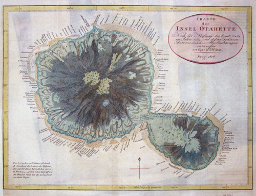
Charte der Insel Otaheite

| Article ID | OZ0261 |
Title | Charte der Insel Otaheite |
Description | Map shows the islands of Tahiti. The Society Islands in French Polonesia. The archipelago is suspected to have been named by Captain James Cook during his first voyage in 1769, supposedly in honour of the Royal Society, the sponsor of the first British scientific survey of the islands. However, Cook himself stated in his journal that he called the islands Society ;as they lay contiguous to one another. |
| Year | dated 1816 |
Artist | Willson |
Historical Description | Tahiti was settled - like the other Society Islands - around 200 BC from Tonga and Samoa. It is not conclusively clear which European can be considered the "discoverer" of Tahiti. The Portuguese Pedro Fernández de Quirós sighted an inhabited island in 1606, which he called Sagittaria and which, according to some chroniclers, could have been Tahiti. However, there is no confirmation of this. Today, the Englishman Samuel Wallis is considered the first European to set foot on Tahiti in 1767. The visits of James Cook have remained in the consciousness of Europeans. In April 1769 he anchored with his ship Endeavour in Matavai Bay, about 10 km north of today's Papeete. Traveling with Cook was botanist Joseph Banks, who conducted extensive botanical studies during his three-month stay. His findings led to the fateful 1787 voyage of the Bounty to Tahiti, which was commissioned by the British Admiralty to William Bligh. |
| Place of Publication | Prag |
| Dimensions (cm) | 28 x 37 |
| Condition | Tear on the left side perfectly restored |
| Coloring | colored |
| Technique | Copper print |