

Adina Sommer
Antique and Contemporary Art
Winzerer Str. 154
80797 München
telephone
+49 89 304714
business hours:
by appointment
Email
![]()


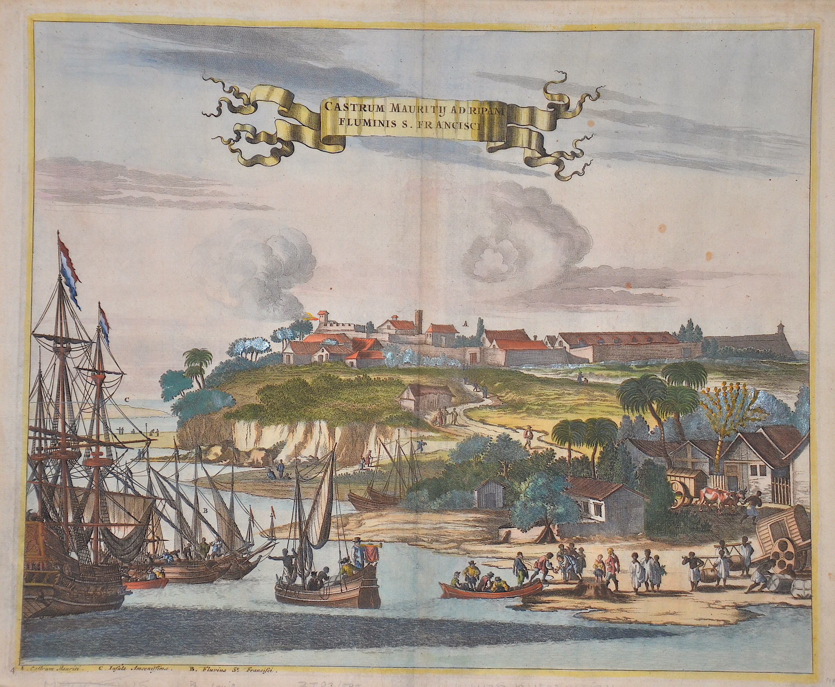
Castrum Mauritii ad ripam fluminis S. Francisci

| Article ID | AF0223 |
Title | Castrum Mauritii ad ripam fluminis S. Francisci |
Description | Depiction of the Rio Sao Francisco and Fort Maurice in Brazil. This is from John Ogilby's America: being the latest, and most accurate description of the New World ... Collected from most authentic authors, supplemented with later observations, and embellished with maps and sculptures, by John Ogilby. The first edition of this work was published by Ogilby in London in 1671. It is the first English edition after Arnoldus Montanus' De Nieuwe en Onbekende Weereld, to which Ogilby added a number of references to New England, New France, Maryland and Virginia. |
| Year | ca. 1671 |
Artist | Ogilby (1600-1676) |
John Ogilby was a Scottish translator, impresario and cartographer. Best known for publishing the first British road atlas, he was also a successful translator, noted for publishing his work in handsome illustrated editions. John Ogilby's career as a publisher and printer was gradual. The first editions of his Virgil and Aesop transmissions were published by John and Andrew Crook, both of whom were known for the poor quality of their printed works. His edition of Virgil's works, printed in 1654, was already a splendid volume, of which Ogilby wrote jubilantly that it was "the most beautiful that English printing can boast of so far". Ogilby had financed the printing of the lavish Virgil edition with a method that was hardly known until then, the subscription. To illustrate the work, he had one hundred full-page copperplate engravings made based on designs by the renowned painter Francis Cleyn. Subscribers could then have each individual engraving marked with their name, rank and coat of arms on the lower edge of the picture for a fee and in this way demonstrate their love of art on display. In this way, Ogilby could not only pay for the high manufacturing costs, but also satisfy the vanity of his subscribers. The financing of publishing projects through subscription was still new and little tried at the time - alongside the London publisher Richard Blome, Ogilby was one of the pioneers of subscription in the English publishing business of the 17th century. John Ogilby's -Arnold Montanus (1625-1683) Montanus' De Nieuwe en Onbekende Weereld (The New and Unknown World) appeared in 1673, first published by the Dutch doctor and historian Olfert Dapper (Amsterdam) and later by John Ogilby (Amsterdam) has been. This work is also a treasure trove for materials on America. It contains, among other things, maps of Virginia, Carolina, New England, America (with California as an island), Bermuda, Brazil, Peru, Venezuela, Chile, Paraguay. The copper engravings include an early view of New York, as well as views of Mexico, Carolina, Terceira, Puerto Rico (Porto Rico), Santo Domingo, Havana, St. Augustine / Florida, St. Martin, Campeche, Acapulco, Cartagena Trujillo in Honduras, Callao de Lima, Bay de Todos os Sanctus in Bahia / Brazil, San Salvador, Tamaraca, Olinda de Phernambuco and Mauritsstaad (Mauritiopolis). | |
Historical Description | The oldest traces of human life were found in the Caverna da Pedra Pintada in the state of Piauí. The early inhabitants fundamentally changed the ecosystem of the Amazon basin by planting certain types of plants and improving the soil. Their settlements - for example on the huge river island of Marajó - were far larger than long thought. In the province of Mato Grosso there were numerous planned locations where fish farming and agriculture were practiced until around 1500. The cities, which were up to 60 hectares in size, were connected by a road network - although in most areas the canoe was the means of transportation - there were dams and artificial ponds. As in many places in America, the people of the Xingu are believed to have been victims of the epidemic, especially smallpox. The indigenous peoples in Brazil lived partly from hunting, fishing and gathering, as well as from the fragile ecosystem of adapted soil management. A large part of the local population died in the course of European colonization, mostly from imported diseases, but also as a result of forced labor or enslavement. The majority of the Indians living outside the rainforest, especially in the cities, were assimilated insofar as they survived violence and epidemics and mingled with European immigrants. Already in 1494 Portugal and Spain decided to divide South America in the Tordesillas Treaty. Because the line had been agreed in ignorance of the coastline of the New World, the (at that time still generally unknown) eastern tip of South America also belonged to Portugal. The prerequisite for a legitimate possession was the consequent catholization of the locals. The period from 1500 to 1530 was marked by bartering with the locals. In 1549, today's Salvador da Bahia (São Salvador da Bahía de Todos os Santos) was named the capital. From 1530, native Indians were brought to the coast from inland who had to do the work on the sugar cane plantations in the northeast. Many of them died because of hard work, persecution, and indigenous susceptibility to European diseases. The colonialists then tried to replace the lost labor with slaves from Africa. |
| Place of Publication | London |
| Dimensions (cm) | 28 x 34 cm |
| Condition | Perfect condition |
| Coloring | original colored |
| Technique | Copper print |