

Adina Sommer
Antique and Contemporary Art
Winzerer Str. 154
80797 München
telephone
+49 89 304714
business hours:
by appointment
Email
![]()


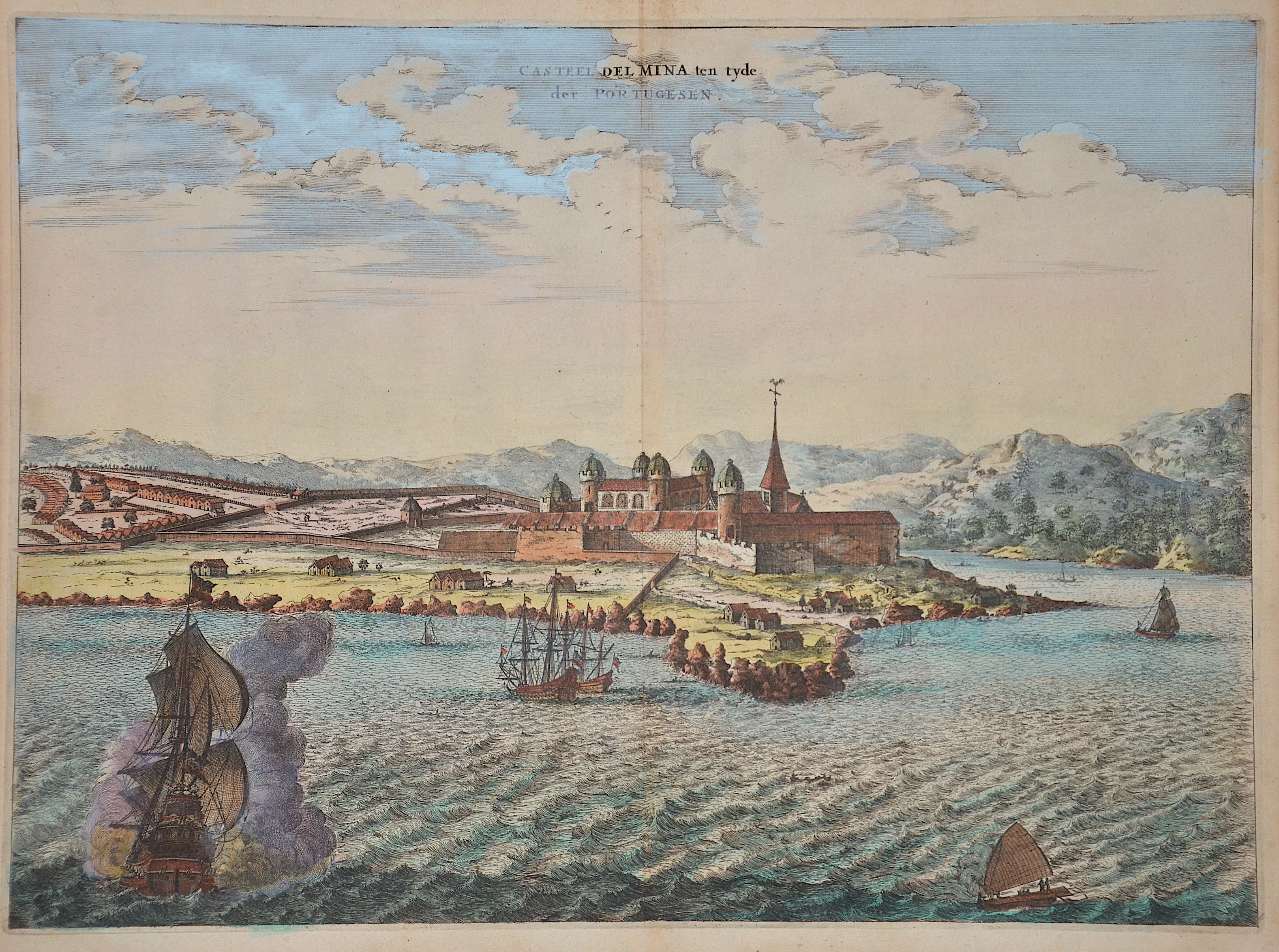
Casteel del Mina ten tyde der Portugesen.

| Article ID | AF0549 |
Title | Casteel del Mina ten tyde der Portugesen. |
Description | View of St. George's Castle or Elmina Castle in Ghana with sailing ships in front. |
| Year | ca. 1670 |
Artist | Ogilby (1600-1676) |
John Ogilby was a Scottish translator, impresario and cartographer. Best known for publishing the first British road atlas, he was also a successful translator, noted for publishing his work in handsome illustrated editions. John Ogilby's career as a publisher and printer was gradual. The first editions of his Virgil and Aesop transmissions were published by John and Andrew Crook, both of whom were known for the poor quality of their printed works. His edition of Virgil's works, printed in 1654, was already a splendid volume, of which Ogilby wrote jubilantly that it was "the most beautiful that English printing can boast of so far". Ogilby had financed the printing of the lavish Virgil edition with a method that was hardly known until then, the subscription. To illustrate the work, he had one hundred full-page copperplate engravings made based on designs by the renowned painter Francis Cleyn. Subscribers could then have each individual engraving marked with their name, rank and coat of arms on the lower edge of the picture for a fee and in this way demonstrate their love of art on display. In this way, Ogilby could not only pay for the high manufacturing costs, but also satisfy the vanity of his subscribers. The financing of publishing projects through subscription was still new and little tried at the time - alongside the London publisher Richard Blome, Ogilby was one of the pioneers of subscription in the English publishing business of the 17th century. John Ogilby's -Arnold Montanus (1625-1683) Montanus' De Nieuwe en Onbekende Weereld (The New and Unknown World) appeared in 1673, first published by the Dutch doctor and historian Olfert Dapper (Amsterdam) and later by John Ogilby (Amsterdam) has been. This work is also a treasure trove for materials on America. It contains, among other things, maps of Virginia, Carolina, New England, America (with California as an island), Bermuda, Brazil, Peru, Venezuela, Chile, Paraguay. The copper engravings include an early view of New York, as well as views of Mexico, Carolina, Terceira, Puerto Rico (Porto Rico), Santo Domingo, Havana, St. Augustine / Florida, St. Martin, Campeche, Acapulco, Cartagena Trujillo in Honduras, Callao de Lima, Bay de Todos os Sanctus in Bahia / Brazil, San Salvador, Tamaraca, Olinda de Phernambuco and Mauritsstaad (Mauritiopolis). | |
Historical Description | The first inhabitants of Ghana were members of the Sango or Sangoan culture - named after the first locations in Sango Bay on the Ugandan side of Lake Victoria. The population strata in Ghana and Togo, which are now considered to be autochthonous, are essentially groups who immigrated in large groups from the north or northeast to the areas south of the savannah belt of Togo and Ghana from the 9th and 10th centuries. This migratory movement was triggered by a change in the climate, which was associated with changes in the vegetation of the savannah areas. The modern state of Ghana takes its name from the ancient Kingdom of Ghana, which was geographically located a few thousand kilometers northwest and has no ethnic or historical connection to the current state of Ghana. In the pre-colonial period there were several large empires or federations on the territory of the present-day state. The first of these states, the empires of Dagomba, Mamprusi or Gonja, arose in the savannah region in northern Ghana and was culturally shaped by the empire of the Mossi further north and by Islam. Around 1600 the Ashanti Empire began to rise in central Ghana to become the dominant power in all of present-day Ghana. On the Gold Coast, the fortified settlements of European powers (Portuguese, English, Dutch, Brandenburgers, Swedes, Danes) have been lined up in a density like in no other area of Africa since the 17th century. Around 1820 the Colonial Office took over the British trading post on the Gold Coast. An agreement was reached between the British and the Fanti to defend themselves against the Ashanti from inland. In 1874 the British declared the coastal strip a crown colony. In 1957 the British crown colony Gold Coast and British Togoland became independent under the name Ghana. |
| Place of Publication | London |
| Condition | Perfect condition |
| Coloring | original colored |
| Technique | Copper print |