

Adina Sommer
Antique and Contemporary Art
Winzerer Str. 154
80797 München
telephone
+49 89 304714
business hours:
by appointment
Email
![]()


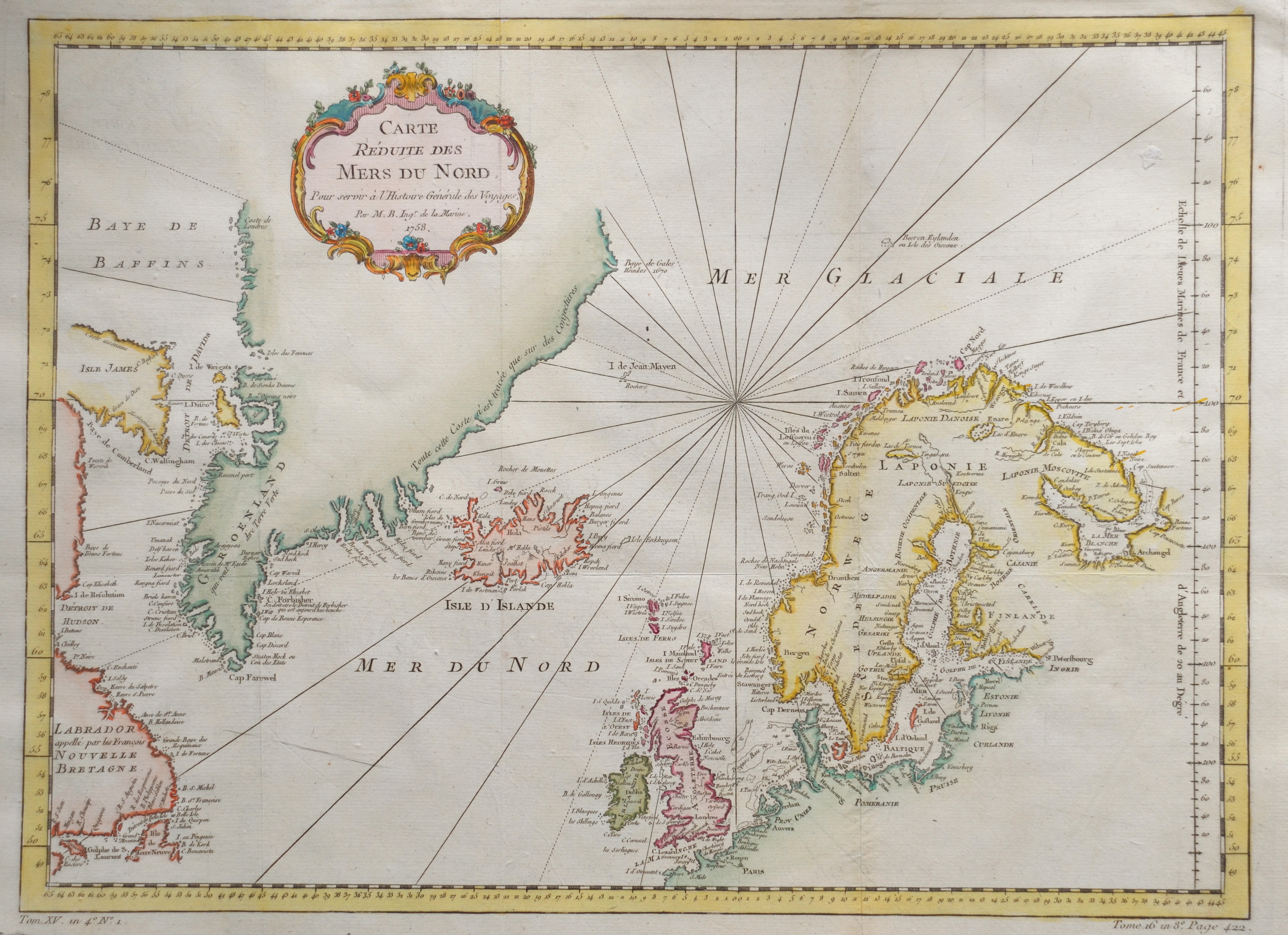
Carte reduite des mers du nord

| Article ID | EUS619 |
Title | Carte reduite des mers du nord |
Description | Map shows Skandinavie, Greenland, Iceland and Great Britain. |
| Year | dated 1758 |
Artist | Bellin (1703-1772) |
Jacques-Nicolas Bellin (1703 Paris -1772 Versailles) was a French cartographer, engineer-geographer, marine hydrographer. As a contributor to the Encyclopédie, he wrote more than a thousand articles on maritime topics. As a cartographer, Bellin distinguished himself primarily in the field of sea cartography. From 1721 he worked for the Dépot des Cartes et Plans de la Marine, from 1741 until his death as an engineer-hydrograph of the Navy. In 1753 his atlas Neptune français, which covered all the coasts of France, was published, and in 1756 the hydrography françoise covering all seas of the earth. In 1764 the five-volume Petit Atlas maritime was published, which Bellin prepared on the orders of the Minister of the Navy, Choiseul. In addition, he wrote a number of geographical works and with Nouvelle méthode pour apprendre la geographie (1769) a geographic textbook for teaching. His maps illustrated, among other things, Bougainville's work Voyage autour du monde, published in 1771. As a co-author of the Encyclopédie edited by Diderot and d'Alembert, Bellin wrote more than a thousand articles in the field of shipping and navy. | |
Historical Description | Scandinavia characterized by common ethnocultural North Germanic heritage and mutually intelligible North Germanic languages The term Scandinavia in local usage covers the three kingdoms of Denmark, Norway, and Sweden, but in English usage, it also sometimes refers to the Scandinavian Peninsula or to the broader region which includes Finland and Iceland This broader region is usually known locally as the Nordic countries. The remote Norwegian islands of Svalbard and Jan Mayen are usually not seen as a part of Scandinavia, nor is Greenland, a constituent country within the Kingdom of Denmark. The Faroe Islands may be included. For more than 500 years there was a common ground in the field of foreign policy, from the attack by the Danish king Chlochilaicus on Gaul (517) to the unfortunate move by Harald Hardrades against England in 1066, the Vikings carried out their raids and raids on all European coastal areas, but also deep into Russia stretch. For a long time, another commonality was the rejection of Christianity in times when it had been common in Western Europe for centuries. In addition, the great importance of the Jarle, who were initially only leaders of raids, but as such became very rich and powerful, is characteristic of this period. For this reason, fiefdom in Scandinavia developed much more slowly than in core Europe, and serfdom did not become fully established. In addition to these general similarities, there were also times when several of the Scandinavian countries were united under one rule, such as Denmark, Norway and (more relaxed) Sweden as well as England under Knut the Great from 1028 to 1035, as well as England. Denmark and Norway were soon under the common rule of Magnus the Good from 1042 to 1046. But the main time of the common political development lies in the Kalmar Union, which the countries of Denmark, Norway and Sweden were linked from 1397 to 1523. During this period, Norway lost significant political independence, so that after Sweden left the Kalmar Union with the Danish-Norwegian personal union, there was practically Danish dominance until 1814, which was replaced in 1814 by the Swedish-Norwegian union, which continued until 1905. |
| Place of Publication | Paris |
| Dimensions (cm) | 34 x 45 |
| Condition | Perfect condition |
| Coloring | colored |
| Technique | Copper print |