

Adina Sommer
Antique and Contemporary Art
Winzerer Str. 154
80797 München
telephone
+49 89 304714
business hours:
by appointment
Email
![]()


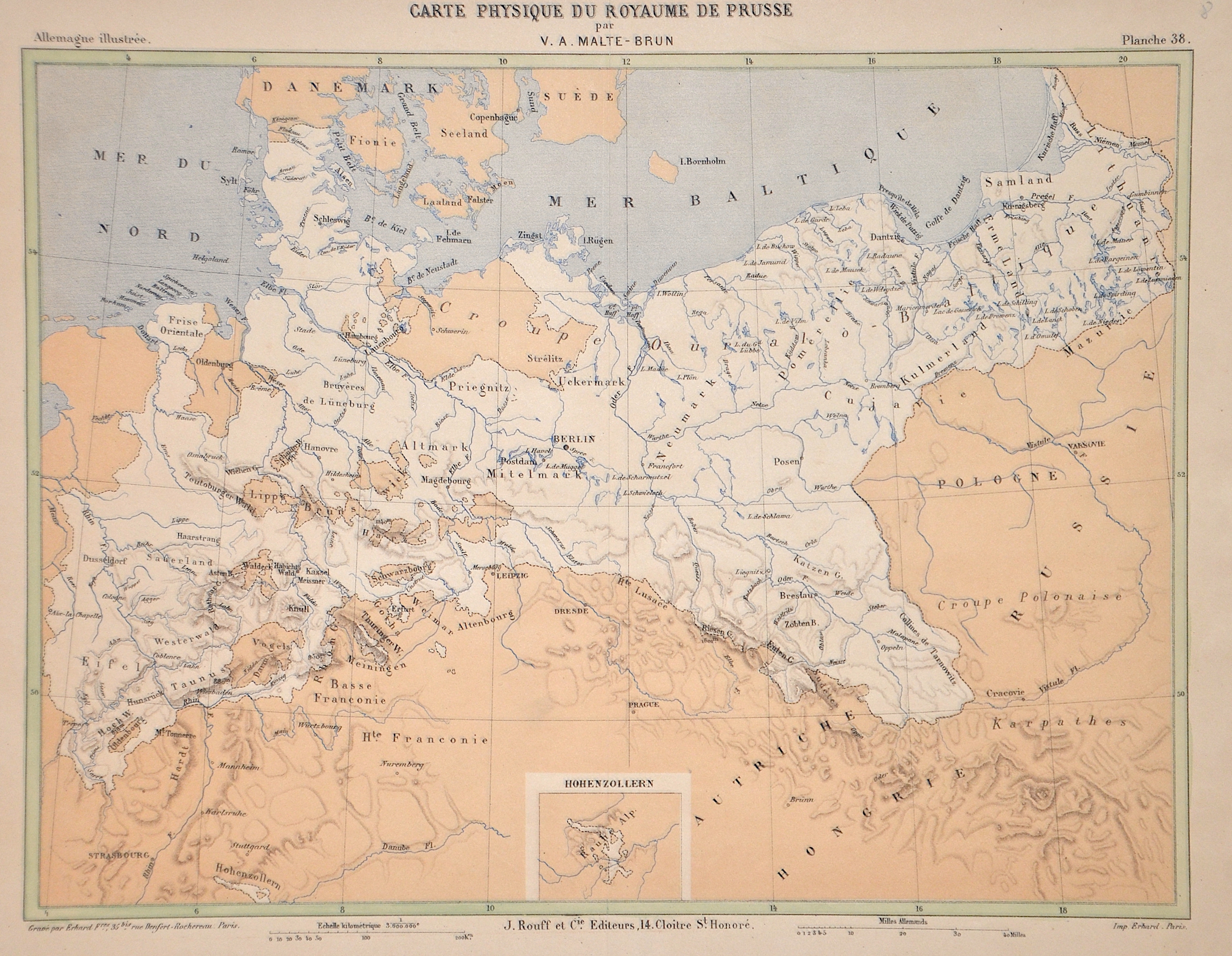
Carte Physique du Royaume de Prusse

| Article ID | EUP3197 |
Title | Carte Physique du Royaume de Prusse |
Description | Map in physical geography (light-coloured area = the Prussian state) shows today's Prussia, Silesia, Brandenburg, Schleswig Holstein, Hanover, Hesse, Nassau, Rhineland-Palatinate, Saxen-Anhalt and a partial map of Hohenzollern. |
| Year | ca. 1888 |
Artist | Malte-Brun (1816-1889) |
Victor Adolphe Malte-Brun was a french Georapher and Map maker.Victor Adolphe Malte-Bruns' father, Conrad Malte-Bruns, was the founder of the Société de Géographie. | |
Historical Description | Prussia: The name Prussia derives from the Old Prussians; in the 13th century, the Teutonic Knights—an organized Catholic medieval military order of German crusaders—conquered the lands inhabited by them. It was a historically prominent German state that originated in 1525 with a duchy centred on the region of Prussia on the southeast coast of the Baltic Sea. It was de facto dissolved by an emergency decree transferring powers of the Prussian government to German Chancellor Franz von Papen in 1932 and de jure by an Allied decree in 1947. For centuries, the House of Hohenzollern ruled Prussia, successfully expanding its size by way of an unusually well-organised and effective army. Prussia, with its capital in Königsberg and from 1701 in Berlin, decisively shaped the history of Germany. The Thirteen Years' War (1454–1466) began when the Prussian Confederation, a coalition of Hanseatic cities of western Prussia, rebelled against the Order and requested help from the Polish king, Casimir IV Jagiellon. The Teutonic Knights were forced to acknowledge the sovereignty of, and to pay tribute to Casimir IV in the Second Peace of Thorn (1466), losing western Prussia (Royal Prussia) to Poland in the process. Pursuant to the Second Peace of Thorn, two Prussian states were established. In 1701, Frederick William's son, Elector Frederick III, upgraded Prussia from a duchy to a kingdom and crowned himself King Frederick I. In the Crown Treaty of 16 November 1700, Leopold I, emperor of the Holy Roman Empire, allowed Frederick only to title himself "King in Prussia", not "King of Prussia". The state of Brandenburg-Prussia became commonly known as "Prussia", although most of its territory, in Brandenburg, Pomerania, and western Germany, lay outside Prussia proper. The Prussian state grew in splendour during the reign of Frederick I, who sponsored the arts at the expense of the treasury. During the reign of King Frederick William II (1786–1797), Prussia annexed additional Polish territory through further Partitions of Poland. His successor, Frederick William III (1797–1840), announced the union of the Prussian Lutheran and Reformed churches into one church. |
| Place of Publication | Paris |
| Dimensions (cm) | 26,5 x 33 cm |
| Condition | Perfect condition |
| Coloring | colored |
| Technique | Colored Lithography |