

Adina Sommer
Antique and Contemporary Art
Winzerer Str. 154
80797 München
telephone
+49 89 304714
business hours:
by appointment
Email
![]()


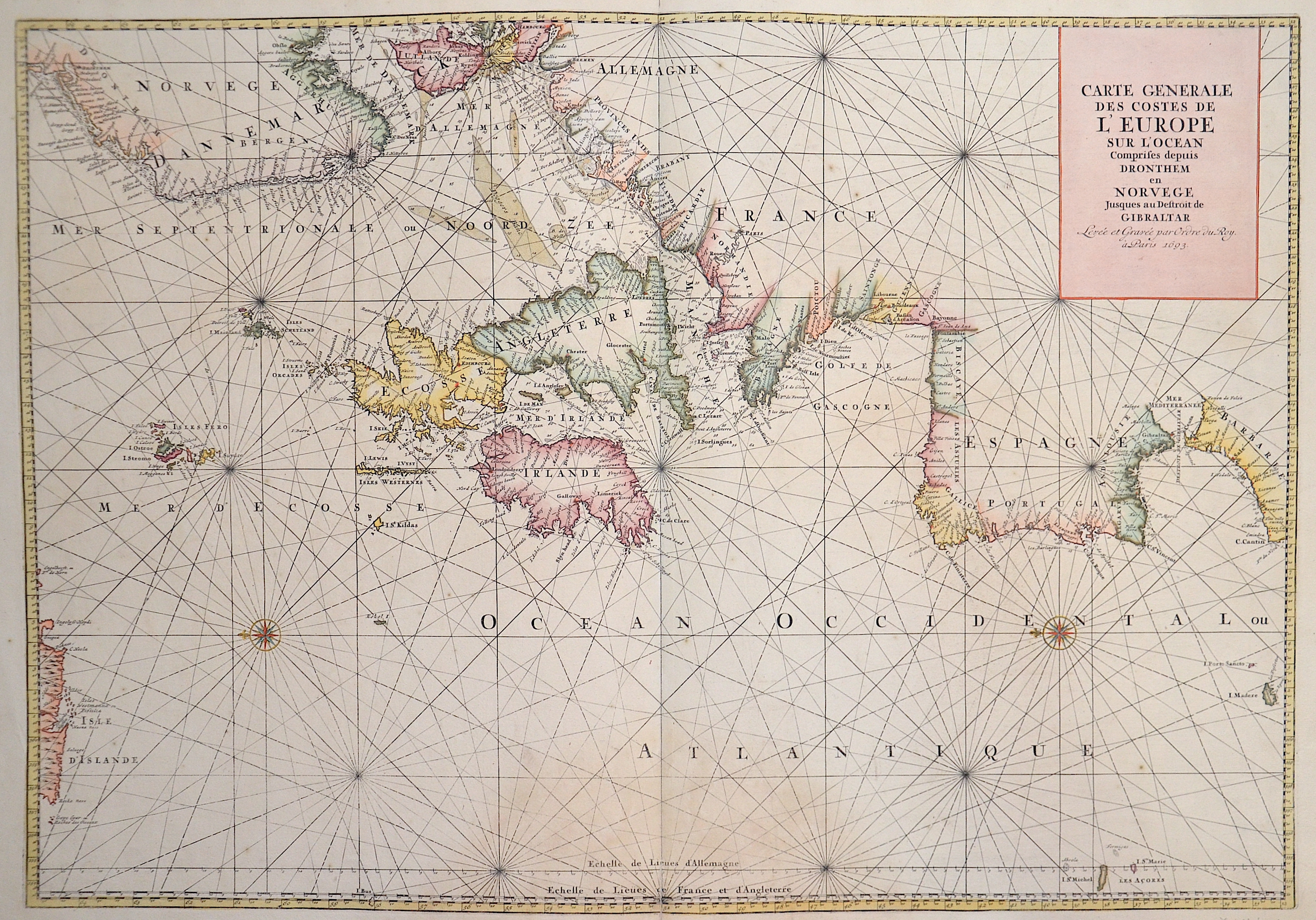
Carte Generale des Costes de l’Europe sur l’Ocean Comprises depuis Dronthem en Norvege Jusques au Destroit de Gibraltar.

| Article ID | SE0302 |
Title | Carte Generale des Costes de l’Europe sur l’Ocean Comprises depuis Dronthem en Norvege Jusques au Destroit de Gibraltar. |
Description | Sea chart of coasts of Great Britain, the the Faroer islands, Shettlands, Azores and the western coast of Europe with Portugal, Spain, France, Netherlands, Germany, Denmark and Norway. |
| Year | ca. 1693 |
Artist | Jaillot (1632-1712) |
Alexis Hubert Jaillot (1632-1712) was an important French cartographer and publisher. In 1665 Jaillot married into the Berey family of map publishers. After the death of his brother-in-law Nicolas II Berey (1640–1667) he bought the Berey card collection from his sister-in-law. This gave him a valuable foundation that he could market straight away without ever having made a map himself. Jaillot entered the card business at an opportune moment. In early 1668, Louis XIV won the first of his Reunion Wars, and a period began when France was constantly expanding its territory. There was a great demand for maps depicting the French triumphs and the new frontiers, as well as upcoming expansion plans. Jaillot's map collection also included printing plates that Pierre Duval (1619–1683) (nephew of Nicolas Sanson) had created and originally sold to Nicolas Berey. But Duval, who also mislaid his cards himself, resisted the re-edition of his old cards. At the height of the dispute with Duval, Jaillot won Nicolas Sanson's sons Guillaume and Adrien in late 1670 as card makers and business partners. With them he was able to market new cards with the prestigious name Sansons. His first atlas of 1681, Atlas Nouveau, became such a great commercial success that other publishers began selling plagiarism. | |
Historical Description | For a long time in human history, the Atlantic was the great body of water that separated the "Old World" from the "New World." Covering an area of about 106 million square kilometers, the Atlantic Ocean makes up roughly one-fifth of the Earth's surface. Due to its vast size, the Atlantic is commonly divided into the North Atlantic and the South Atlantic. In the 17th century, the Atlantic Ocean was a central stage for global trade, colonialism, and naval power politics among the European powers. European countries such as Spain, Portugal, England, France, and the Netherlands used the Atlantic for their colonial ventures. The Americas, West Africa, and the Caribbean were interconnected through the Atlantic—economically, politically, and militarily. The transatlantic triangular trade flourished: European goods were brought to Africa, exchanged for enslaved people, who were then shipped to the Americas. From there, raw materials such as sugar, tobacco, or cotton were transported back to Europe. Thus, the Atlantic was also a major zone of intensive slave trade. The Atlantic routes were dangerous: in addition to natural hazards, there were also pirates and conflicts between rival colonial powers. By around 1680, the Atlantic had become the backbone of the emerging global economic system—shaped by colonialism, the slave trade, and naval power. It connected continents, but also spread violence, exploitation, and power struggles. After Christopher Columbus's first crossing in 1492, regular ocean crossings did not begin until the 19th century. People in Europe wanted to leave behind the poor living conditions of the time and start a new life in the rapidly developing Americas. This led to large waves of emigration.The first transatlantic steamship set sail from Bremerhaven on July 2, 1847. |
| Place of Publication | Paris |
| Dimensions (cm) | 59 x 85 |
| Condition | Some restoration at lower centerfold |
| Coloring | original colored |
| Technique | Copper print |