

Adina Sommer
Antique and Contemporary Art
Winzerer Str. 154
80797 München
telephone
+49 89 304714
business hours:
by appointment
Email
![]()


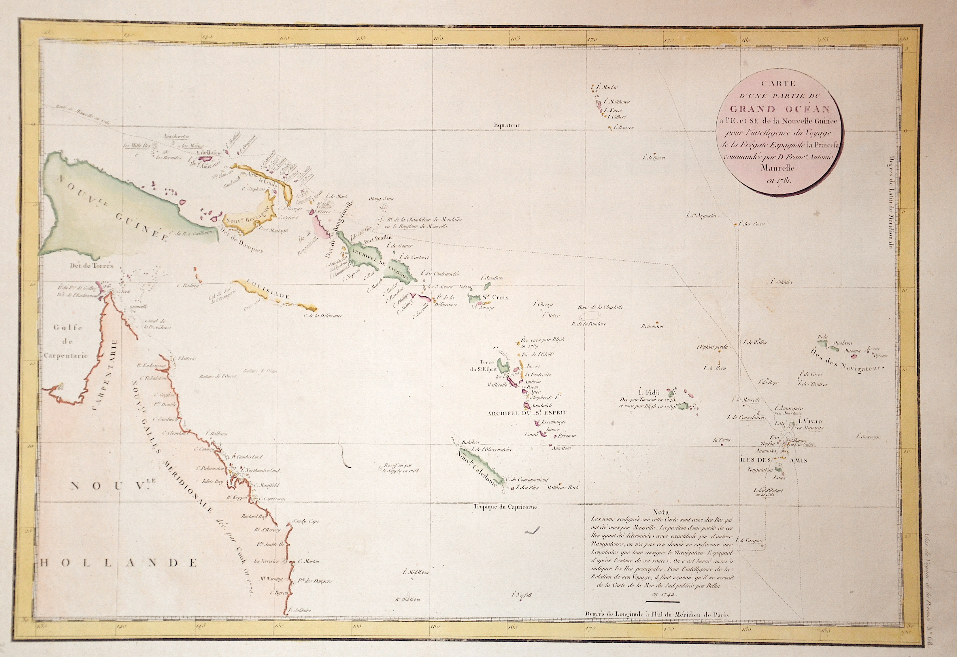
Carte d´une partie du Grand Ocean….

| Article ID | OZ0306 |
Title | Carte d´une partie du Grand Ocean…. |
Description | Map shows the east coast of Australia, with the Melanesian islands of New Guinea, Solomon Islands, New Caledonia and the Fiji Islands, as well as the Polynesian islands of Tonga and the Cook Islands. |
| Year | dated 1781 |
Artist | Cook/ Whitchurch (1728-1779) |
The first voyage of James Cook was a combined Royal Navy and Royal Society expedition to the south Pacific Ocean aboard HMS Endeavour, from 1768 to 1771. It was the first of three Pacific voyages of which Cook was the commander. The aims of this first expedition were to observe the 1769 transit of Venus across the Sun and to seek evidence of the postulated Terra Australis Incognita or "unknown southern land". | |
Historical Description | Oceania is the name for the island world of the Pacific north and east of the continent of Australia. In English, the term transoceania is also used. This term originated mainly for economic reasons in Australia and New Zealand and describes an area from northern Australia via Indonesia to the southern border of the Philippines and the far west of the Pacific islands. The term "South Sea" was coined in 1513 by Vasco Núñez de Balboa, when he had crossed the isthmus of Panama and called the sea (Pacific) in front of him Mar del sur (South Sea), as he was facing south from his location looked. Central island groups are the Society Islands (French Polynesia / Tahiti), the Samoa Archipelago and the Fiji Islands. In November 1520 Ferdinand Magellan, coming from the Strait of Magellan, reached the Pacific or the Pacific Ocean while circumnavigating the world. He called it Mar Pacifico (Portuguese and Spanish for Peaceful Seas) because the storms that had accompanied it until then subsided. Despite this name, there are also violent storms and cyclones in the Pacific, which are called typhoon or hurricane depending on the region. The spirit of discovery of the 16th century is decisive for numerous expeditions. The first focus is on exploring a western route across the Pacific to the rich trading centers of Asia. Later, mainly Spanish and Portuguese adventurers search for the hypothetical southern continent Terra Australis Incognita or hope to find legendary riches such as the mines of King Solomon. Due to inadequate navigation techniques, some of the island groups discovered, e.g. B. the Solomon Islands, cannot be found again and fell into oblivion. At the end of the 16th century, the Dutch began exploring Oceania too. In the 17th century there is still a lot undiscovered in the Pacific and, above all, the stories of those returning home from Paradise attract more and more sailors. The motivation to travel to new worlds is great, but goes hand in hand with the greed for the pristine natural resources of the new world. The church is meanwhile worried about the "mixing" with the heathen peoples, but is nevertheless interested in the salvation of the "savages". She reacts by publicly discrediting the fornication with the inhabitants and delegating missionaries to assist with the trips. In the 18th century there were less and less available on undiscovered islands, but circumnavigators like Louis Antoine de Bougainville, James Cook and others still found some unexplored areas. In addition, some of the discoveries made in the 16th century were forgotten again. Some now set about mapping the islands using modern means. In the 18th century, mapping continued and imperialism is beginning to take effect. Foreign island groups are increasingly being divided up among the great powers. The colonization of the South Pacific is becoming a race. Above all, Germans, British, French, Dutch and Americans fight over every island. At the end of the 19th century, the Spanish-American War led to a wild castling of the colonial territories. |
| Dimensions (cm) | 34 x 49,5 |
| Condition | Very good |
| Coloring | original colored |
| Technique | Copper print |