

Adina Sommer
Antique and Contemporary Art
Winzerer Str. 154
80797 München
telephone
+49 89 304714
business hours:
by appointment
Email
![]()


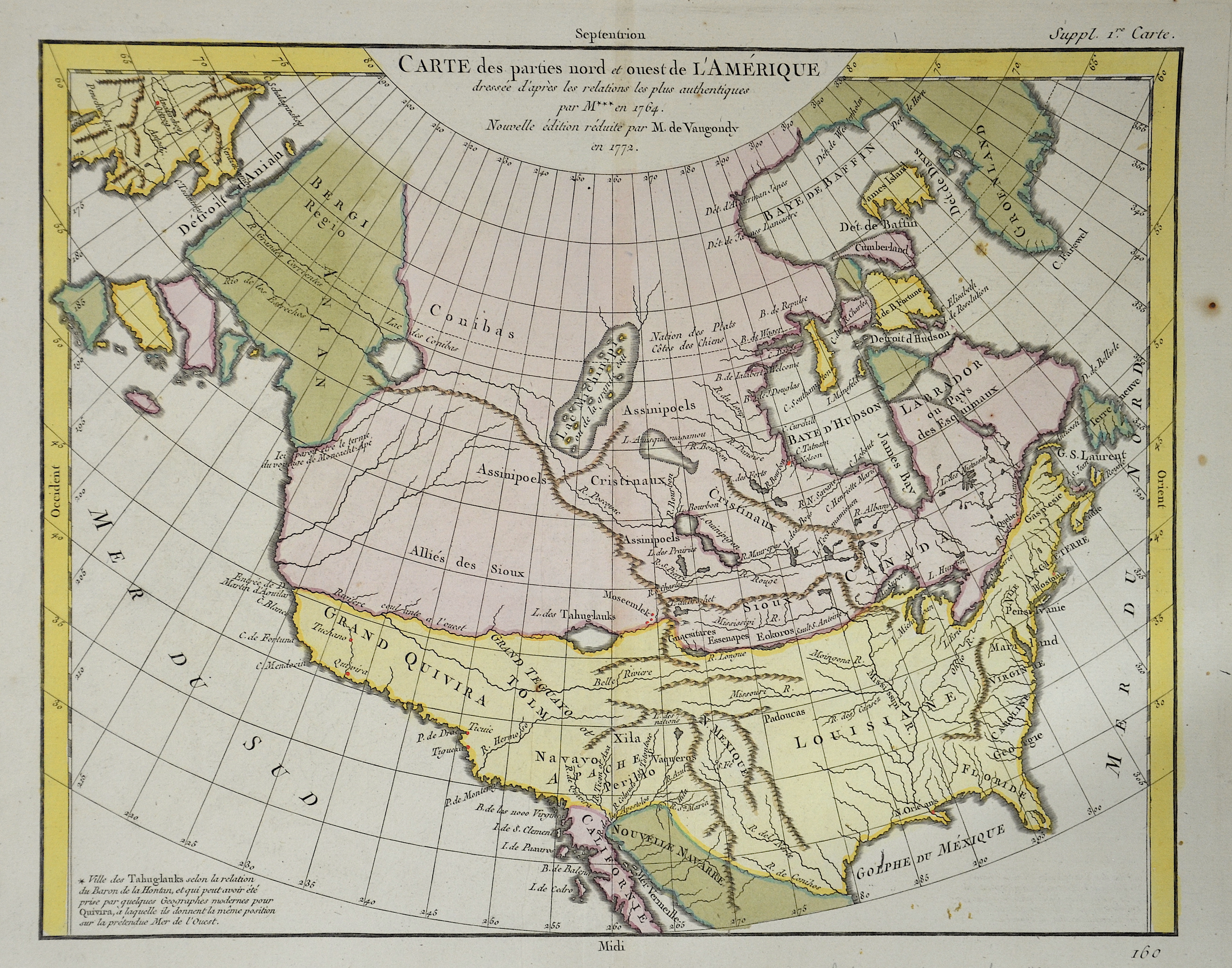
Carte des Parties nord et quest de l´ Amerique

| Article ID | AMC0778 |
Title | Carte des Parties nord et quest de l´ Amerique |
Description | Map shows total Canada with USA. |
| Year | dated 1772 |
Artist | Vaugondy,de (1723-1786) |
Didier Robert de Vaugondy (1723 -1786) also known as Le Sieur or Monsieur Robert, and his son, were leading cartographers in France during the 18th century. In 1757, Gilles and Didier Robert De Vaugondy published The Atlas Universel, one of the most important atlases of the 18th century. To produce the atlas, the Vaugondys integrated older sources with more modern surveyed maps. They verified and corrected the latitude and longitude of many regional maps in the atlas with astronomical observations. The older material was revised with the addition of many new place names. In 1760, Didier Robert de Vaugondy was appointed geographer to Louis XV. Gilles and Didier Robert De Vaugondy produced their maps and terrestrial globes working together as father and son. Globes of a variety of sizes were made by gluing copperplate-printed gores on a plaster-finished papier-mache core, a complicated and expensive manufacturing process, employing several specialists. In some cases it is uncertain whether Gilles or Didier made a given map. Gilles often signed maps as M.Robert, while Didier commonly signed his maps as ""Robert de Vaugondy"", or added ""fils"" or ""filio"" after his name. The Robert de Vaugondys were descended from the Nicolas Sanson family through Sanson's grandson, Pierre Moulard-Sanson. From him, they inherited much of Sanson's cartographic material, which they combined with maps and plates acquired after Hubert Jaillot's death in 1712 to form the basis the Atlas Universel. | |
Historical Description | Various indigenous peoples have inhabited what is now Canada for thousands of years before European colonization. Beginning in the 16th century, British and French expeditions explored and later settled along the Atlantic coast. As a consequence of various armed conflicts, France ceded nearly all of its colonies in North America in 1763. In 1867, with the union of three British North American colonies through Confederation, Canada was formed as a federal dominion of four provinces. In 1583, Sir Humphrey Gilbert, by the royal prerogative of Queen Elizabeth I, founded St. John's, Newfoundland, as the first North American English colony. French explorer Samuel de Champlain arrived in 1603 and established the first permanent European settlements at Port Royal (in 1605) and Quebec City (in 1608). Among the colonists of New France, Canadiensextensively settled the Saint Lawrence River valley and Acadians settled the present-day Maritimes, while fur traders and Catholic missionaries explored the Great Lakes, Hudson Bay, and the Mississippi watershed to Louisiana. The Beaver Wars broke out in the mid-17th century over control of the North American fur trade. The Royal Proclamation of 1763 established First Nation treaty rights, created the Province of Quebec out of New France, and annexed Cape Breton Island to Nova Scotia. After the successful American War of Independence, The 1783 Treaty of Paris recognized the independence of the newly formed United States and set the terms of peace, ceding British North American territories south of the Great Lakes to the new country. the Constitutional Act of 1791 divided the province of Canada into French-speaking Lower Canada (later Quebec) and English-speaking Upper Canada (later Ontario), granting each its own elected legislative assembly. |
| Place of Publication | Paris |
| Dimensions (cm) | 29,5 x 36 |
| Condition | Very good |
| Coloring | colored |
| Technique | Copper print |