

Adina Sommer
Antique and Contemporary Art
Winzerer Str. 154
80797 München
telephone
+49 89 304714
business hours:
by appointment
Email
![]()


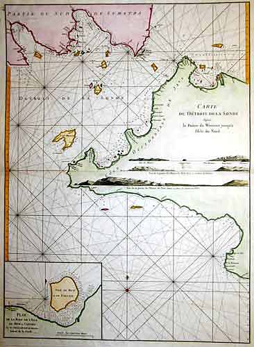
Carte des Détroit de la Sonde…

| Article ID | ASS130 |
Title | Carte des Détroit de la Sonde… |
Description | chart of the Sunda Strait |
| Year | ca. 1775 |
Artist | Mannevillette (1707-1775) |
Jean Babtiste D´Apres de Mannevillette ( 1707-1780) was a sailor, Mathematician and hydrographer. His father captain in the " Camaigne des Indes" or French East India Company. Recognizing the poor quality of charts published for the route to the Far East thus far, Manvillette set out to upgrade them. During the mid 1730´s he collected data and updated charts which culminated in 1745 with the issurance of " Le Neptune Oriental" which comprised of 22 charts. This work was quickly recognized as beeing a great advancement over all earlier works. During the remainder of his life Manevillette continued to update and add new information and in 1775 isued an enlarged edition containing 63 charts. This new edition contained many chrats that were based on information collected by Alexander Darymple, a Scottish geographer and later the first hydrographer of the British Admiralty. | |
Historical Description | The Sunda Strait is a strait between the Indonesian islands of Sumatra and Java. The Sunda Islands are part of the Malay Archipelago.Several islands are located in the strait, including Krakatau Island, which is famous for the volcanic eruption of 1883. Besides the Strait of Malacca, it is the most important connection from the South China Sea to the Indian Ocean. All large and most of the smaller Sunda islands are each surrounded by a ring of even smaller to smallest islands. Sumatra, Java and the Lesser Sunda Islands together form the Sunda Arc. Most of the Sunda Islands belong politically to Indonesia. The north of Borneo belongs for the most part to Malaysia, a small part forms the state of Brunei. The following seas, up to 600 km wide, lie between the islands in a ring around Borneo and Sulawesi: northwest of Borneo the South China Sea, south the Java Sea, east the Celebes Sea. East of Sulawesi are the Molucca Sea and the Banda Sea. Other seas in the region are the Flores Sea, the Sawu Sea and, to the south, the Timor Sea. |
| Place of Publication | Paris |
| Dimensions (cm) | 69,5 x 51 |
| Condition | Very good |
| Coloring | colored |
| Technique | Copper print |
Reproduction:
73.50 €
( A reproduction can be ordered individually on request. )