

Adina Sommer
Antique and Contemporary Art
Winzerer Str. 154
80797 München
telephone
+49 89 304714
business hours:
by appointment
Email
![]()


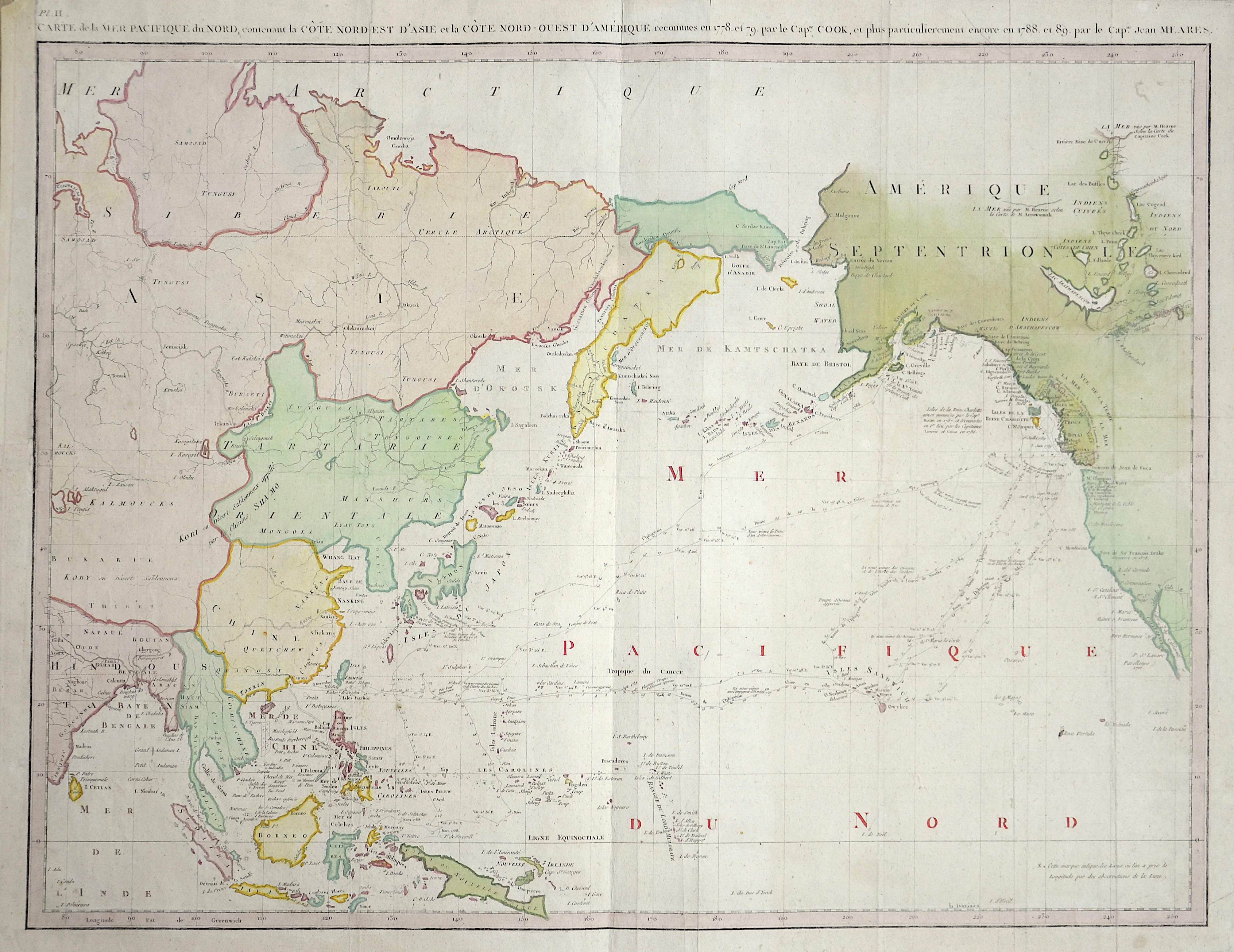
Carte de la Mer Pacifique du Nord, contenant la Cote Nord-Est d’Asie et la Cóte Nord-Ouest d’Amérique.

| Article ID | ASI1261 |
Title | Carte de la Mer Pacifique du Nord, contenant la Cote Nord-Est d’Asie et la Cóte Nord-Ouest d’Amérique. |
Description | The map shows the regions from Central Asia to Baja California, but the primary focus is on the tracks of the various explorers through the Northwest, Alaska, Canada, Hawaii and on to Western Pacific and Southeast Asia. Meares' maps are far scarcer than Cook's maps. Includes extensive annotations throughout the map, including datelines on the tracks of Meares and Cook. |
| Year | ca. 1790 |
Artist | Meares |
Historical Description | In the first centuries after the turn of the times, Indian traders spread their culture over large parts of Southeast Asia. The Kingdom of Funan (200-550) in the Mekong Delta developed into the first center of Hinduism and Buddhism in Southeast Asia. It was replaced by the Khmer Kingdom and the Srivijaya Empire in Sumatra. 750 Borobodur was built on Java, a terraced temple complex of enormous size. The Khmer kings created an equally impressive work of art with the construction of their Angkor Wat temple complex. From the 9th century, the Tai migrated from the north to their present-day settlement areas and met the high-ranking Mon, whose culture they shaped. In 1044 the first Burmese Empire was founded with Bagan as the capital. In Southeast Asia, extensive trade had developed from the 6th to the 16th century, numerous shipwrecks testify to this development, such as that of the Lena Shoal junk. The ship types of the junk and the balangay were used for this trade. Two main routes of trade China on the one hand and Java, Sumatra and the Malay Peninsula on the other hand could be determined. One route leads along the mainland and the second route along Borneo, Palawan to the island of Luzon. In the 15th century, Arab, Persian and Indian traders converted the Malays to Islam. The Muslim Malacca took the place of the Hindu kingdom Majapahit on Java. With the exception of Siam, all Southeast Asian countries were colonized from the 16th century. The background to colonization was the region's wealth of raw materials and spices, which were of particular value at the time. After the trade had been dominated by Arab traders for a long time, the European powers now fought over supremacy in the region. The Spaniards became active in the region at the same time and colonized with the aim of conquering China and converting to Christianity the Philippines, which they named after the Spanish King Philip II. The British came to Southeast Asia as the third major colonial power and also tried to establish themselves in the region. After initially holding an insignificant base in Indonesia, after negotiating with the local sultans, they reached control of the island of Penang and Singapore, which was then a small Malay fishing village. Together with the port city of Malacca, these areas formed the so-called Straits Settlements, the most important bases for the British in Southeast Asia. |
| Place of Publication | Paris |
| Dimensions (cm) | 43,5 x 56,5 cm |
| Condition | Upper Left margin perfectly replaced |
| Coloring | colored |
| Technique | Copper print |