

- Alsace
- Aquitaine
- Auvergne
- Bourgogne
- Bourgogne-Franche-Comte
- Brittany
- Centre
- Champagne
- France Islands
- Gascogne
- Gironde
- Hauts-de-France
- Ile de France
- Languedoc
- Lothringen
- Midi-Pyrénées
- Nivernais
- Nord-Pas-de-Calais
- Normandie
- Occitanie
- Pas-de-Calais
- Pays de la Loire
- Picardie
- Poitou-Charentes
- Provence-Alpes-Cote d Azur
- Pyrénées
- Rhone- Alpes
- Saintonge
- Savoyen
- Tourain
- Westcoast
Adina Sommer
Antique and Contemporary Art
Winzerer Str. 154
80797 München
telephone
+49 89 304714
business hours:
by appointment
Email
![]()


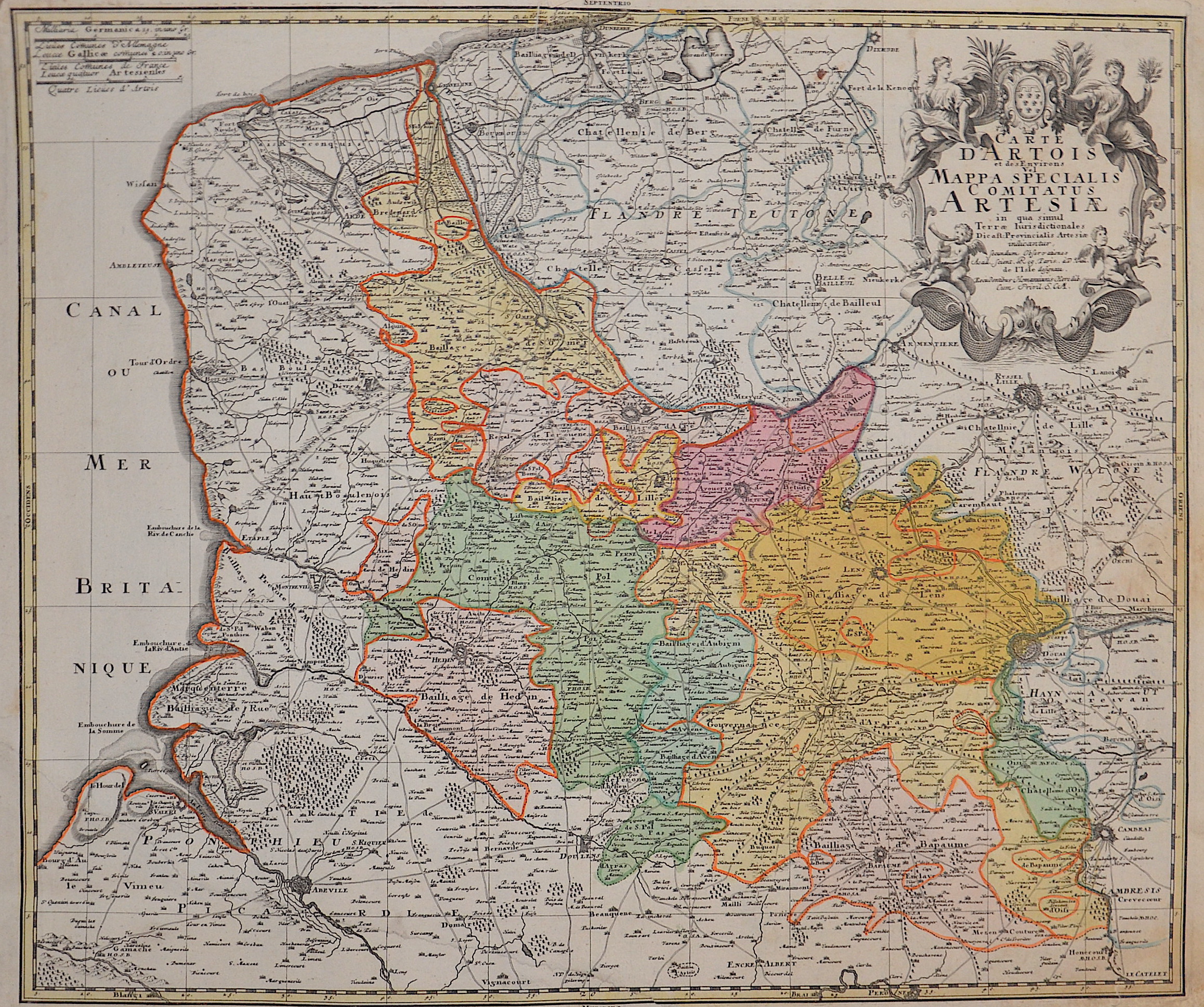
Carte d’Artois et des Environs Vel Mappa Specialis Comitatus Artesiae..

| Article ID | EUF4655 |
Title | Carte d’Artois et des Environs Vel Mappa Specialis Comitatus Artesiae.. |
Description | Map shows the historical province of Artois, it is located in the north of France in the interior of the today's department of Pas-de-Calais. Top right a title cartouche with the arms of the county of Artois. |
| Year | ca. 1730 |
Artist | Homann Erben (1724-1780) |
Johann Babtiste Homann (1664-1724) was born in Oberkammlach, the Electorate of Bavaria. Although educated at a Jesuit school, and preparing for an ecclesiastical career, he eventually converted to Protestantism and from 1687 worked as a civil law notary in Nuremberg. He soon turned to engraving and cartography; in 1702 he founded his own publishing house. Homann acquired renown as a leading German cartographer, and in 1715 was appointed Imperial Geographer by Emperor Charles VI. Giving such privileges to individuals was an added right that the Holy Roman Emperor enjoyed. In the same year he was also named a member of the Prussian Academy of Sciences in Berlin. Of particular significance to cartography were the imperial printing privileges (Latin: privilegia impressoria). These protected for a time the authors in all scientific fields such as printers, copper engravers, map makers and publishers. They were also very important as a recommendation for potential customers. In 1716 Homann published his masterpiece Grosser Atlas ueber die ganze Welt (Grand Atlas of all the World). Numerous maps were drawn up in cooperation with the engraver Christoph Weigel the Elder, who also published Siebmachers Wappenbuch. Homann died in Nuremberg. He was succeeded by the Homann heirs company, which was in business until 1848. The company was known as Homann Erben, Homanniani Heredes, or Heritiers de Homann abroad. | |
Historical Description | Pas-de-Calais is one of the 83 departments created in 1790 during the French Revolution in application of the law of December 1789. It was created by merging Artois and parts of Picardy, the Boulonnais and part of the Ponthieu. |
| Place of Publication | Nuremberg |
| Dimensions (cm) | 49 x 57,5 cm |
| Condition | Tear on lower part perfectly restored |
| Coloring | original colored |
| Technique | Copper print |